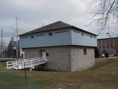
Merrickville Blockhouse National Historic Site of Canada
Merrickville, Ontario

showing former defensive ditch around the building
(© Parks Canada Agency / Agence Parcs Canada, 2004.)
Address :
279 Saint Lawrence Street, Merrickville, Ontario
Recognition Statute:
Historic Sites and Monuments Act (R.S.C., 1985, c. H-4)
Designation Date:
1939-05-29
Dates:
-
1832 to 1833
(Construction)
Event, Person, Organization:
Other Name(s):
-
Merrickville Blockhouse
(Designation Name)
DFRP Number:
09412 13
Plaque(s)
Existing plaque: mounted on north wall of buildling next to entrance 279 Saint Lawrence Street, Merrickville, Ontario
When construction of the Rideau Canal began, Merrickville was already an established village and was considered by the authorities to be a logical target for an invader. Consequently Colonel John By urged strong measures for the protection of the lock station. The result was this blockhouse, built in 1832-33, the largest on the Rideau Canal and the second largest surviving in Canada. It still resembles its early description as "a good blockhouse, the basement and ground floor being of stone, and the upper storey of wood covered with tin, the whole surrounded by a ditch".
Description of Historic Place
Merrickville Blockhouse is a two-storey, masonry and timber defensive structure located on the banks of the Rideau Canal in the town of Merrickville Ontario.
Heritage Value
Merrickville Blockhouse was designated a National Historic Site because it was considered a fine example of the best type of blockhouses erected for the defence of the Rideau Canal about 1832.
Its heritage value lies in its illustration of relatively large, 19th-century British designed blockhouse. Built in 1832-33, it is associated with the construction of the Rideau Canal waterway and the defence of Canada.
Source: HSMBC Minutes, May 1939, 1967; Commemorative Integrity Statement.
Character-Defining Elements
- the blocky massing, its large size relative to other defensible structures along the canal, the tripartite design with a squat lower storey, overhanging upper storey, and steep hipped roof, the symmetrical design with central door and regular window openings, the functional design as a defensive structure with sparse door and window openings and plentiful gun slits, the fire resistant design with thick, vented stone walls on the basement and first storey, remaining original fabric in the lower storey, evidence of designed self-sufficiency, particularly related to the sub-division of space into provision storage, armament storage and barrack areas, vestiges of former defensive ditch around the building, the spacial relationship to the Merrickville Lockstation, particularly in the land-use allocation and circulation patterns, siting at the Merrickville Lockstation, with an unobstructed view up and down the Rideau waterway and down the Prescott and Brockville Roads.