Building of the Canso Causeway National Historic Event
Port Hastings, Nova Scotia
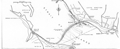
Sketch map
© Roads and Engineering Construction, Vol. 90, May 1952, p. 81
Address :
4 Fleur de Lis Trail, Port Hastings, Nova Scotia
Recognition Statute:
Historic Sites and Monuments Act (R.S.C., 1985, c. H-4)
Designation Date:
2005-08-03
Other Name(s):
-
Building of the Canso Causeway
(Designation Name)
Research Report Number:
2004-036 36A
Importance:
United Cape Breton physically, economically, and symbolically to the rest of Canada
Plaque(s)
Existing plaque: 4 Fleur de Lis Trail, Port Hastings, Nova Scotia
The foundation of this massive stone structure rests 66 metres below the Strait of Canso, creating the world's deepest causeway. More than 9 million tonnes of rock fill were dumped into the strait between 1952 and 1955 using innovative construction techniques to overcome strong tidal currents and severe ice conditions. This project proved the feasibility of deep-water construction on an unprecedented scale. The `Road to the Isle' now linked Cape Breton physically, economically, and symbolically with the rest of Canada.