Cook, Captain James National Historic Person
Corner Brook (NL) and Halifax (NS), N/A
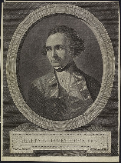
Captain James Cook
(© Library and Archives Canada | Bibliothèque et Archives Canada, Acc. No. 1970-84-20)
Address :
Corner Brook (NL) and Halifax (NS), N/A
Recognition Statute:
Historic Sites and Monuments Act (R.S.C., 1985, c. H-4)
Designation Date:
1945-05-16
Life Date:
1728 to 1779
Other Name(s):
-
Cook, Captain James
(Designation Name)
Research Report Number:
1960-011, 2010-SDC-CED-024
Importance:
Surveyed coast of Newfoundland (1763-67), Gulf of St. Lawrence and Nova Scotia (1758-62)
Plaque(s)
Plaque Removed: Halifax, Nova Scotia
James Cook distinguished himself for his “indefatigable industry” and his scientific skill during naval operations in the Gulf of St. Lawrence and around Nova Scotia between 1758 and l762. He spent those sane winters in Halifax compiling charts of the St. Lawrence and descriptions of the coast of Nova Scotia from previous charts and from the results of his summer surveys. Meanwhile, by adapting the techniques of military engineers to the marine situation, he evolved those new methods of surveying which he later put to such good use in Newfoundland and the South Pacific.
Existing plaque: Captain James Cook Historic Site, Crow Hill Road, Corner Brook, Newfoundland and Labrador
From 1763 to 1767 Captain James Cook, R.N., directed a survey embracing the greater part of the coast of Newfoundland. The charting of this coastline was the first scientific, large scale, hydrographic survey to use precise triangulation to establish land outlines. It produced a collection of charts which remained standard for a century. The choice of Cook to carry out Pacific exploration was the result of his success in Newfoundland. Cook's visit to this area on his ascent of the Humber as far as Deer Lake was part of the first serious attempt to delineate the inland topography of Newfoundland.