
Auriol Trail
Kluane National Park and Reserve
Distance: 15 km (9 mi) return trip
Time: 4-6 hrs or overnight
Elevation gain: 400 m (1,300')
Maximum elevation: 1,159 M (3,800')
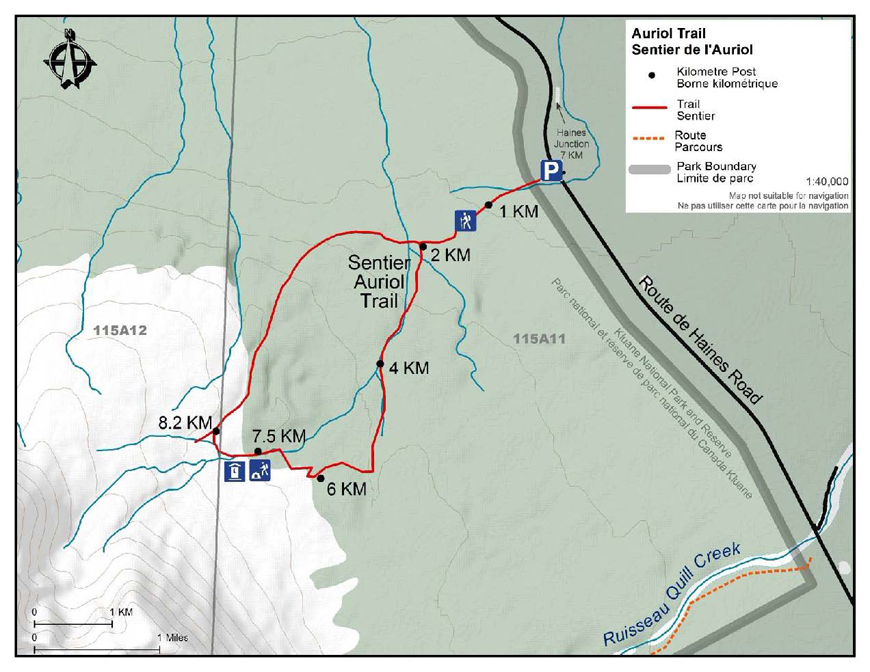
Trailhead: 7 km south of Haines Junction on the Haines Highway
Topo map: Auriol 115 A/12
In summary
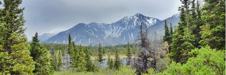
The Auriol trail is a half to a full day loop, which can be extended into an overnight trip. The trail is cut through mixed boreal forest and leads to a sub-alpine bench just in front of the Auriol Range. From the upper reaches of the trail there is the possibility of continuing up through the sub-alpine to areas of alpine and the mountain slopes. This trail is a common access route for people climbing Quill Peak, Mt. Martha Black and many of the unnamed peaks in the Auriol Range.
Download the Auriol Trail description (PDF, 531 Kb)
The details
From the trailhead the footpath crosses an open meadow and enters the trees near the far side. The trail climbs up gradually for the first two kilometers. At the 2 km point the trail branches into the loop. The left side of the loop is a more gradual climb to the highest point on the trail while the right side is steeper with more viewpoints. The trail to the left crosses a creek twice at about the 3 km and 3.5 km points on the trail. It then follows the creek up through a small valley until the forest opens up to meadows. The meadows, mixed with willow and a few wetland areas, are ideal places to spot a moose. The trail follows the meadows for some distance and, in wet years, there may be some wet areas along this section of the trail.
Once the trail passes a small pond, it then drops down into a long meadow and then turns sharply to the right up the hill into the trees. After a short section through the spruce forest the trail emerges into another small creek drainage valley. It then climbs out of the valley into the sub-alpine. From this point there are excellent views of the mountains of the Auriol Range rising out of the alpine. The trail meanders through the sub-alpine again following a creek drainage (during some years the creek may travel underground and there may not be water flowing in the channel especially later in the summer). The source of the creek is melt water flowing from and along the rock glacier, which is visible at the base of the mountains (the core of a rock glacier is ice). The trail follows and crosses the creek a few times.
A primitive campsite is located through the trees, to the right, at the 7.3 km mark. Here you will find an outhouse, a fire pit and 4 tent pads. The trail continues to ascend for another kilometer to the 8.2 km post, where it gradually begins to descend in an eastward direction. At this particular signpost a trail spurs up to a viewpoint 300 m away and then goes further into the Auriol range for those who want to explore off trail.
Once back on the trail, you will travel mostly through spruce forest. There are several good viewpoints along the way. As well, signposts indicate two established viewpoints off the trail. From here you will see the town of Haines Junction as well as the valley and Ruby Range Mountains in the distance. The U shaped and hanging valleys are two of the landforms seen from here, created long ago by glaciers. After crossing yet another footbridge (5th crossing of the same creek), the 12.8 km sign post will be reached, only 2 km before the parking area.
What you need to know
For all overnight trips in the park Approved Bear Resistant Food Canisters are mandatory and a Wilderness Permit is required, both can be obtained from the Kluane National Park and Reserve Visitor Centre in Haines Junction. For more information: Overnight Registration.
Bear sightings are common in this area. Review recommendations for travel in the You Are In Bear Country brochure. All bear sightings should be reported to the staff at one of the Visitor Centres.
Parks Canada 24 hour emergency dispatch
1-780-852-3100
Cellular telephones do not work in most of the park. Satellite phones or satellite messaging devices are strongly recommended.
Related links
- Date modified :