
Ä’äy Chù (Slim's River) West
Kluane National Park and Reserve
Distance: 45 km (27.4 mi) return trip
Time: 2 - 4 days
Elevation gain: 97 m (380')
Maximum elevation: 920 m (3,000')
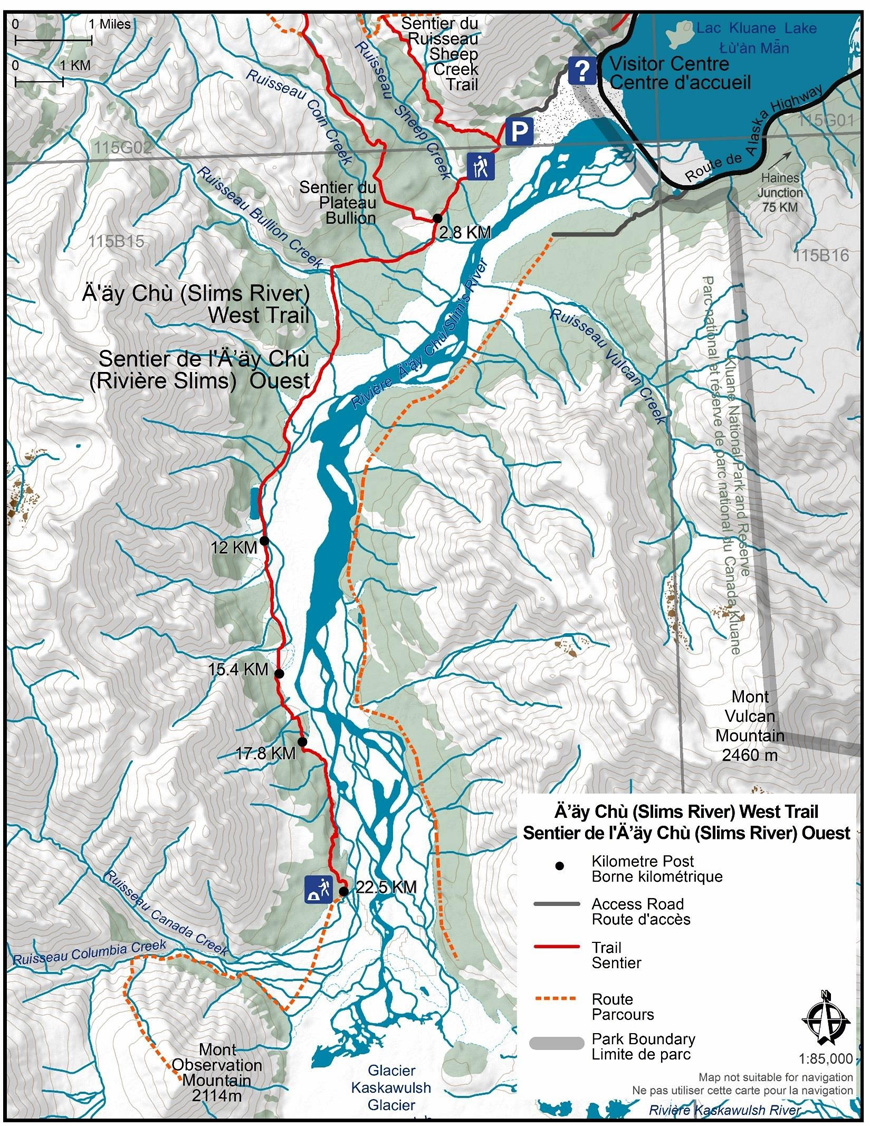
Trailhead: Thechàl Dhâl trailhead parking lot, 2.6 km (1.6 mi) up the Ä’äy Chù (Slims River) Valley from the Thechàl Dhâl Visitor Centre.
Topo map (1:50,000): Slim's River 115 B/15
In summary
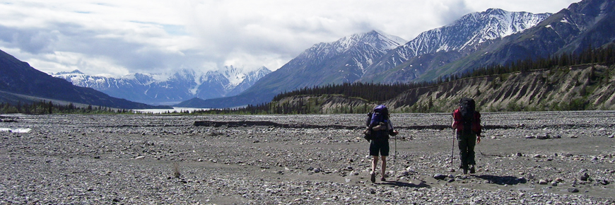
This trail follows a maintained hiking trail for 22.5 kms along the west side of the Ä’äy Chù (Slim’s River) to Canada Creek. The trail ends at the Canada Creek primitive campsite, but most hikers continue along a route that climbs to the plateau or to the top of Observation Mountain. This popular route has wonderful views of the Kaskawulsh Glacier. Although the Ä’äy Chù Valley trail is relatively easy to follow, the climb up Observation Mountain is long and demanding, requires route-finding skills, and is thus classified as difficult.
Download the Ä’äy Chù West trail / Observation Mountain route description (PDF, 925 Kb)
The details
-
Ä’äy Chù (Slim's River) West trail
After registering at the Thachäl Dhäl Visitor Centre, drive or hike 2.6 km to the parking area at the trailhead. Follow the old mining road and cross Sheep Creek. At 2.8 km the Bullion Trail exits to the right and the road narrows to a trail. Cross the boardwalk through a marshy area of Coin Creek and continue on to Bullion Creek where the 5.8 km post is visible. Camping prior to Bullion is not recommended in order to protect cultural resources in the area; however, the Bullion Creek alluvial fan is one of three that are recommended for safer camping (should you not be able to reach the camp ground at Canada Creek in a single day). Refer to the “Hiking & Camping Safely in the A’ay Chu Valley” pamphlet to learn more about alluvial fans and debris flows.
Crossing Bullion Creek can be difficult in the afternoon or after it has rained or snowed. You may have to cross further downstream where the creek is braided and work your way back up to the trail. Pick up the trail on the other side of Bullion and continue south below the embankment for about 2.5 km where multiple footpaths converge around the base of the Bullion sand dunes (look for the 8km post). Please do not camp in these dunes as this is a Special Preservation Area with fragile soil and vegetation.
There are two options for the next 6 km. If it is dry in the valley you can travel on the river flats, which is easier, but there will be a few extremely muddy creek crossings. This route choice is not recommended early in the season or after a lot of rain. If it is wet, follow stable ground closer to the mountains.
After passing a pond around the 11 km mark, you will come to a small alluvial fan at km 12. This is the second preferred camping area along the trail. Cross the next fan at km 13 by following posts and the trail. Marker posts direct you into the trees and uphill through the forest. This bypass route takes you around a very marshy section.
Follow the trail to the large alluvial fan at km 14.3 on the pamphlet map—this is the third and last of the preferred camping areas along the trail. Rock cairns will lead you directly across the fan: look for a path that is lined with rocks leading through a brushy section of stunted spruce trees. You will pass the 15.4 km marker as you drop off the fan. Continue to follow the obvious trail through the forest for the next 1.5 kms.
Exiting the forest you reach another small fan at 17 km. Posts and rock cairns direct you high on the fan to where it drops down at the 17.8 km post. The trail climbs around a marshy area and continues through the forest crossing another debris flow. You emerge at a boardwalk at km 18.5.
The trail now climbs up steep hills and follows a narrow path above the cliffs. It is the most difficult section of the trail and can make for a long end of the day. Do not try to travel along the river on this section as the trail avoids hazardous areas of quick mud. After climbing to the 21.2 km post, the trail descends down to the primitive campsite and the 22.5 km post on the flats.
-
Observation Mountain route
Distance: 19 km (12 mi) return trip
Time: 1-2 days
Elevation gain: 1,291 m (4,235’)
Maximum elevation: 2,114 m (6,300')A route is not a trail
Routes are not marked with signs or maintained in any manner. The route described here is only a suggestion that may help guide you on your trip. Self-reliance and wilderness travel experience are essential, including excellent route finding skills, map and compass skills. It is the responsibility of individual hikers who choose to follow such routes to adequately prepare and be prepared to rely on themselves.From the primitive campsite, travel south towards the toe of the Kaskawulsh glacier. You will reach the section of Canada Creek where it braids as it enters the Ä’äy Chù River. This is often the best place to cross. Aim for a 6x6 post in the middle of the delta, which will lead you in this direction.
After crossing Canada Creek, head west towards the base of Observation Mountain then continue west (upstream) up Canada Creek, until you get to Columbia Creek flowing out of the southwest into Canada Creek (about 4 kms). The cliffs around Columbia Creek are very good places to see mountain goats. Follow along the left side of Columbia Creek for a short distance (about 500-800 m) until you notice a game trail heading up the slope to your left, just prior to a cliff face that drops down to the creek. The trail starts a few feet above the creek bed due to recent erosion so may be easy to miss. Follow this game trail up onto a steep narrow ridge into the alpine. This is one of the easier routes up onto Observation Mountain.
Remain on the ridges for the ascent and especially on your descent off the mountain (remember which ridge you ascended for your hike back down). This route will take you to a large open alpine saddle or plateau. Continuing due south to the end of the plateau will bring you to a spectacular view of the South Arm of the Kaskawulsh Glacier. To the east is the peak of Observation Mountain from which there are panoramic views of the Ä’äy Chù and Kaskawalsh Valleys. It is not necessary to climb right to the top Observation for a view of the Kaskawulsh glacier as it can be seen from the edge of the plateau. It is best to return via the same ridges recommended for the ascent.
What you need to know
The primitive campground is used heavily so please minimize your impact on this area. There is an outhouse and water from a nearby stream. Campfires are not allowed. Tents may be set up in the cleared areas in the trees or in the trees near the outhouse. Please use established trails to prevent erosion and damage to fragile vegetation.
Unfortunately, cases of giardia have been reported in the Ä’äy Chù Valley, so water boiling, tablets or filters are recommended. Good boots are useful for Observation Mountain and gaiters are handy for the alpine snow and deep mud on some of the flats; a hiking pole is recommended for descending Observation Mountain and is useful for creek crossings.
Creeks in the valley will vary in size dramatically even over the course of a day (especially in spring) and as a general rule creeks are lowest and easiest to cross in the early morning; see Park staff for more information on creek crossings.
For all overnight trips in the park Approved Bear Resistant Food Canisters are mandatory and a Wilderness Permit is required, both can be obtained from the Kluane National Park and Reserve Visitor Centre in Haines Junction or the Thechàl Dhâl Visitor Centre. For more information: Overnight registration.
Bear sightings are common in this area. Review recommendations for travel within the You Are In Bear Country brochure. All bear sightings should be reported to the staff at one of the Visitor Centres.
Parks Canada 24 hour emergency dispatch
1-780-852-3100
Cellular telephones do not work in most of the park. Satellite phones or satellite messaging devices are strongly recommended.
Using a topographic map at a 1:50,000 scale is highly recommended: Slim’s River / Ä’äy Chù 115 B/15.
Related links
- Date modified :