

Maps
Thaidene Nene National Park Reserve
For reliable maps of the Thaidene Nene National Park Reserve, the 1:50,000 scale National Topographic System (NTS) maps series are recommended. For navigating on Great Slave Lake ensure that you have all the relevant nautical charts.
Visitors should determine which maps and/or charts they require and obtain them before exploring the National Park Reserve.
-
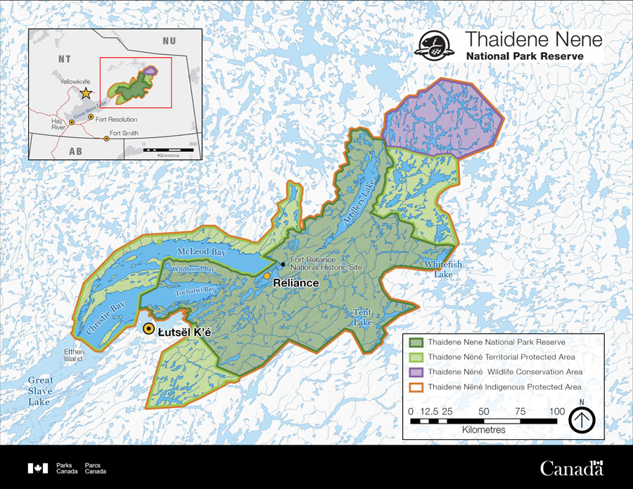
Thaidene Nëné Indigenous Protected Area (National Park Reserve and Territorial Protected Area)
Thaidene Nene National Park Reserve is part of the Thaidene Nëné Indigenous Protected Area as designated by the Łutsël K’é Dene First Nation, which includes the adjacent Thaidene Nëné Territorial Protected Area.
Thaidene Nëné map (3300 x 2550px PDF 700 KB)
-
Thaidene Nene National Park Reserve Key Features Map
There is so much to see and do in Thaidene Nene National Park Reserve. Use this map (PDF 25.6 MB) to orient yourself to the main areas in the park. These maps are for initial planning purposes and are not intended for navigation.
Thaidene Nëné map (PDF 157,797 KB)
-
1:50,000 Maps
There are 37 maps that cover the national park reserve. You can use the NTS map index to determine what maps you need.
-
1:250,000 Maps
The following 1:250,000 scale topographical maps are useful for general route planning or area reconnaissance. These maps have less detail compared to 1:50,000 scale maps, but they cover more area. There are five maps that cover Thaidene National Park Reserve. You can use the NTS map index to determine what maps you need.
1:250,000 scale NTS maps
- 075K Reliance
- 075J Lynx Lake
- 075L Snowdrift
- 075N Walmsley Lake
- 075O Artillery Lake
-
NTS maps and GPS receivers
Hikers and paddlers often use handheld GPS devices in conjunction with the NTS maps to navigate. Many of the NTS maps use an older datum called North American Datum 1927 (Nad27). GPS receivers utilize the World Geodetic System 84 (WGS 84) datum. If your map utilizes a datum other than WGS-84 you must transform the GPS coordinates to the datum used by your map, or you may incur a navigational error in excess of 200 meters. For more information regarding map datums search for “Map Datum” on the Natural Resources Canada Web site.
-
Where to Get Topographic Maps
Please refer to the Natural Resources Canada’s Map page to find where to purchase maps for Thaidene Nene National Park Reserve. Digital versions of the 1:50,000 NTS maps are also available on the Natural Resources Canada website.
-
Nautical Charts
Chart 6341 (Great Slave Lake East) is what you need to navigate in Thaidene Nene National Park Reserve if boating on Great Slave Lake. Visit the Canadian Hydrographic Service to see the full listing of nautical charts needed to navigate from your point of departure to the National Park Reserve, including information about how to purchase charts.
-
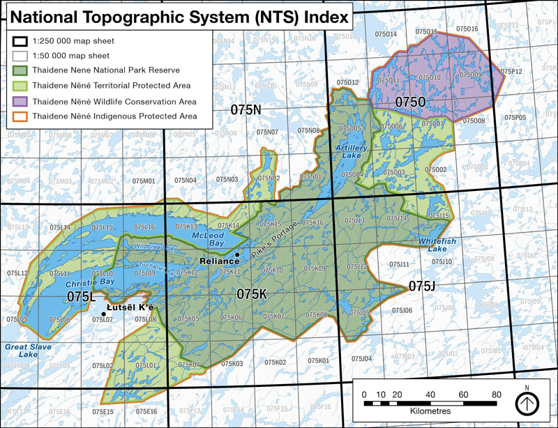
NTS Map Index
You can use the NTS map index superimposed on the national park boundary to determine what maps you need.
NTS map index (3253 x 2496 PDF 765 KB)
-
Park Boundary for Google Earth
Download this KML file and open it in Google Earth to see the park boundary.
Park Boundary for Google Earth (KML 242 KB)
-
Park Boundary for GPS
Do you need the park boundary for your GPS unit? Download this GPX file. (GPX 3.0 MB)


We have several map products available and are working on creating more. Is there a map you would like? Contact us.
- Date modified :