
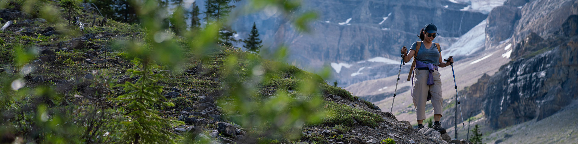
Day Hikes
Kootenay National Park
In the mountains, trail conditions can change quickly. Find the latest trail condition reports and closures for Kootenay National Park. Be sure to check back often for up-to-date information.
Challenge yourself on the Kindersley-Sinclair Loop through alpine meadows and over mountain ridges, or set out on an ambitious day hike through naturally fire-swept forest to the active Stanley Glacier.
For maps, detailed route finding and trail descriptions, visit the Kootenay Visitor Centre or purchase a hiking guide book and topographical map.
Safety
Safety is your responsibility. There are always hazards associated with outdoor recreation. Even short trips can have serious consequences. Minimize your risk by planning ahead.
- Check the weather forecast, current trail conditions, warnings and closures or visit a Parks Canada visitor centre.
- Be prepared for emergencies and changes in weather. Mountain weather changes quickly and it can snow any month of the year. Dress in layers, bring extra food and warm clothing.
- Study descriptions and maps before heading out. Always choose a trail suitable for the least experienced member in your group.
- Bring your own water. Surface water may be contaminated and unsafe for drinking.
- Carry a first aid kit and bear spray.
- Tell a reliable person where you are going, when you will be back, and who to call if you do not return: Parks Canada Dispatch – 403-762-1470.
- Ticks carrying Lyme disease may be present in the park. It is important to check yourself and your pet after hiking.
- Avoid wearing earbuds or headphones. Be alert at all times.
- In case of EMERGENCY, call 911 or satellite phone: 403-762-4506. Cell phone coverage is not reliable throughout the national park.
Snowy trails
Snow can remain on some trails well into the summer. When trails are snow covered, route finding can be difficult and travel through deep snow or on hard snow and ice can be unsafe. Be prepared and check trail conditions before heading out.
Seasonal avalanche risk

Trails above tree line (2,000 m) may be exposed to avalanche hazard at any time of the year and especially from November through June. Steep slopes that are snow covered have the potential to avalanche. For more information on the avalanche hazard, visit a Parks Canada visitor centre or check the Mountain Safety section.
Recommended Packing List
- Trail guide and map
- Full water bottle or thermos
- High energy food
- Bear spray
- Sunscreen and sunglasses
- First aid kit
- Headlamp or flashlight with spare batteries
- Hat and gloves
- Hiking poles
- Rain/wind jacket
- Extra warm clothing in case of an emergency
- Cell phone or satellite emergency communication device.
Trail Etiquette
Show courtesy to fellow trail users!
- Leave what you find —it is the law. Natural and cultural resources such as rocks, fossils, artifacts, horns, antlers, wildflowers and nests are protected by law and must be left undisturbed for others to discover and enjoy.
- Dispose of human waste at least 100 m from any water source. Bury solid human waste in a hole 15 cm deep. Pack out your toilet paper.
- To prevent damage to vegetation, stay on designated trails at all times.
- Trails are used by a variety of outdoor enthusiasts. Be sure to yield to others.
- Leave no trace. Pack out everything you pack in.
Wildlife and people

Kootenay National Park is home to wildlife including elk, wolves, cougars, grizzly bears and black bears. To successfully raise their young and sustain a healthy population, wildlife need access to as much quality habitat with as few human surprises as possible.
Be aware of possible encounters with wildlife in all areas of the park, including paved trails and roads.
Tips
- Always carry bear spray, ensure it is accessible, and know how to use it before heading out.
- Make noise. Being quiet puts you at risk for sudden wildlife encounters. Be alert through shrubby areas and when approaching blind corners. Travel in tight groups and always be aware of your surroundings.
- Report bear, cougar, wolf and coyote sightings and encounters to Parks Canada Dispatch when it is safe to do so: 403-762-1470.
- Keep dogs on leash and under control at all times.
More information
Trail Ratings
|
Easy |
|
|
Moderate |
|
|
|
|
| Estimated time to complete these trails ranges depending on trail distances, fitness levels, weather and trail conditions. | |


Map: Kootenay Trail Guide
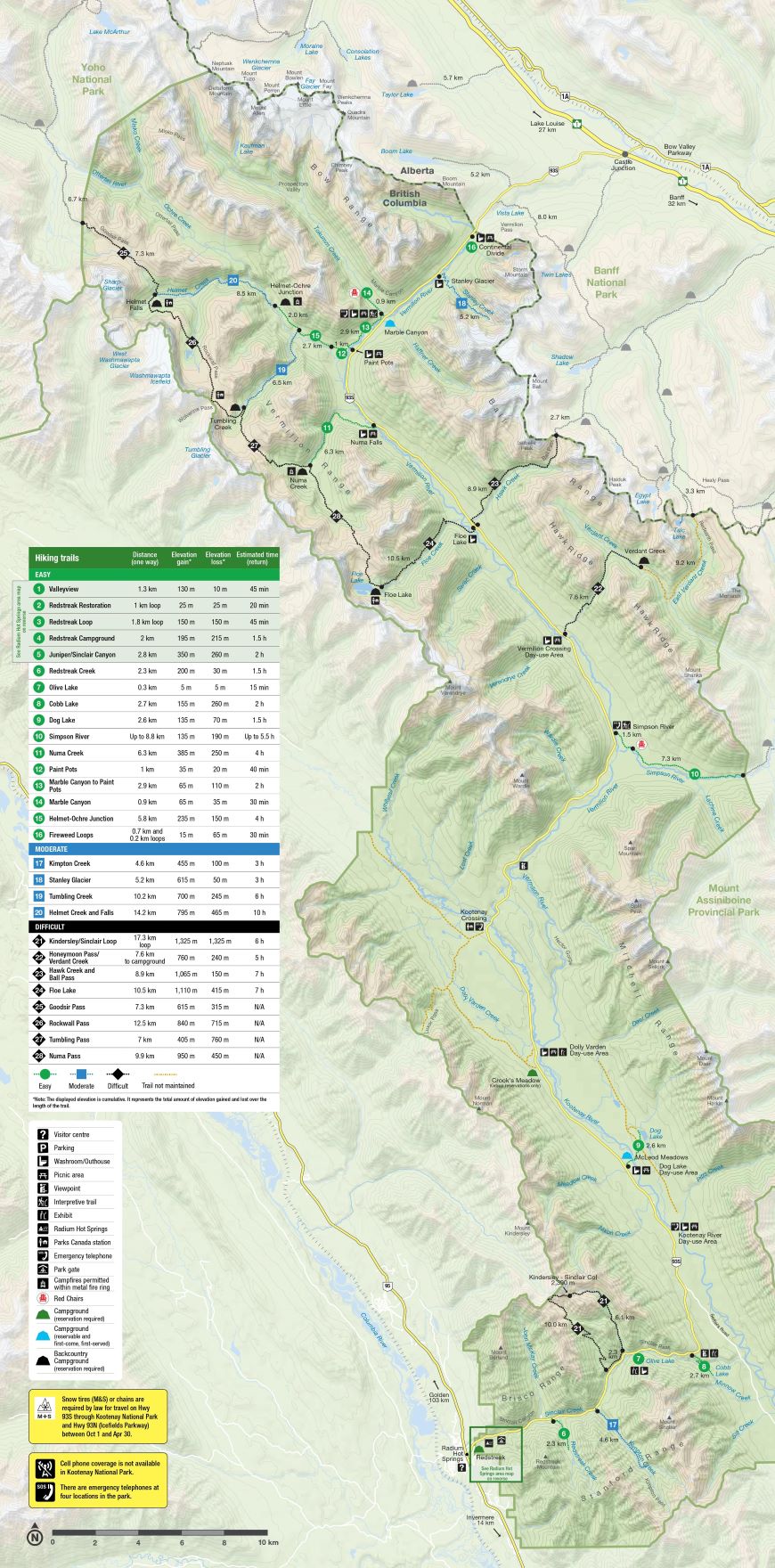
| Trail | Distance (one way) | Estimated Time (return) | Elevation gain* | Elevation loss* |
|---|---|---|---|---|
 Helmet - Ochre Junction
 |
5.8 km | 4 hours | 235 m | 150 m |
| Simpson River |
8.8 km | Up to 5.5 hours | 135 m | 190 m |
 Stanley Glacier Stanley Glacier |
4.4 km | 3 hours | 385 m | 40 m |
| Kimpton Creek |
4.6 km | 3 hours | 455 m | 100 m |
 Numa Creek Numa Creek
|
6.3 km | 4 hours | 385 m | 250 m |
| Kindersley / Sinclair Loop |
17.3 km loop | 6 hours | 1,325 m | 1,325 m |
| Hawk Creek & Ball Pass |
8.9 km | 7 hours | 1,065 m | 150 m |
| Floe Lake |
10.5 km | 7 hours | 1,110 m | 415 m |
*Note: On most hiking trails you will gain and lose elevation before you reach your destination. Elevation gain represents all the up and elevation loss all the down you will experience on a one-way hike.
Trail Descriptions
 Easy trails
Helmet - Ochre Junction
Length (one way): 5.8 km
Estimated time (return): 4 hours
Elevation gain: 235 m | Elevation loss: 150 m
Trailhead: Paint Pots parking lot, 84 km east of Radium Hot Springs.
Habitat: Forested trail with lush ground cover leading to a river.
Description: A good backpacking destination for beginners through lush forest. Alternatively, a 4-hour day hike.
Backpacking: This trail leads to the Helmet / Ochre Junction backcountry campground. It is the northernmost access point for the popular Rockwall multiday backpacking route.
Simpson River
Length (one way): Up to 8.8 km
Estimated time (return): 5.5 hours
Elevation gain: 135 m | Elevation loss: 190 m
Trailhead: Simpson River parking lot, 57 km east of Radium Hot Springs.
Habitat: Forested trail near a three valley confluence. Watch for evidence of wildlife.
Description: A walk through a valley marked by fire. Check out the interpretive signs along the first 1.5 km of the trail. Learn about the incredible forces of nature: Lightning, wildfire, regeneration and succession.
Backpacking: This trail leads into Mount Assiniboine Provincial Park in British Columbia.
 Moderate trails
Stanley Glacier
Length (one way): 4.4 km
Estimated time (return): 3 hours
Elevation gain: 385 m | Elevation loss: 40 m
Trailhead: Stanley Glacier parking lot, 91 km east of Radium Hot Springs.
Habitat: Regenerating forest, glacier, glacial moraine, cliffs, many small mammals. Watch for fossils.
Description: An extremely popular trail. Hike up to a stunning alpine basin and watch glacier meltwater tumble down massive rock walls. You can also experience this trail on a guided Burgess Shale fossil hike.
Kimpton Creek
Length (one way): 4.6 km
Estimated time (return): 3 hours
Elevation gain: 544 m | Elevation loss: 100 m
Trailhead: Kimpton Creek parking lot, 9 km east of Radium Hot Springs. From the parking pullout, walk 100 m south-west along the highway and cross a small footbridge to start the trail.
Habitat: Forested trail with prominent avalanche slopes. Watch for bears.
Description: A cool forested trail on a hot day.
 Difficult trails
Numa Creek
Length (one way): 6.3 km
Estimated time (return): 4 hours
Elevation gain: 385 m | Elevation loss: 250 m
Trailhead: Numa Falls parking lot, 80 km east of Radium Hot Springs.
Habitat: Forested, creekside trail opening into prominent avalanche paths.
Description: A shaded creekside trail.
Backpacking: This trail leads to the Numa Creek backcountry campround and is a middle access point for the popular Rockwall multiday backpacking route.
Note: This trail gets heavily impacted by avalanche debris year-round and may be closed. Check the trail report for updates.
Kindersley – Sinclair Loop
Length (one way): 17.3 km
Estimated time (return): 6 hours
Elevation gain: 1,325 m | Elevation loss: 1,325 m
Trailhead: Kindersley Pass parking lot, 12 km east of Radium Hot Springs OR Sinclair Creek parking lot, 11 km east of Radium Hot Springs.
Habitat: Forested trail with avalanche slopes and rocky ridges. Watch for bears.
Description: A classic. Travel through a mixed landscape of forest, avalanche paths, alpine meadows and rocky ridges. A 1.2 km section on the highway completes the loop.
Be advised: Mandatory minimum group size of four because of grizzly bears in the area. Check the Trail Report.
Hawk Creek and Ball Pass
Length (one way): 8.9 km
Estimated time (return): 7 hours
Elevation gain: 1,065 m | Elevation loss: 150 m
Trailhead: Floe Lake parking lot, 72 km east of Radium Hot Springs.
Habitat: Regenerating, post-burn forest.
Description: A challenging day hike to a rocky, rugged pass providing access to the Shadow Lake and Egypt Lake regions of Banff National Park.
Backpacking: This trail leads to backcountry camping in the Shadow Lake area of Banff National Park.
Floe Lake
Length (one way): 10.5 km
Estimated time (return): 7 hours
Elevation gain: 1,110 m | Elevation loss 415 m
Trailhead: Floe Lake parking lot, 72 km east of Radium Hot Springs.
Habitat: Open and meadowy trail, burnt forest, glaciers, peaks and a large lake.
Description: One of the most popular day hikes in the park. Steep trail with sunny exposures and views along the way. Spectacular lakeside destination.
Backpacking: This trail leads to the Floe Lake backcountry campground and is the southernmost access point for the popular Rockwall Trail, multi-day route.
Related links
- Date modified :