
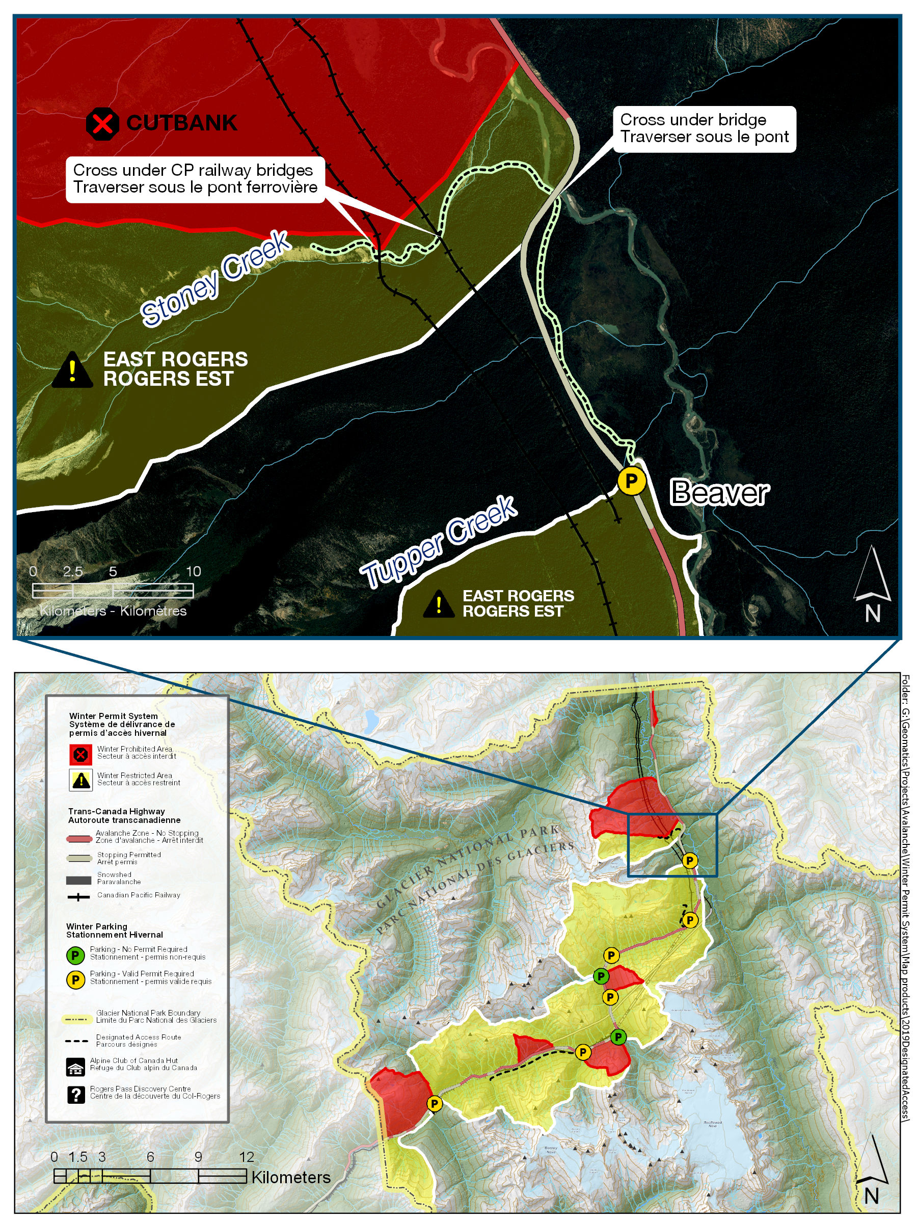
Designated access routes
Winter
Public safety is Parks Canada’s primary concern. Access to the following areas has been established via routes that avoid crossing Canadian Pacific property. Canadian Pacific Police patrol these sites and may tow and impound vehicles illegally parked on railway property. Individuals trespassing on Canadian Pacific Railway property will be prosecuted.
Shaughnessy Winter Restricted Area - from Beaver Parking
A valid Winter Permit is required to enter a Winter Restricted Area. Note that this route passes through avalanche terrain. Permit holders must use safe travel precautions appropriate to the current avalanche danger.
To access the Shaughnessy Restricted Area, permit holders must park at the Beaver Valley Winter Parking Area.
- From the parking lot, follow the summer road downhill for ~150m. Look on the left side of the road for orange markers to find the route that heads north towards the Beaver River.
- Follow the cleared route until you reach the Beaver River.
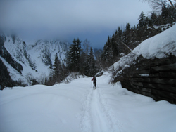
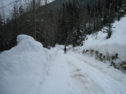
- Turn left heading upstream along the Beaver River (photo), and travel under the highway bridge. As you approach the bridge listen for snowplows, they can spray snow and gravel a far distance off the bridge. Don’t approach if you hear plows and travel through this area quickly.
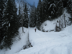
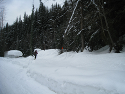
- After passing under the bridge leave the river, following the marked route (photo).
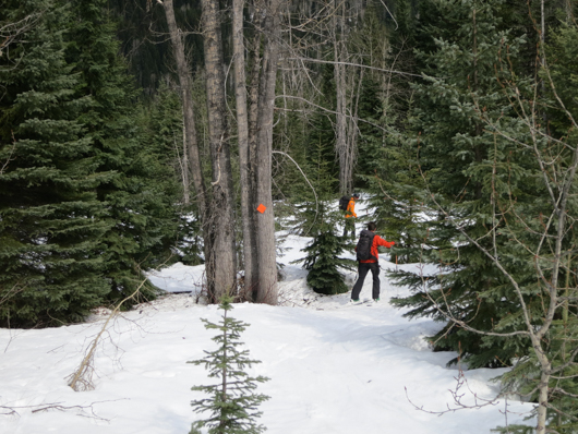
- When you reach Stoney Creek continue upstream, heading SW (photo).
- When you reach the first CP Rail bridge cross stoney creek, and pass under the bridge/ CP tracks trending slightly to the right (photos) to find the marked route continuing up the shoulder on the climbers right side of Stoney Creek.
- Continue to follow the marked route, heading uphill generally following the shoulder above the Stoney Creek drainage until you reach the upper CP Rail Bridge (photo A). Drop down slightly to travel under the bridge and then follow the route back up to once again gain the shoulder (photo B).
A.
B.
- Continue travelling up along the shoulder.


Shaughnessy DAR for egress from N Swiss
- At ~1350m, and before the creek gulley constricts, exit the Stoney Creek drainage to the north, traversing the slope to the skiers left (see photo A).
Follow the shoulder down until you are just above the first set of train tracks (see photo B)
Photo A.
Photo B.
- Descend to the skiers right (see photo), travel under the bridge, and then climb back up to gain the shoulder again.
- Continue down the shoulder to an elevation ~940m, then travel to the skiers right (south) following a line of orange markers (photo) until you reach Stoney Creek. Follow the creek under the train bridge.
- Continue down the creek on the skiers right (south) side for ~350m. Leave the creek and follow orange markers (photo) to reach the Beaver River.
- When you reach the Beaver River turn right, heading downstream, and travel under the highway bridge. As you approach the bridge listen for snowplows, they can spray snow and gravel a far distance off the bridge. Don’t approach if you hear plows and travel through this area quickly.
- After passing under the bridge look to the right for orange markers showing where the route leaves the river. Follow the well marked trail for ~2km to reach the designated parking area.


East Rogers Winter Restricted Area - Mount Tupper from Stone Arch Parking
A valid Winter Permit is required to enter a Winter Restricted Area. Note that this route passes through avalanche terrain. Permit holders must use safe travel precautions appropriate to the current avalanche danger.
Parking at the Stone Arch Gun Position is only permitted when the permit area is posted open for that date, and only to holders of a valid Winter Permit.
- Route length ~2.74 km.
- Numbers refer to images.
Access Route
To access East Rogers Restricted Area (i.e. Connaught Slide Path), permit holders must park at Stone Arch Parking. From the parking area, follow the marked trail (1) leading southwest (towards Rogers Pass), between the Trans Canada Highway and the CPR tracks. After travelling ~600 metres through the forest the trail comes to an opening that heads down and crosses over where the tracks enter the Connaught Tunnel (2). Once over the tunnel, continue west (uphill) ~ 100m along the access road (3). Immediately beyond Cascade Creek, an orange marker indicates where the route heads upslope for 100 metres to an abandoned railgrade. Once on the rail grade, turn right and head NE along the rail grade. Beyond this point, permit users may choose their own route, keeping at least sixteen metres from the CP rail property (6-8).
Exit Route
At approximately 1160m (8), permit holders finishing the Tupper traverse will reach the abandoned rail grade. At this point, turn right and head southwest along the rail grade (7). Continue along the rail grade for approximately 1 km, travelling through a series of avalanche paths. After crossing over the historic CPR Stone Arch bridge (6) the route begins to head downhill, continuing along a well cleared grade (5) until reaching a large orange marker on a tree on the left hand side of the trail (4). At this point, turn left and head downhill for ~100 metres through a clearing until reaching the CPR access road. Turn left on the access road (3) and travel along it for ~100 metres, watching for a bright orange marker on the right (2). At the marker, and before the portal of the Connaught Tunnel, head right and up into the trees and follow the orange markers through the forest keeping at least sixteen metres from the CP rail property. Follow the trail through the forest (1) that leads northeast between the Trans Canada Highway and the CPR tracks until reaching Stone Arch Parking (~600 metres).

Designated Access Route to Connaught Slide Path in East Rogers Winter Restricted Area
Images shown as per Exit Route description.

8) At ~1160m travel SW on the abandoned railgrade.
7) Travel along railgrade.
6) Cross the Stone Arch.

5) Head downhill along the old grade.

4) Leave the old grade and head downhill.
3) Turn left and travel on the CPR access road.
2) Turn right travelling over the tunnel entrance.

1) Follow the marked route to Stone Arch Parking.
West Rogers Winter Restricted Area - Ross Peak from Loop Brook Parking
A valid Winter Permit is required to enter a Winter Restricted Area. Note that this route passes through avalanche terrain. Permit holders must use safe travel precautions appropriate to the current avalanche danger.
Designated parking is available at the winter parking area for Loop Brook, located 6.7 kilometres west of the Rogers Pass Discovery Centre and is only permitted when the permit area is posted open for that date.
Access: From the Loop Brook parking area, cross Loop Brook and travel west, paralleling the south side of the Trans Canada Highway (TCH). After ~350m, before the 2nd bridge, and when across from the Loop Creek Gun Position (GP10), begin contouring around the shoulder of Ross Peak. A good visual reference is the gun aiming post (GAP) in the trees on the Ross Peak side of the TCH. Continue contouring, keeping at least 16m away from the train tracks, until the tracks cross the Illecillewaet River, at which point permit users may choose their own route.
Exit: Keeping to the south side of the Illecillewaet, travel east until approaching the train tracks. At this point, users must contour the shoulder of Ross peak, keeping at least 16m away from the train tracks. Once the tracks cross under the TCH (a good visual is the GAP), permit users may descend and safely parallel the TCH to return to the Loop Brook parking area.

Designated Access Route to Ross Peak in West Rogers Winter Restricted Area
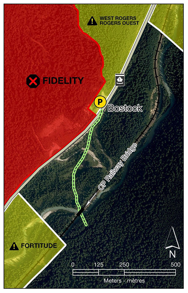
Flat Creek Winter Unrestricted Area, Fortitude and West Rogers Winter Restricted Areas - from Bostock Parking
A valid Winter Permit is required to enter a Winter Restricted Area. Note that this route passes through avalanche terrain. Permit holders must use safe travel precautions appropriate to the current avalanche danger.
The CP bridge and tracks are Canadian Pacific Railway property, do not trespass. Note that no bridge is available for foot travel across the Illecillewaet River. At times, a safe crossing may not be available. Please use caution and choose a safe route.
- From Bostock Parking, carefully cross to the southeast side of the Trans-Canada Highway (TCH).
- Travel southwest parallel to the highway (towards Revelstoke) for 25m until you see a tree with an orange marker. From that point, ski down the bank diagonally, aiming towards Fortitude ridge and the CP access road. Follow the orange markers to the CP access road (about 150m).
- Cross the unplowed access road and travel in a southwesterly direction, into a flat opening, just left of a large, marked hemlock tree.
- From there, parallel the TCH and follow the markers for about 250m towards the end of the open meadow. Before the end of the open meadow, trend south (left), following the markers towards the thicker forest.
- Follow a cleared marked trail through the trees. Stay on this trail, until you get to the train bridge at the Bostock Creek and Illecillewaet River confluence.
- Cross under the tracks by walking or skiing under the CP train bridge. Do not trespass on the bridge. If available, find a safe snow or ice bridge to cross the Illecillewaet River. At times, a safe crossing may not be available. Please use caution and choose a safe route.
- Date modified :