
© Natalie Harris
Weather and climate
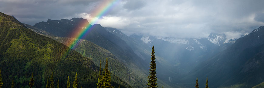
Glacier National Park
Glacier National Park is situated in the Columbia Mountain Range, and is part of the Interior Wetbelt region of British Columbia. It is characterized by heavy annual precipitation, abundant snowfall and relatively moderate winter temperatures. The weather of the Glacier National Park region develops as a result of warm moisture-laden air from the Pacific being deflected upwards by the Columbia Mountains. Decreasing pressures, expansion and cooling of the air masses result in high precipitation over the Columbia Mountains. Most moisture falls as snow in Glacier National Park. The usual snow season is from mid-October to mid-June, but snow can fall at any time of year at higher elevations. The mean annual precipitation is 1278mm (50in) at Revelstoke, 1995mm (79in) in the subalpine zone.
The variations in daily weather reflect the large variations in regional topography throughout the Columbia Mountains. For example, it may be raining hard in one valley, while the adjacent valley may be under sunny skies. Weather forecasting, therefore, tends to be unreliable except when air masses are large and stable, which is a rare occurrence in this region of British Columbia.
The park receives regular regional weather reports, including fire and lightning forecasts, direct via electronic mail from the Environment Canada facilities in Kelowna, B.C. Daily weather reports and predictions for Revelstoke, BC and Golden, BC are available from Environment Canada.
In Glacier National Park, the summers (July - September) and winters (December - February) are the most suitable for recreation (hiking, walking, picnicking, camping, cross-country skiing, ski touring, snowshoeing). The transition months of April/May and October/November are less suitable for recreation due to factors such as excessive or insufficient snow, although April can sometimes provide excellent weather and snow conditions for ski touring. Only a few of the lowest-elevation trails in the park will be snow-free in most Junes.
Heavy winter snowfalls (up to 17 metres at Rogers Pass, resulting in a two-metre-deep snowpack) result in extreme avalanche activity at times, which presents a significant public safety hazard. Daily highs and lows tend to be 5 to 10 degrees Celsius lower in Glacier National Park than in Mount Revelstoke National Park. Glacier also receives substantially more rain in summer and snow in winter than does Mount Revelstoke.
Rogers Pass climate averages (elevation 1330m / 4360 ft)
The following tables outline what to expect from our climate throughout the year. These are averages. The time of snowmelt or wildflower blooming can vary each year, by as much as several weeks!
| Averages | Daily High (°C) |
Daily Low (°C) |
Rainfall (mm) |
Snowfall (cm) |
Days of precip. |
|---|---|---|---|---|---|
| Jan | -7 | -11.8 | 8.9 | 215.4 | 26.1 |
| Feb | -3.4 | -9.6 | 4.9 | 147 | 21.1 |
| Mar | 1.6 | -6.5 | 22.1 | 110.3 | 22.5 |
| Apr | 6.6 | -2.9 | 36 | 41 | 18.0 |
| May | 11.3 | 0.2 | 65.4 | 6.6 | 17.9 |
| Jun | 16.7 | 4.1 | 90.7 | 0 | 18.3 |
| Jul | 20.7 | 6.3 | 87.3 | 0 | 16.1 |
| Aug | 20.2 | 5.9 | 84.3 | 0.0 | 15.4 |
| Sep | 13.7 | 2.7 | 100.5 | 1.5 | 15.7 |
| Oct | 4.9 | -1.3 | 96.2 | 47.7 | 20.1 |
| Nov | -2.7 | -6.6 | 34 | 167.2 | 24.4 |
| Dec | -7.2 | -11.4 | 6.7 | 195.8 | 27 |
| Month | Weather |
|---|---|
| January | Typically the snowiest month. Daily temperatures are below freezing at all elevations; mild Pacific air can produce rain showers; valley cloud obscures the sun at low elevations. |
| February | Winter conditions prevail. Temperatures are slightly milder. |
| March | Warmer temperatures bring more sleet and rain. At elevations above 1600 metres, snow has accumulated to depths of five metres or more. |
| April | Frequent sunny days and rising temperatures. |
| May | Temperatures are above freezing at all elevations. Rain is now the dominant precipitation and there is lots of sunshine. By the end of May the snow has usually disappeared from the lower half of Mount Revelstoke. |
| June | June is wetter than May and rainfall often increases. By the end of June in some years Rogers Pass and some of the Illecillewaet hiking trails will be snowfree. |
| July | Full summer prevails at the valley bottoms, in contrast to snowfields that usually still linger above treeline. By mid-July all hiking trails are usually snowfree. Parks Day events take place in mid-July. |
| August | August is the driest month of the year, on average. |
| September | Nights are cooler. There is greater likelihood of rain and, usually, snow. If the weather is fine, however, this can be the best time of the year for hiking. |
| October | Snow increases at higher elevations. By the end of the month, snow has come to stay in the high country. |
| November | Snow falls at all elevations. Avalanches may become active along the Trans Canada Highway. |
| December | Heavy snow accumulations and storms mark December. |
- Date modified :