
Geology and landforms
Waterton Lakes National Park
Geology is always changing! Forces throughout time shape and reshape the land into the unique forms found in Waterton Lakes and throughout the Crown of the Continent ecosystem.
Some of these forces like wind, rain and ice are seasonal, even daily occurrences, others like thrusts and glaciation occur over long periods of time.
Foundation
The rock layers in Waterton Lakes are primarily eroded sediments laid down particle by particle at the bottom of an ancient sea which existed 1,500 million years ago. Evidence of this ancient seabed is provided by fossilized ripple marks and salt crystal casts. These rock layers make up the park's geological foundation.
Mountain building
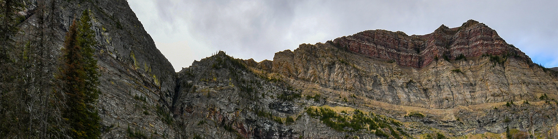
In most of the front ranges of the Canadian Rockies, mountains were built of overlapping, tilted thrust sheets. In Waterton Lakes, the main movement was a single, flat-lying thrust sheet originating about 100 km (65 miles) southwest of the mountains' present position. For millions of years, it slid northeast, more or less horizontally over younger 70 million year old Cretaceous rock. This fault is called the Lewis Thrust.
A brief history in time
Trying to imagine the age of the earth is a daunting task. The 1,500 million-year-old story of Waterton's landforms presents only one chapter of our planet's 4,600 million-year history!
We can form an idea of the relative duration of the earth's past by thinking of it compressed into one year [1 day = 12.6 million years]:
January 1 to September 1: Nothing much happened.
September 2: Waterton's rocks started to form.
By September 10: Waterton's rocks completely formed.
By November 14: The first animals evolved.
December 8 to 26: Dinosaurs roamed the Earth.
December 19: Plate movement compress the rocks of B.C.'s interior.
About December 24: Same forces began to compress Waterton's rocks.
December 26 to 29: Waterton's mountains reached their present location.
The evening of December 31: Humans, as a species, show up in the fossil record.
Erosion and deposition
Since the mountains were formed, glaciers and other forms of erosion sculpted and then deposited the pieces at their feet. Glacial and fluvial deposits blanketed the area east of the mountains, creating Waterton Lakes’ unique 'Where The Mountains Meet The Prairie' landscape.
Most of this landscape sculpting was done by mountain (cordilleran) glaciers. There are presently no glaciers in Waterton, just snow patches. Glacier National Park (in Montana) has several snowfields and about 50 small glaciers, which are retreating rapidly. At current rates of recession, they may be gone by mid-century.
However, the effects of glaciation are still obvious - deep, U-shaped and hanging valleys (eg. Upper Waterton and Akamina); cirques (e.g. Cameron Lake); kames (e.g. where the Prince of Wales Hotel sits) and eskers (e.g. in the bison paddock) are all found in Waterton Lakes National Park.
Every day, erosion continues to tear down mountains then deposit fragments to create new landscape features. Erosion has created land features such as the alluvial fans of Blakiston Creek and Red Rock Canyon.
Rock types in Waterton
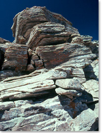
The park's unusual red and green rocks are shaly siltstones called argillite. The red rocks contain oxidized iron and the green rocks contain unoxidized iron. Beige/grey/brown rocks are limestone or dolomite. A noticeable black band seen on the face of some park mountains, called the Purcell Sill, is igneous rock.
Limestone
Limestone is the predominant group of rock formations found in Waterton Lakes. Limestone is a type of sedimentary rock composed mostly of the minerals calcite and aragonite, which are different crystal forms of calcium carbonate. Limestone forms when these minerals settle out of water containing dissolved calcium.
Stromatolites
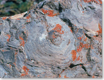
Rocks were formed at a time before the development of complex animal life on earth, so only fossils formed by primitive cyanobacteria are found. Some developed into impressive cabbage-like fossils called stromatolites.
"A stromatolite is a succession of thickened, domed-up layers. They are caused by colonies of cyanobacteria, previously called "bluegreen algae." Stromatolites are found in many formations of the Canadian Rockies, and they exist in tropical regions today. Living stromatolites in Shark Bay, Australia are identical to those found in the Siyeh Formation.”* This rock formation is found in Waterton Lakes National Park.
*This excerpt was kindly provided by Ben Gadd, from his Handbook of the Canadian Rockies 2nd edition (Corax Press, 1995, page 58).
Related links
- Date modified :