
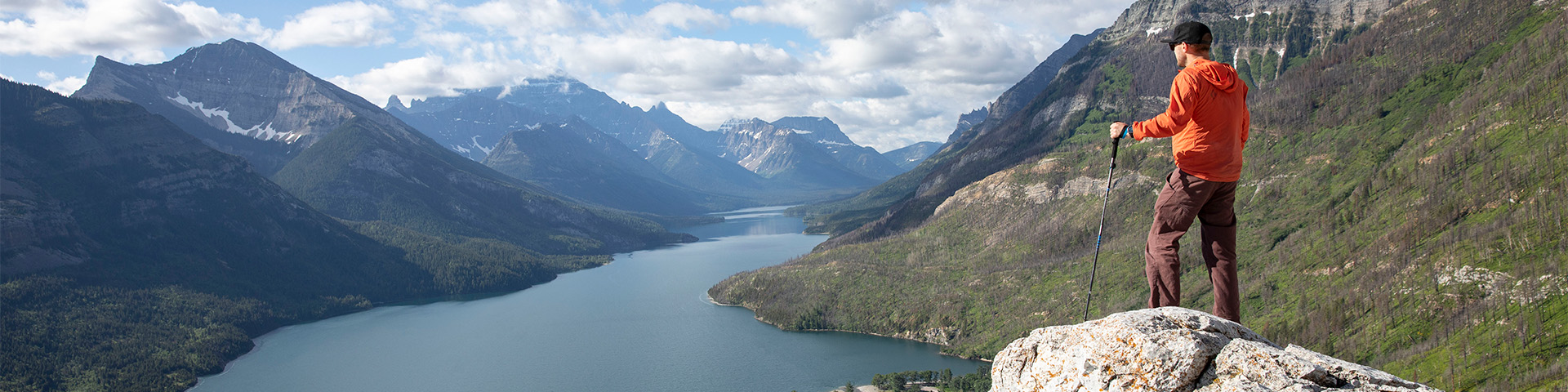
Hiking
Waterton Lakes National Park
There's over 200 kms of trails to explore in Waterton Lakes National Park. Short walks, day hikes even a multi-day trek are all available for you to explore.
The Bertha trailhead is in an avalanche path. Check the Bertha-Townsite avalanche advisory (updated daily) before accessing the area.
Short hikes and walks
Waterton Lakes National Park is a great place for short hikes and strolls
Day hikes
Waterton Lakes National Park has over 200 kilometres of trails offering great day hikes
Multi-day hikes
Information on hiking and backcountry camping adventures in Waterton Lakes National Park.
Trail conditions
Find current trail conditions at Waterton Lakes National Park
Seasonal road closures: Akamina Parkway is open to motor vehicles to Little Prairie day use area. Red Rock Parkway is closed to all motor vehicle traffic.
The park is a particularly good place to enjoy a variety of shorter trails which can be easily completed in a few hours or a day.
Begin by planning your trip. Make sure you have the knowledge, equipment and supplies to have a safe and enjoyable hike. Use the information below or stop by our visitor centre in the Waterton townsite.
Create your own experience - we'll take care of the scenery!
When to go
Prime hiking season runs July through mid-September. Until late June, many trails are still snow bound and may be subject to avalanche hazard.
Trails tend to be muddier at this time and the best hiking is at lower elevations or on drier, south-facing slopes. By the middle of July, most alpine passes are snow free.
Where to go
Use the trail information below to choose a hike suitable for everyone in your party.
Around town
| Trail | Distance (return) | Time |
|---|---|---|
 Kootenai Brown Kootenai Brown |
13.8 km (8.6 mi) | 0.5 to 2 hours |
| Linnet Lake Loop |
1 km (0.6 mi) | 20 minutes |
| Prince of Wales Loop |
2 km (1.2 mi) | 45 minutes |
| Townsite Loop |
3.2 km (2 mi) | 1 hour |
 Bear's Hump Bear's Hump |
2.8 km / 1.8 mi (return) | 1 hour |
| Crandell Lake (from townsite) |
12.4 km (7.7 mi) | 4 hours |
| Lower Bertha Falls |
5.2 km (3.2 mi) | 1.5 hours |
| Lakeshore |
13 km (8 mi), one way | 4 hours |
 Alderson-Carthew Alderson-Carthew |
20.1 km (12.5 mi), one way | 8 hours |
| Bertha Lake |
10.4 km (6.4 mi) | 4.5 hours |
| Crypt Lake |
17.2 km (10.7 mi) | 6 hours |
Akamina Parkway
| Trail | Distance (return) | Time |
|---|---|---|
| Akamina Lake |
1 km (0.6 mi) | 30 minutes |
| Cameron Lakeshore |
3 km (1.9 mi) | 1 hour |
| Crandell Lake (from Akamina Parkway) |
3.6 km (2.2 mi) | 1 hour |
| Akamina Pass |
3 km (1.9 mi) | 1 hour |
| Boundary Creek |
13.1 km (8.1 mi), one way (Summit Lake to Boundary Bay) | 4 hours |
| Lineham Creek |
8.4 km (5.2 mi) | 3 hours |
| Lower Rowe Lake |
8 km (5 mi) | 3 hours |
| Upper Rowe Lake |
12.8 km (8 mi) | 5 hours |
| Summit Lake |
8.6 km / 5.3 mi (one way) | 3 hours |
| Carthew-Alderson |
20.1 km (12.5 mi), one way | 8 hours |
| Tamarack (Akamina to Red Rock Parkway) |
32 to 36 km (20 to 23 mi) | 2 to 3 days |
Red Rock Parkway
| Trail | Distance (return) | Time |
|---|---|---|
| Blakiston Falls |
2 km (1.2 mi) | 45 minutes |
| Crandell Lake (from Red Rock Parkway) |
6.8 km (4.2 mi) | 1.25 hours |
| Red Rock Canyon Loop |
0.7 km (0.4 mi) | 20 minutes |
| Bellevue |
7.6 km (4.7 mi) | 2.5 hours |
| Blakiston Valley |
20.2 km (12.5 mi) | 7 hours |
| Lost Lake |
20.8 km / 10.2 mi (return) | 8 hours |
| Snowshoe |
16.4 km / 12.9 mi | 5 hours |
| Avion Ridge |
25 km / 15.5 mi | 10 hours |
| Goat Lake |
14 km (8.7 mi) | 5 hours |
| Lone Lake |
28 km / 17.4 mi (return) | 2 days |
| Twin Lakes |
22.8 km (14.1 mi) | 9 hours |
Eastern areas / Highway 6
| Trail | Distance (return) | Time |
|---|---|---|
| Horseshoe Basin |
21.3 km (13 mi) | 7 hours |
| Wishbone |
13.4 km (8.3 mi) to Vimy Junction (return), 14 km to Crypt Landing (one way) | 4 hours |
| Vimy |
26.2 km (16.3 mi) | 10 hours |
Trail ratings
|
Easy |
|
|
Moderate |
|
|
|
|


Guided hikes
Take a free guided hike with a Parks Canada interpreter (from June through September).
Interpretive trails
Our interpretive trails include information panels that tell a story about the park - the plants, wildlife and people that have shaped the area.
There are four trails with interpretive panels in Waterton Lakes National Park:
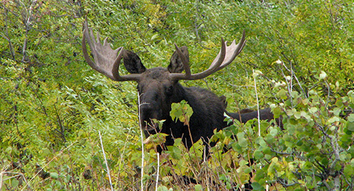
The chance to observe wildlife as they go about their natural lives is a fascinating experience. With this privilege comes the responsibility to treat wildlife with the respect they need and deserve.
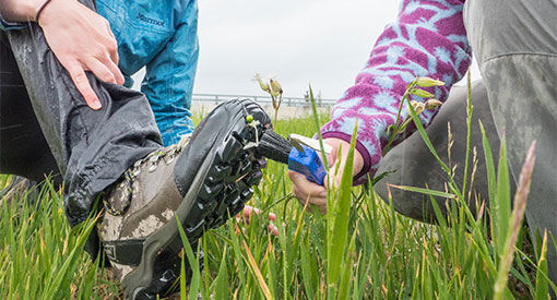
Waterton’s vulnerability to the spread of invasive plant species has increased as a result of the Kenow Wildfire. Visitors can help protect the landscape by remembering to Play Clean Go when hiking.
Staying safe
Be prepared
Hikers need to take individual responsibility for planning their trips and hiking safely. Even short trips from the Waterton townsite can have serious consequences. Minimize your risk by planning ahead.
Parks Canada provides information to help people understand and assess the risk so that they can make travel decisions. Make sure you have the knowledge, equipment and supplies to have a safe and enjoyable hike.
- Study trail descriptions and maps before starting.
- Check the weather forecast.
- Check current trail conditions and any trail cautions or closures.
- Consult our list of current infrastructure projects for potential impacts to your trip.
- Be prepared for emergencies and changes in weather.
- Choose a trail suitable for the least experienced member in your group.
- Pack adequate food, water, clothing, maps and gear.
- Carry a first aid kit and bear spray.
- Tell somebody where you’re going, when you’ll be back and who to call if you don’t return (call 911).
- Travel with a friend or group.
- Ticks carrying Lyme disease may be present in the park. It is important to check yourself and your pet after hiking.
Kenow Wildfire
Areas affected by the Kenow Wildfire may have increased hazards. These hazards may be triggered at any time with little or no warning.
Snowy and icy trails
Snow can remain on some trails until early summer. Travel through hard snow and ice can be unsafe. Be prepared and check trail conditions before heading out.
Avalanche risk
Much of the mountain area within Waterton Lakes National Park is avalanche terrain. Until late June, trails may be subject to avalanche hazard.
For more information about safety while enjoying Waterton Lakes National Park, see our visitor safety section.
Recommended packing list
- Trail guide and map
- Full water bottle or thermos
- High energy food
- Bear spray
- Sunscreen and sunglasses
- First aid kit
- Headlamp or flashlight with spare batteries
- Hat and gloves
- Hiking poles
- Rain/wind jacket
- Extra warm clothing in case of an emergency
- Cell phone or satellite emergency communication device.
Hiking etiquette
Our trails are shared by different types of users. Please be considerate of others and stay to the right of the trail to allow others to pass. As a best practice, hikers should yield to horseback riders, and cyclists should yield to both hikers and horseback riders.
Parks Canada encourages visitors who are planning to travel in the backcountry to practice Leave No Trace skills and ethics. Leave No Trace is a national program that promotes and inspires responsible outdoor recreation and stewardship of public lands.
The program depends more on attitude and awareness than on rules and regulations. The time you spend in the backcountry can be safer and more rewarding if you strive to Leave No Trace of your visit on the resources, or on the experiences of other visitors.
Please practice the following seven principles of Leave No Trace.
- Plan ahead and prepare
- Travel and camp on durable surfaces
- Dispose of waste properly
- Leave what you find
- Minimize campfire impacts
- Respect wildlife
- Be considerate of others
Hiking in bear country
Waterton Lakes National Park is home to both grizzly and black bears, and other wildlife including elk, wolves and cougars. Although the chances of having an encounter with an aggressive bear are low, proper planning before you head out can help reduce your risk.
Hiking in bear country requires some extra precautions when it comes to staying safe, for both you and the bears.
Hiking with pets
Dogs are welcomed on trails in Waterton Lakes National Park, but only if they are kept on leash and under control at all times. Staying on-leash is important, not just for your dog’s safety but for the safety and preservation of many of the park's wildlife species. Please stay safe and respect this rule. And, of course, always scoop that poop and dispose of it responsibly!
Overnight backpacking
Waterton Lakes National Park offers good opportunities for wilderness recreation. See our Backcountry camping section for information on travelling and staying overnight in the backcountry.
24-hour emergency
In case of emergency, call 911 (state that you are calling from Waterton Lakes National Park). Cell phones are not always reliable in the backcountry.
- Date modified :