The Chilkoot Trail is a 53 kilometre / 33 mile trip through history and one of North America's most fabled treks. The trail crosses the international boundary between the United States and Canada and is co-operatively managed by Parks Canada and the US National Park Service.
Please note that the U.S. side of the trail is closed to through hiking and overnight camping for the 2024 season. Book your 2024 reservation for the Canadian-side of the Chilkoot trail here!
A safe and enjoyable trip on the Chilkoot requires careful planning. You must be well equipped, self sufficient and in good physical condition as the terrain is challenging and the weather often extreme. Individuals who have previously injured their ankles, knees or back, or who have chronic pain frequently experience flare-ups while hiking the Chilkoot. To avoid unnecessary problems test your strength and endurance on shorter, less demanding overnight trips prior to hiking the Chilkoot. Hiking with a partner or small group is preferable.
About the hike
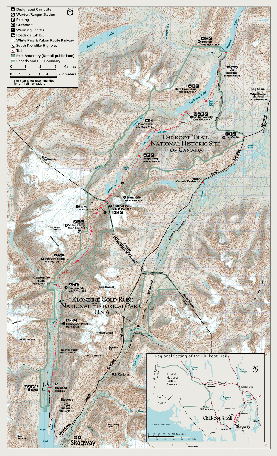
The Chilkoot Trail is 53 km (33 miles) from Dyea, AK to Bennett City, BC with an elevation gain of over 1000 meters (3500 feet). The average trip length is between three and five nights on the Trail.
Most hikers spend two nights on the American side of the trail though faster hikers will often opt to spend only one night. It is desirable, especially in the early season when avalanche hazard is a concern, to stay in Sheep Camp the night before crossing Chilkoot Pass. Spending two nights on the American side is recommended in the early season to facilitate an early departure from Sheep Camp. An early start (on the trail before 6 am) is essential to ensure safer travel through the avalanche zones early in the day when avalanche hazard is lower.
Crossing Chilkoot Pass
Climbing the the "Golden Stairs"
Crossing the pass can be a very demanding day. Over 750 meters (2500 feet) are gained in the 5.7 km (3.5 mile) section between Sheep Camp and the top of Chilkoot Pass. The portion of the hike from the Scales over Chilkoot Pass is a route not a trail. Fog and low visibility are common in this section, making the route hard to follow. The terrain up and over the pass can also be snow covered well into July and some years August, making the route all the more difficult to follow. Route finding skills are essential. It often takes 12 hours to travel from Sheep Camp up and over Chilkoot Pass to Happy Camp, a distance of 12.1 km (7.5 miles).
In the early season hikers are advised to travel early and take a rest/lunch break at the Pass before proceeding through the avalanche zone to the north. There is a day use shelter at the top of Chilkoot Pass making it a logical place for a rest/lunch stop. There is no camping at Chilkoot Pass.
Descending the talus slope on the Canadian side of the pass
Descending the talus slope on the Canadian side of the pass requires slow travel and can be very hard on the knees. Hiking poles are helpful. Beyond the pass the trail travels through avalanche terrain that can be active into mid-July. Snowfields between the Scales and Happy Camp also persist throughout the summer months. Many hikers find that it takes as long to hike from Chilkoot Pass to Happy Camp as the climb from Sheep Camp to the pass. Plan your day accordingly, and take the time needed to rest.
We strongly recommend spending the night at Happy Camp after your push over Chilkoot Pass. Be prepared to camp on snow until late June/early July. Most people spend either two or three nights on the Canadian side of the trail. Spending an extra night will give you more time to relax after the "push" over the pass. Happy Camp, Lindeman City and Bennett are generally the campgrounds selected by those spending three nights on the Canadian side. If you are considering spending two nights on the Canadian side, Lindeman City and Bare Loon Lake are both within striking distance of Bennett by train time.
There is no telephone or cell phone service along the entirety of the trail, including Bennett. All post-hike travel arrangements must be made prior to starting your hike.
Hiking season
During the summer hiking season (June to mid September) you may encounter Parks Canada and U.S. National Park Service (NPS) staff along the trail. While NPS has a Ranger station and Parks Canada has a staff cabin at Lindeman City, there is no guarantee that someone will be at these locations at a times you may require assistance. Regardless of the season, you are responsible for your own safety and may be expected to pay for rescue/medical costs. You should have international travel insurance that covers these types of expenses.
Early June
Winter-like conditions Chilkoot Pass in early June
Extensive snow travel is required and travel conditions may be very difficult but the days are wonderfully long. Winter travel equipment and winter travel experience is strongly recommended. Snow camping is likely. There will be few other hikers on the trail. Check with the Trail Center for seasonal conditions.
Avalanche hazard: During this time you will want to cross Chilkoot Pass early in the day to reduce your exposure in avalanche terrain.
Mid-June to early July
Early season backpacking Early Summer view of Chilkoot Pass
Expect significant amounts of snow at higher elevations. As the season progresses, the snowfields become "punchy" and develop snow/ice bridges over streams and between rocks which can collapse without warning. Travel conditions are highly variable and dependant on weather and time of day.
Avalanche hazard persists until mid-July. During this time you will want to cross Chilkoot Pass early in the day to reduce your exposure in avalanche terrain.
Mid-July to early August
Summer backpacking Chilkoot Pass in July
The trail/route is generally snow free though some snow patches persist. Travel conditions are highly variable and dependant on weather. Severe rain or snow storms are possible even in the middle of summer.
Peak visitor use occurs during this period. Campgrounds can be crowded. Reservations are strongly recommended.
Mid-August to mid-September
Fall backpacking View from Chilkoot Pass in early September
The trail/route is generally snow free though a few snow patches may still persist.
Fall weather is wetter; daylight hours are shorter and nights are colder (often below freezing). The colours are turning.
There are fewer hikers on the trail at this time of year.
Post season
Mid-September into October Hiking in late September
There is no regular patrol presence on the trail and the trail/route is not marked. Up-to-date information on trail conditions is no longer reliably available. Fall weather is wet; daylight hours are short and nights are cold (below freezing). As fall progresses fresh snow becomes increasingly likely. You will need to be self sufficient and accept a high level of responsibility for your own safety. Winter travel experience, route finding, avalanche hazard evaluation and self rescue skills are required.
There are no fees in the off-season, however you must contact the National Park Service in Skagway (907-983-9200) or Parks Canada in Whitehorse (1-800-661-0486) prior to your trip. Border crossing procedures apply.
You have the option to start your Chilkoot Trail hike at either Dyea, Alaska (near Skagway) or Bennett, British Columbia. Most hikers hike north from Dyea to Bennett in the footsteps of the stampeders. If you start in Dyea, plan to pick up your permit at the mandatory trail orientation at the Trail Center in Skagway. If you start at Bennett, call the Whitehorse Parks Canada office for more information (1-867-667-3910 or 1-800-661-0486).
Dyea trailhead (Alaska)
The Dyea trailhead is a distance of 16 km / 10 miles from Skagway. Access is by all-weather dirt road. Overnight parking is available in Dyea at the National Parks Service campground located 1 km / 0.5 miles from the trailhead.
Private shuttle companies provide transport from Skagway to Dyea. While these services are reliably available, operators vary from season to season and specific contact information is not available until the onset of the summer hiking season. Contact the Trail Centre for more information for these services.
Camping is allowed in designated campgrounds only. Individual campsites within the campgrounds are available on a first-come, first-serve basis. Open fires are prohibited. There are wood stoves available in some shelters below tree line, but wood supplies may be scarce and/or wet. Carry a backpacking stove and plenty of fuel.
When you make your reservation you must specify which campgrounds you will stay at for each night of your trip and how many tent sites you will need. While this requires careful pre-trip planning, it eliminates over-crowding in campgrounds and ensures that everyone will have a place to camp. Plan for a minimum of two hikers per tent site.
Plan your hiking itinerary with the least experienced member of your group in mind.
Finnegan's Point is a small campground with limited space. Located 2-3 hours from the trailhead it is a good choice for those who will be getting a late start. It is also a popular first night destination for large groups as it allows them the opportunity to camp with few other parties competing for facilities. As space is limited you must be booked into Finnegan's Point if you wish to stay here.
From Finnegan's Point it is 12.9 km / 8 miles to Sheep Camp.
Canyon City is generally the first night stop for those spending 2 nights on the U.S. side of the trail. Staying here means a short (8.4 kilometer / 5.3 mile) second day hike to Sheep Camp, giving you an easier day before the more arduous push over the Pass.
There is an interesting side trail just north of the campground that takes you to an historic steam boiler that powered a tramway from Canyon City over Chilkoot Pass during the gold rush.
Pleasant Camp is a good campsite to use as a staging area for a return trip to Chilkoot Pass for those who will be remaining on the U.S. side. The one way distance to Chilkoot Pass is 9.3 km / 5.8 miles.
For experienced hikers who are accustomed to hiking longer distances Pleasant Camp offers a quieter alternative to Sheep Camp the night before going over Chilkoot Pass. From Pleasant Camp it is 15.7 km / 9.8 miles to Happy Camp.
In the early season it is not recommended to stay at Pleasant Camp the night before going over Chilkoot Pass due to increased avalanche hazard.
Sheep Camp is the last campground before Chilkoot Pass, making it the ideal staging area for the hike over Chilkoot Pass. From Sheep Camp it is 12.1 kilometers / 7.5 miles to Happy Camp; and, 16.7 kilometers / 10.4 miles to Deep Lake.
Early season hikers, regardless of ability, are strongly encouraged to stay at Sheep Camp the night before going over Chilkoot Pass due to avalanche hazard. An early departure from Sheep Camp (on the trail before 6 am) is essential to ensure safer travel through the avalanche zones early in the day when avalanche hazard is lower.
Don't miss the Ranger Talk at 7 pm each evening.
Canadian campgrounds
Happy Camp:
kilometre 33 / mile 20.5
Happy Camp
Location & facilities
Happy Camp tent sites
Trail mileage: kilometer 33 / mile 20.5 Elevation: 899 meters / 2950 feet Setting: Alpine, next to creek UTM coordinates: 8V 490355 6622805
(NAD 83)
Tent sites: 23 sites, wooden platforms. Cook shelter: NO. A cooking and eating platform will be identified for you. Food storage: Bear lockers
Description
On the trail leaving Happy Camp
Happy Camp is the first campground after Chilkoot Pass, making it the most popular destination on “summit day”. Located in the high country, above treeline, the tent sites are exposed and the weather often severe. Spring hikers should be prepared to camp on snow.
From Happy Camp it is 8.8 kilometers / 5.5 miles to Lindeman City; and 13.7 kilometers / 8.5 miles to Bare Loon Lake.
Deep Lake:
kilometre 37 / mile 23
Deep Lake Campground
Location & facilities
Early season at Deep Lake
Trail mileage: kilometer 37 / mile 23 Elevation: 884 meters / 2900 feet Setting: Treeline, overlooking lake near creek mouth UTM coordinates: 8V 492132 6625233
(NAD 83)
Tent sites: 11 sites, wooden platforms and ground sites Cook shelter: NO: cooking area with picnic table Food storage: Bear lockers
Description
Deep Lake is an excellent lunch stop en route to Lindeman and Bare Loon
Smaller than Happy Camp, Deep Lake is a potential “summit day” destination for experienced hikers who are used to hiking longer distances and camping with fewer facilities. Though there is no cooking shelter here the weather is often better; and, located at treeline the tent sites are more sheltered.
From Deep Lake it is 9.7 kilometers / 6 miles to Bare Loon Lake; and, 16.1 kilometers / 10 miles to Bennett.
Lindeman City is located in a beautiful, historic setting on the shores of Lindeman Lake. Today’s tranquil ambience stands in stark contrast to the hustle and bustle of 1898 evident from the many artifacts left behind and scattered around Lindeman.
Lindeman is a camping place of choice for those spending 3 nights on the Canadian side of the trail. If spending only 1 or 2 nights on the Canadian side of the trail, Lindeman is within striking distance (11.3 kilometers / 7 miles) of Bennett by train time.
The main base of operations for Parks Canada staff is located at Lower Lindeman, however staff are not there daily.
Bare Loon Lake:
kilometre 46.7 / mile 29
Bare Loon Lake Campground
Location & facilities
Bare Loon tent sites
Trail mileage: kilometer 46.7 / mile 29 Elevation: 747 meters / 2450 feet Setting: Open forest, on rocky outcrop overlooking lake. UTM coordinates: 8V 497876 6628630
(NAD 83)
Within easy striking distance of Bennett by train time, Bare Loon is a popular – though sometimes crowded – final night destination. From Bare Loon it is 6.4 kilometers / 4 miles to Bennett.
Bennett:
kilometre 53.1 / mile 33
Bennett Campground
Location & facilities
Bennett shelter
Trail mileage: kilometer 53.1 / mile 33 Elevation: 670 meters / 2200 feet Setting: Forest edge, at river mouth near lakeshore UTM coordinates: 8V 500079 6634157
(NAD 83)
Tent sites: 18 sites, on the ground Cook shelter: Cabin Food storage: Bear lockers.
Description
St. Andrew's Presbyterian Church, Bennett
Once a bustling tent city, Bennet is located on the shore of Lake Bennett at the northern terminus of the Chilkoot Trail. Of historic interest is St. Andrew's Presbyterian Church – the last remaining gold rush era building along the Chilkoot Trail. The scenic campground at Bennett is located in what was once the heart of the historic townsite.
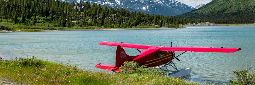
Bennett is generally the final night destination for those spending 5 nights on the trail. Accessible by train, or floatplane, it is also a potential overnight destination for campers who do not wish to hike the entire trail, or those wanting to rendezvous with a party who has hiked over the trail.
A camping permit is required for overnight camping at Bennett. Fees apply (for those hiking or running the Chilkoot Trail the Bennett camping fee is included in your permit).
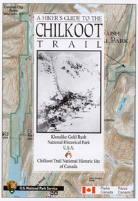
Map: Chilkoot Trail map
Map available for purchase
A Hikers Guide to the Chilkoot Trail
Annotated Chilkoot Trail Map: $9.50 + shipping
Available from Parks Canada - Yukon
Telephone:
1-800-661-0486 (North America toll free)
867-667-3910 (local or overseas)
Permits and regulations
During the summer hiking season, every person overnighting on the Chilkoot Trail requires a permit. Those without required permits are subject to fines. Reservations are strongly recommended.
A safe and enjoyable trip on the Chilkoot requires careful preparations. You must be well equipped, self sufficient and in good physical condition. Hiking with a partner or small group is preferable.
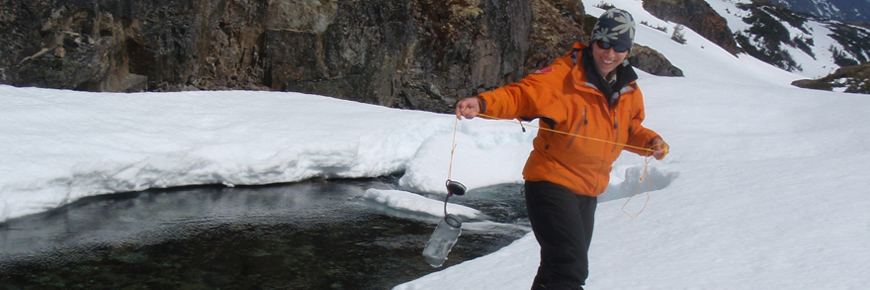
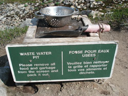
Waste water is disposed of differently on the U.S. and Canadian sides of the trail:
U.S. side:
Toss waste water into the fastest flowing part of the river
Canadian side:
Use wastewater disposal pits, located in all campgrounds and at Chilkoot Pass. Be sure to clean food waste off the screen and pack it out with your garbage.
Never wash clothes, dishes, or yourself directly in a water source.
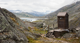
Outhouse at Chilkoot Pass
Human waste
Outhouses are located in all campgrounds and at Chilkoot Pass.
Toilet paper is not supplied on the Canadian side of the trail, and supplies on the U.S. side are sometimes limited.
Bring your own!
Pack in - pack out
Nothing should be discarded in the park. You must pack out everything that you pack in.
Bring a garbage bag/container for your garbage and food waste: ziplock-type bags work well
Store all garbage/food waste in the storage lockers with your other attractants
Take all garbage/food waste with you when you leave
Keep your meals simple and light – this will cut down on the weight you carry in and the garbage that you will have to carry out.
Be self-reliant
Chilkoot Trail National Historic Site is a remote wilderness park. Natural hazards are present in the area.
Let someone know your plans. Leave your itinerary, route map and the names of the people in your hiking party with a friend or family member at home, ideally your emergency contact.
Carry Parks Canada’s 24-hour emergency dispatch phone number with you, and leave it with your emergency contact at home. 1-780-852-3100
Carry emergency gear. We recommend extra food, fuel and lighters or matches, a spare set of clothes, and duplicates of your medication etc.
Bring a communication device (InReach, satellite phone, other non-cellular device). There is no cellular service anywhere within the Chilkoot Trail National Historic Site including Bennett.