

King's Throne
Kluane National Park and Reserve
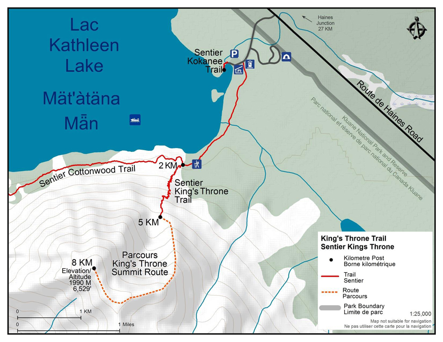
Distance: 10 km (6 mi) return to cirque; 16 km (10 mi) return to summit
Time: 4 - 6 hours to cirque; 8 - 10 hours to summit
Elevation gain: 548 M (1,800') to cirque; 1,442M (4,729') to summit
Maximum elevation: 1,280 M (4 200') at cirque; 1,990 M (6,529') at summit
Trailhead: 27 km (17 mi) south of Haines Junction on the Haines Road, on the Kathleen Lake access road.
Topo map: Kathleen Lakes 115 A/11
In summary
This is a steep trail up to a spectacular cirque—the “seat” of the King’s Throne. It is possible to follow an unmarked, unmaintained route to the peak of the mountain. Alpine flowers and great views are some of the highlights of this trail. Keep in mind this trail is steep and the rocks can be slippery when descending, even in dry weather.
Download the King's Throne trail and summit route descriptions (PDF, 409 Kb)
The details
Kings Throne trail
The trail begins at the Cottonwood trailhead (located between the campground road and the lake shore on the Kathleen Lake access road). For approximately the first 2 km, the trail follows an old mining road along the south side of Kathleen Lake. Watch for a trail marker indicating where the King's Throne trail and Cottonwood trail branch off to the left. Here, at the base of the mountain, the trail begins to climb through a forested area. Another trail marker will indicate where the Cottonwood trail branches to the right. Stay left to continue up the King’s Throne trail. Once the trail emerges from the trees, it zigzags back and forth up the mountain. Please hike on the switchbacks and avoid shortcut trails to prevent erosion. This will take you to the bench of the throne. The maintained trail ends here.Summit route
A route is not a trail
Routes are not marked with signs or maintained in any manner. The route described here is only a suggestion that may help guide you on your trip. Self-reliance and wilderness travel experience are essential, including excellent route finding skills, map and compass skills. It is the responsibility of individual hikers who choose to follow such routes to adequately prepare and be prepared to rely on themselves.Distance: 6 km (3.8 mi) return trip
Time: 2-4 hours
Elevation gain: 710 m (2,329’)
Maximum elevation: 1,990 m (6,529')
What you need to know
The steep scree and rock slopes encountered on this trail and route can be unstable, slippery and can present some difficult hiking. Weather is another factor to consider on this route. Strong wind gusts can be a hazard on the exposed ridges. Clouds can descend rapidly and make finding the trail or route difficult. The rocks can be slippery when descending, even when dry. If it starts to rain, the descent can become even more slippery. Please use caution.
Sturdy footwear and hiking poles are highly recommended for the trail and route.
Bear sightings are common in the area. Review recommendations for travel within the You Are In Bear Country brochure. All bear sightings should be reported to the staff at the Kluane National Park and Reserve Visitor Centre in Haines Junction or the Thechàl Dhâl Visitor Centre.
Parks Canada 24 hour emergency dispatch
1-780-852-3100
Cellular telephones do not work in most of the park. Satellite phones or satellite messaging devices are strongly recommended.
Related links
- Date modified :