
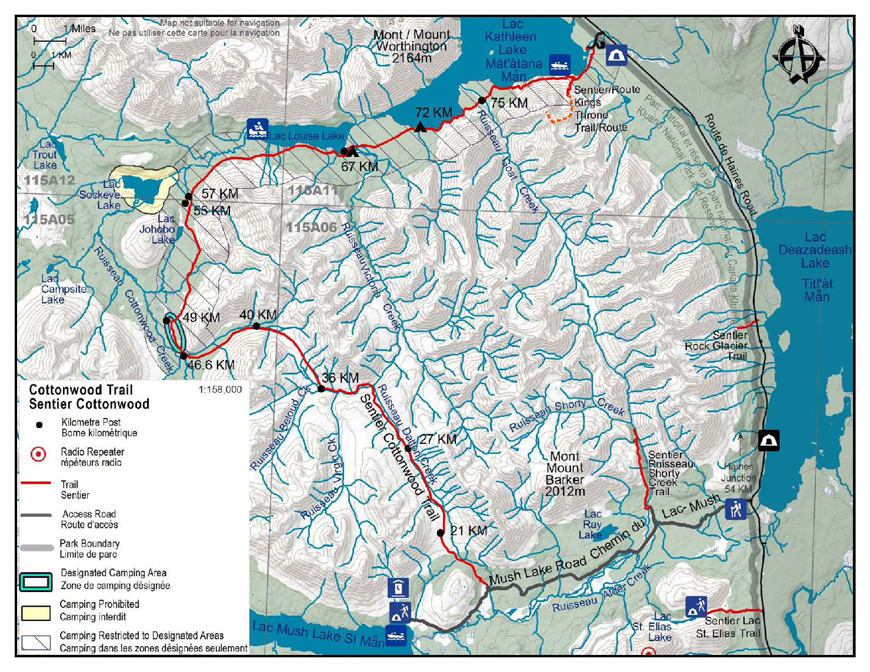
Cottonwood Trail
Kluane National Park and Reserve
Distance: 85 km (53 mi) loop
Time: 4-6 days
Elevation gain: 520 m (1,700’)
Maximum elevation: 1,310 m (4,300’)
Trailheads:
- Kathleen Lake day-use area, 27 km (17 mi) south of Haines Junction on the Haines Highway
- Mush Lake Road, 54 km (33.5 mi) south of Haines Junction on the Haines Highway
Topo maps:
- Kathleen Lakes 115 A/11
- Mush Lake 115 A/6
- Auriol 115 A/12
- Cottonwood Lakes 115 A/5
In summary
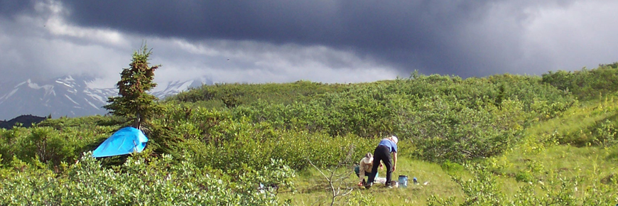
The Cottonwood Trail is an 85 km partial loop that can be started at either Kathleen Lake or the Mush Lake Road. The trail varies from 4-wheel drive road to single track; it passes through stands of spruce and poplar; crosses two mountain passes, and follows through open meadows. For the adrenalin thirsty, the highlight of this trail may be the adventurous creek crossings. A variety of wildlife including Dall sheep, mountain goat, grizzly and black bear, ptarmigan, owl, moose and others inhabit the area. The trail is marked with km posts in most areas, and is relatively easy to follow. There are few bridges on this trail so hikers must be prepared to wade across creeks in order to cross. During high water, it is recommended that people leave from the Kathleen Lake side of the loop, as Victoria Creek can be challenging and sometimes impassable. The Cottonwood Trail can commonly be hiked from June to early September.
The details
Kathleen Lake to Mush Lake Road
Download the Cottonwood Trail (Kathleen Lake to Mush Lake Road) description (PDF, 843 Kb)
Km 82.7-81.0: The trailhead for the Cottonwood is shared with the King’s Throne trailhead on the Kathleen Lake access road. This marks the beginning of a 36 Km section of the Cottonwood Trail with designated campsites; the first one is at an unnamed creek at approximately Km 71.3: you must hike at least this far on the first day. The trail parallels Kathleen Lake but does not follow the shore (this is the old trail, and is no longer maintained). The first part of the trail follows an old mining road but then switches to a single track trail. During mid to late summer, Sheperdia canadensis (Soapberry or Buffalo berry) is abundant from Kathleen Lake through to the Cottonwood Meadows at km 49 and is an important food source for bears: be vigilant in making noise and be very bear aware.
Km 81.0-77.9: The split between the King’s Throne trail and the Cottonwood is marked by a post. King’s Throne veers left and heads up the face of the mountain: do not follow this trail. Instead, veer to the right and continue on the Cottonwood trail. The trail skirts above Kathleen Lake, crosses a series of avalanche paths and then comes to a rock glacier.
Km 77.9-74.2: The trail crosses the rock glacier and is marked by a series of rock cairns. Continue along the trail as it heads inland, arriving at Goat Creek. Goat Creek is usually narrow and swift so you will need to scout out a suitable spot to cross. Goat Creek campsite has been permanently closed due to frequent bear activity in the area.
Km 74.2-71.3: The trail continues across the peninsula and then follows along the lakeshore. A rockslide occurred at km 72. It is highly recommended to carefully skirt around the slide. At km 71.3, the trail crosses an unnamed creek. This is the first of three designated campsites. Do not camp in the treed area where the trail meets the creek; instead, choose a site with good visibility near the lakeshore. The next designated campsite is approximately 4 km further at Victoria Creek.
Km 71.3-67.1: The trail continues on the other side of the unnamed creek to lower Victoria Creek at km 67.1. Km 67 marks the location of the second designated campsite. The next designated campsite is at Cottonwood Meadows between km 49 and km 47, 18 to 20 km from lower Victoria Creek. There is no camping permitted between here and Cottonwood Meadows. This is the first of two times that you will cross Victoria Creek. Exercise caution as the creek has a large volume of water and flows swiftly. Search up and downstream for a spot where the creek is widest, shallowest and splits into multiple braids. It might be wise to camp overnight and cross in the morning when water levels may be lower. There are sign posts on either side of the creek that lead back to the trail.
Km 67.1-57.3: The trail leaves the lower Victoria Creek alluvial fan and climbs above and alongside Louise Lake for 10 km, arriving at an unnamed creek that flows into Sockeye Lake.
Km 57.3-55.7: Look for the remains of the abandoned Johobo mine. The mine operated until the early 60’s. A purplish-coloured copper ore, known as bornite, is found in small veins in volcanic rock and was excavated at this mine. The entrance to the former mine shaft is visible on the mountain that you pass on your left. This section has some cleared areas that provide great opportunities to see wildlife tracks.
Km 55.7-52.4: As you leave the Johobo mine site, the trail works with way through an old spruce forest and arrives at another unnamed creek that you will need to cross. The area has been subjected to a recent washout, but the trail picks up on the other side.
Km 52.4-49.0: The trail continues on the mining road but eventually bends right and becomes a single track that leads you down to Cottonwood meadows. As you reach the meadow, the trail becomes spongy and wet in the first section where a small creek runs through. This is the last source of running water until you reach Cottonwood Creek at km 46.6. It is best to obtain water here as the meadows are dry. The km 49 post stands out in the meadow.
Km 49.0-46.6: Km 49 to km 47 marks the last designated camping area. The trail winds its way through the meadow. Just before the trail leaves the meadow and enters a lush spruce and willow forest, you may notice a long “bear stomp” that approaches and leaves a spruce tree. A bear stomp is an area of indented footprints made by a bear (or several bears) following in the same tracks over time. Stomps often lead to scratching trees where the bears rub and claw the tree. The trail exits the forest at km 46.6 where it meets and crosses Cottonwood Creek.
Km 46.6-41.8: When Cottonwood Creek is low, you may be able to walk up the creek bed. Otherwise, the trail now turns east and wanders through meadow thickets and balsam poplar groves. Watch for marker posts where the trail crosses the creek as you head up Cottonwood Valley. Higher water can cause the creek to overflow and make the trail difficult to find in sections. Keep working your way up the valley. The trail crosses a smaller creek that enters Cottonwood Creek: this is the halfway point of the trail.
Km 41.8-39.3: The trail continues up Cottonwood Valley towards Cottonwood Pass, winding through more groves of balsam poplar and wildflower meadows until you emerge above the tree line.
Km 39.3-37.5: The trail loses 150 metres (500 feet) in elevation along this section of the trail as you descend from the first of two mountain passes you will cross during the hike. Posts or stone cairns mark the trail. If you have extra time, this is a nice area to explore further.
Km 35.7-33.0: The trail meets mining road again and turns left to head downstream along upper Victoria Creek. Posts on either side of Victoria Creek mark the best crossing areas. This is the second and last time you will cross Victoria Creek: it may be as swift as or deeper than the lower section as it does not braid.
Km 33.0-26.7: The trail quickly crosses Shrikes Creek twice and then enters a steep switchback and then meanders gently uphill until you reach Dalton Pass.
Km 26.7-21.5: This alpine area is known as Dalton Pass. The trail traces the west side of Dalton Creek, crossing many smaller creeks along the way. In spring, this area is very wet and not suitable for camping. Grizzly bear, moose and ptarmigan are common to the area; however, other wildlife sightings may include foxes, coyotes, wolves, wolverines, sheep, goats, marmots, pikas, arctic ground squirrels, golden eagles and many other bird species. The meadow at km 21.5 is the site of the old Dalton Camp and is not recommended for camping as there is an abundance of bear signs in the area and is an obvious travel route for wildlife. If you do camp in the area, it is best to head west, following the meadow, and find a camp site that you are comfortable with: there seems to be less bear signage in this direction and appears to be less of a travel route.
Km 21.5-16.5: The trail descends steadily for the next 5 km travelling through spruce forest and following alongside Dalton Creek. The trail meets Mush Lake road where you will turn left (turning right will take you on a steady 5 km climb to Mush Lake).
Km 16.5-12.0: Dalton Creek can be crossed via a footbridge on the north side of the road. This area, a former primitive campsite, and the area next to the creek at km 12.0 are not recommended for camping due to bear activity (look for claw marks in the trees). A small footbridge hidden on the north side of the road conveniently bridges the unnamed creek.
Km 12.0-7.5: The trail is high and dry, crossing numerous small hills and low sections along the north side of the valley until you reach Alder Creek.
Km 7.5-0: You will need to cross the many channels of Alder Creek, after which you will continue on the Mush Lake Road. Do not take the branches that lead left; they take you to the trailhead of Shorty Creek. The rest of the road is flat and easy to follow and ends at the Haines Highway, 54 km (33.5 mi) south of Haines Junction.
Mush Lake Road to Kathleen Lake
Download the Cottonwood Trail (Mush Lake Road to Kathleen Lake) description (PDF, 862 Kb)
The first section (16 km) of the Cottonwood Trail follows the Mush Lake Road, a 22 km one lane, four-wheel drive road joining the Haines highway to Mush Lake.
Km 0 - 5.5: The trail is flat and easy to follow.
Km 5.5 - 7.5: At the first trail junction, take the left trail (headed west) as the right trail (veering north) leads to Shorty Creek. From this junction for about a kilometer, you will cross the many channels of Alder Creek.
Km 7.5 - 12.0: After Alder Creek the trail stays high and dry, crossing numerous small hills and low sections along the north side of the valley.
Km 12.0 - 16.5: A small footbridge hidden on the north side of the road conveniently bridges the unnamed creek. There are bear claw marks on the trees around here, this area and the old primitive campsite at Dalton Creek are not recommended for camping due to bear activity. Dalton Creek can be crossed via the footbridge on the north side of the road.
Km 16.5 - 21.5: The road branches, the left trail continues west climbing steadily for 5 km to Mush Lake. Take the right branch turning uphill and to the north. The Cottonwood Trail climbs steadily for the next 5 km, travelling through a spruce forest alongside Dalton Creek. The trail emerges at a meadow; this is the old Dalton Camp that is not recommended for camping. There is an abundance of bear sign in the area; it is obviously a popular travel route for wildlife. If it is near the end of the day and you are in search of a place to camp, your best alternative to continuing on, is to head west following the meadows and find a camp site that you are comfortable with, there seems to be less bear signage in this direction, as it appears to be less of a travel route. If you are continuing on the trail, head right (north) at the primitive Dalton Camp, the trail climbs to a beautiful alpine pass.
Km 21.5 - 26.7: The alpine pass is known as Dalton Pass. The trail traces the west side of Dalton Creek, crossing many smaller creeks along the way. In spring this area is very wet and not suitable for camping. Grizzly bear, moose and ptarmigan are common to the area, however other wildlife sightings may include fox, coyote, wolves, wolverines, sheep, goats, marmots, pikas, ground squirrels, golden eagles, and smaller birds.
Km 26.7 - 33.0: From the pass the trail continues downhill, roughly following Shrikes Creek. After a steep switchback, the trail crosses upper Victoria Creek. Posts on either side of Victoria Creek mark the best crossing areas (Victoria Creek is crossed a second time, where it empties into Louise Lake at km 67).
Km 33.0 - 35.7: The trail heads west (upstream) along Victoria Creek, and is easy to follow up to km 35.7. Although the road continues, follow the trail that cuts up to the right. This is the only way out of the valley!
Km 37.5 - 39.3: You will gain 150 M (500') in elevation along this section of the trail as you cross the second mountain pass of your hike. Posts or stone markers mark the trail. If you have any extra time, this is a nice area to explore further.
Km 39.3 - 41.8: You are now in the Cottonwood Valley. The trail winds downhill into groves of balsam poplar trees and wildflower meadows.
Km 41.8 - 46.6: This is the halfway point of the trail. Cross the smaller creek that joins Cottonwood Creek, however it is best to remain on the left side of Cottonwood Creek, particularly during high water. Watch for a marker downstream that indicates where the trail crosses the creek and follows a series of meadow thickets. It will continue through these meadows until it emerges once again at Cottonwood Creek (km 46.6). When the creek is low, you may be able to walk down the creek bed. It is recommended to obtain water before reaching the designated campsite, as the meadows are dry and water may not be available. Kilometre 47 is the beginning of a 36 km stretch of the trail where camping in designated campsites is mandatory.
Km 46.6 - 49.0: The trail now turns north and wanders through a spruce and willow forest for about l km before opening up in a very large meadow. The first designated camping area is located in this two-kilometre stretch of meadow (km 47 - km 49). The next camping area is also a designated site and is 18-20 km away at Lower Victoria Creek. There is no camping allowed between these two areas. You may notice a long "bear stomp" that approaches and leaves one of the last spruce trees leading into the meadow. A bear stomp is an area of indented footprints made by a bear (or several bears) following in the same tracks over time. Stomps often lead to scratching trees, where the bears rub and claw.
Km 49.0 - 52.4: The 49.0 km signpost stands out in the meadow. There is no camping from this point (km 49) until Victoria Creek at km 67. The trail leaves the meadow and turns right along the side hill to avoid wet areas. The section leaving the meadow may be spongy and wet however conditions dry up as the trail climbs to the abandoned mining road leading to Kathleen Lake. During mid to late summer Sheperdia canadensis (Soapberry or Buffalo berry) is abundant from this section of trail through to Kathleen Lake. Be vigilant in making noise and very bear aware.
Km 52.4 - 55.7: The trail crosses a creek and the road continues down through an old spruce forest until you arrive at the Johobo mine site.
Km 55.7 - 57.3: Look for the remains of the abandoned Johobo mine. The mine operated until the early 60's. Bornite, a purplish coloured copper ore found in small veins in volcanic rocks, was excavated in the mine. The small mountain on the right contains the entrance to the mineshaft. The cleared area offers great opportunity to see wildlife tracks.
Km 57.3 - 67.1: The next l0 km follows a side hill that overlooks Louise Lake, eventually arriving at the lakeshore and lower Victoria Creek alluvial fan.
Km 67.1 - 71.3: Kilometre 67 marks the location of the second designated campsite. For the second time on the trip you'll cross Victoria Creek, however exercise caution as the volume is greater and the flow swifter. It may be wise to spend the night and cross early in the morning when water levels are lower. Search up and downstream for a spot where the stream is wide and shallow. There are signposts on either side of the creek that lead back to the trail.
Km 71.3 -74.2: There is one additional designated campsite approximately 4 km east of Victoria Creek. This site is located along the shore of Kathleen Lake where the trail crosses an unnamed creek at approximately km 71.3. Pick the site with the best visibility next to the lakeshore rather than in the treed area near the trail. This is the last designated camping site before the Kathleen Lake trailhead. Plan to hike the remainder of the trail in one day (about 12 km). The trail continues along the lakeshore and meets a peninsula at km 74.2. A rockslide occurred at km 72. It is highly recommended to carefully skirt around the slide.
Km 74.2-77.9: Goat Creek campsite has been permanently closed due to frequent bear activity in the area. The trail crosses Goat Creek, a creek that is usually narrow and swift so you may need to scope a good crossing spot. The trail climbs onto and over a rock glacier just past Goat Creek, this section is single track with several switchbacks, rock Cairns mark the way.
Km 77.9 - 81.0: The trail skirts the slope above Kathleen Lake, crossing a few avalanche paths before descending to the King’s Throne trail junction (marked with a post). The trail veering right climbs the Kings Throne, do not take this trail but continue straight along Kathleen Lake.
Km 8l.0 - 82.7: The trail winds along Kathleen Lake eventually opening up on an old mining road and ends at the Kathleen Lake Day Use Area, 27 km (17 mi) south of Haines Junction.
What you need to know
For all overnight trips in the park Approved Bear Resistant Food Canisters are mandatory and a Wilderness Permit is required, both can be obtained from the Kluane National Park and Reserve Visitor Centre in Haines Junction. For more information: Overnight Registration.
In an attempt to reduce the potential for bear/human conflicts while camping along the Cottonwood Trail, camping in the designated camping areas is mandatory from Km 82.7 to Km 47 (between Kathleen Lake and Cottonwood Creek), however random camping is permitted for other areas of the trail.
Three sites have been identified as having a lower risk for encounter than other sites and areas assessed. These are 1) along the shore of Kathleen at an unnamed creek at approximately km 71.3; 2) the Lower Victoria Creek fan (km 67) and 3) Cottonwood meadows (km 47-49).
Travellers are required to hike through the trail segments between these areas before camping. This will require that people plan their trip carefully. The approximate distances between sites are:
- Kathleen Lake to Unnamed creek (km 71.3) 12 km
- Unnamed creek to Lower Victoria (km 67) 4.3 km
- Lower Victoria to Cottonwood Meadows (km 47-49) 18 km
Bear sightings are common in this area. Trail closures due to bear activity can occur during the summer months. Staff at the Kluane National Park and Reserve Visitor Centre in Haines Junction will have the latest information. Review recommendations for travel in the You Are in Bear Country brochure. Please report all bear sightings to the staff at the Visitor Centre.
Parks Canada 24 hour emergency dispatch
1-780-852-3100
Cellular telephones do not work in most of the park. Satellite phones or satellite messaging devices are strongly recommended.
Related links
- Date modified :