

Alsek Valley Trail
Kluane National Park and Reserve
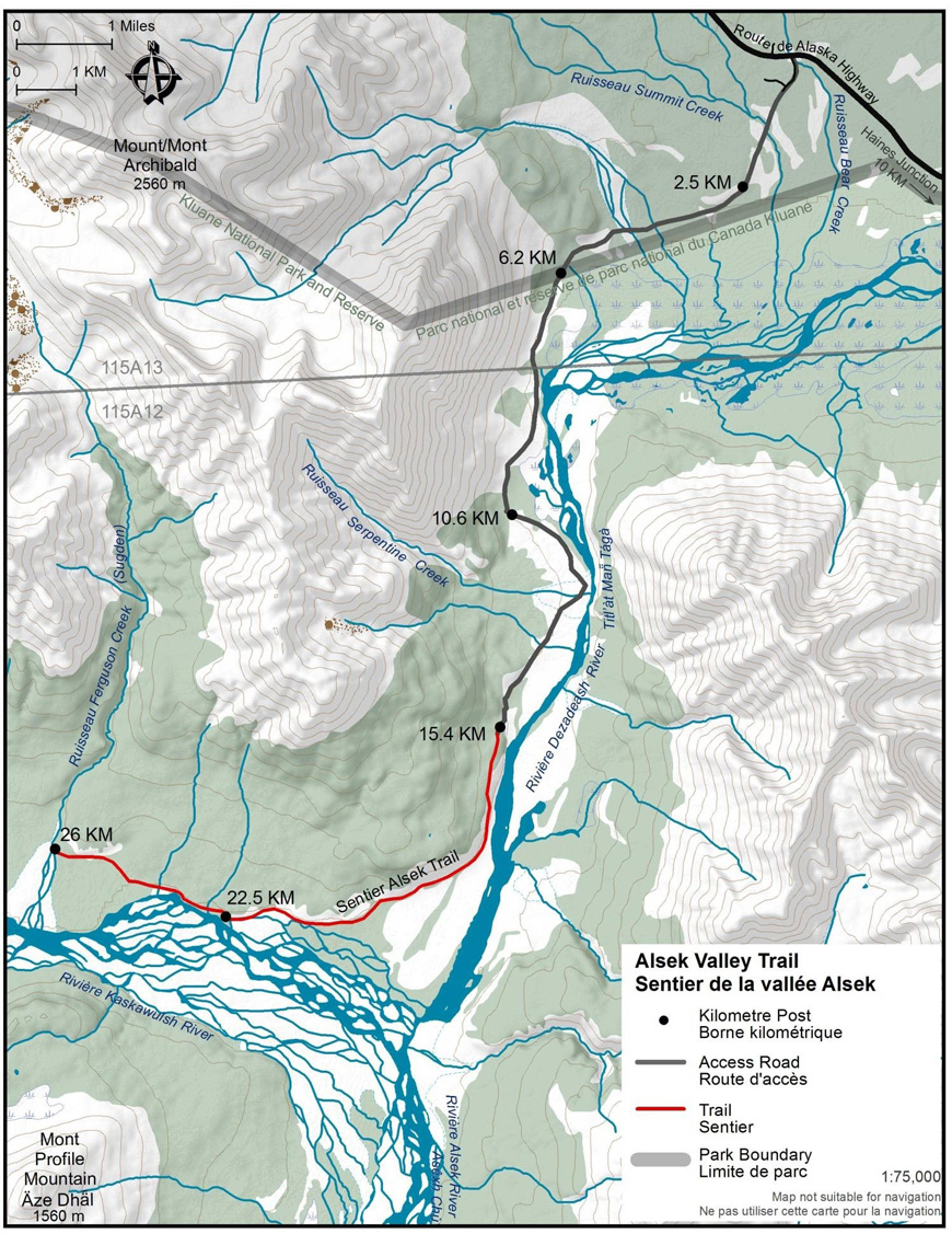
Distance: 52 km (32 mi) return trip
Time: 1-3 days
Elevation gain: 92 m (300')
Maximum elevation: 610 m (2,000')
Trailhead: from Haines Junction drive 10.6 km (6.6 mi) north on the Alaska Highway, turn left onto Nygren Subdivision Road, just opposite Bear Creek Lodge, and follow the road until the end.
Topo maps: Kloo Lake 115 A/13 & Auriol 115 A/12
In summary
This trail follows an old mining road into Sugden (Ferguson) Creek. The openness of the Alsek valley may provide opportunities to view wildlife from a distance. This trail makes an excellent biking trail and is a good bad weather trail due to the rocky surface of the trail and its low position in the valley. The first 15 km are open to 4-wheel drive access, when trail conditions are good.
Download the Alsek Valley Trail description (PDF, 700Kb)The details
The trail begins at the south end of the Nygren Subdivision road. It is relatively flat and easy to follow. It passes through open grassland, across alluvial fans, gravel washes, and through stands of spruce and poplar. Some of the creek crossings, can be high during spring run-off, heavy rainfall, or hot weather.
The park boundary is located 6.1 km down the road. The rock outcrop to the left makes for a good rest stop and wildlife viewing area. High beach ridges left behind by a succession of glacial lakes are also apparent from here. Further down the Alsek valley, the Lowell glacier has surged across the valley five different times during the past 3,000 years, damming the Alsek River and creating glacial lakes, the last one having drained only just over a century ago. Continuing along the road past the rock outcrop, you will eventually come to the large washout area of Serpentine Creek. Here, a creek crossing will be necessary to go along further.
Approximately an hour past Serpentine Creek is a wooded area where you will find a park gate at kilometer 15.4. Vehicles are not permitted beyond this point. The 22.5 kilometer post marks the junction of the Alsek, Dezadeash and Kaskawulsh Rivers. It will take about 2 hours from here to reach Sugden Creek (this creek may be called Ferguson on older maps). This is the end of the trail and is marked by the 26 km post. Sugden may be difficult to cross even when the water is low. There are some old mining cabins on the other side. Please leave artifacts undisturbed.
What you need to know
For all overnight trips in the park Approved Bear Resistant Food Canisters are mandatory and a Wilderness Permit is required, both can be obtained from the Kluane National Park and Reserve Visitor Centre in Haines Junction. For more information: Overnight registration.
This trail is also open to mountain biking. Both hikers and mountain bikers should be alert for bears and use caution when travelling up wind. Bear sightings are common in this area. Review recommendations for travel in the You Are In Bear Country brochure. Please report all bear sightings to the staff at the Visitor Centre.
Parks Canada 24 hour emergency dispatch
1-780-852-3100
Cellular telephones do not work in most of the park. Satellite phones or satellite messaging devices are strongly recommended.
Related links
- Date modified :