
Mount Rundle Scrambler’s Guide
Banff National Park
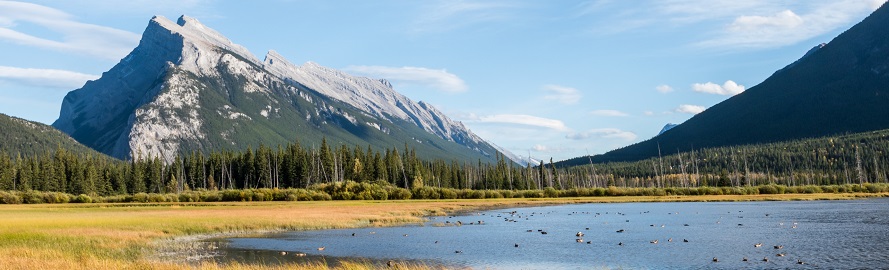
Mount Rundle, the prominent wedge-shaped peak immediately south of the town of Banff, is one of the most popular climbs in the Canadian Rockies. Rundle’s close proximity to the townsite and the relatively easy route it offers to the top often make this the first “real” climb for many visitors.
While Mount Rundle is considered an easy scramble, all mountains pose hazards. See the detailed route information and important safety tips.
Important! Mount Rundle is a summer climb.
Route conditions are best when there is no snow. The mountain’s shape and direction allow the west face to melt off earlier in the summer than many other local peaks. It is easy to check for snow—the entire route is visible from the road up to Sulphur Mountain and the Upper Hot Springs in Banff.Trailhead
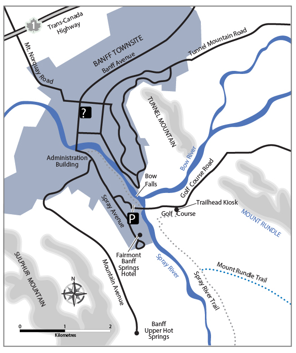
The trailhead for Mount Rundle is located near the Spray River bridge on the road to the Bow Falls viewpoint and the Banff Springs Golf Course. Park at the Bow Falls Day-use Area. Also accessible by an easy 20-minute walk from downtown Banff.
Walk across the bridge. Follow the Golf Course Road 350 m to the Spray River East trailhead kiosk on the right. Go past the kiosk and head 100 m west on the dirt trail. Take the east-most trail that branches left up the hill at the Spray River Trail sign. (Note: This is not the trail along the shore of the Spray River.) Follow the Spray River East trail for 600 m to the Mount Rundle Trail junction on the left.
The route description starts at this point.
Route Description
Summit: 2 949 m (9 675 ft.)
Elevation gain of climb: 1 577 m (5 175 ft.)
Distance: approx. 11 km round trip
Average round-trip time: 7-8 hours
This route description begins at the junction of the Mount Rundle Trail and Spray River Trail (see trailhead information). The following description matches the numbers on the route photo.
1. Lower Trail
Follow the excellent constructed trail that climbs steadily across the lower forested slopes of Mount Rundle. As the mountainside steepens, the trail begins to contour horizontally to the right. After almost an hour of hiking, reach the start of a dozen switchbacks that lead straight up the slope.
2. First Cliff Bands
On the route photo, notice the series of switchbacks actually leads up through a band of rocky cliffs that extend across the mountainside at the same elevation. This obscure cliff band is a significant hazard associated with the climb. Stay on route!
At the top of the switchbacks, the trail resumes a horizontal traverse to the right and soon heads down across the first of two large forested ravines. Shortly after the second ravine, the trail comes to an abrupt end at the edge of a large, rocky gully, known as the Central Gully.
3. Central Gully
The Central Gully marks the end of the hiking trail and the start of the “scrambling” section of the trip. The route to the summit crosses this gully and ascends to the top by way of the forested ridge beyond.
Two key safety pointers here:
- Do not climb up the Central Gully! Despite appearances, it is not a safe route to the summit. The gully is easy at the start but gradually steepens, forming dangerously smooth slabs where several people have been killed!
- On the descent, it is critical to return to this point and stay on the hiking trail for the rest of the way down. From across the gully, the end of the hiking trail is surprisingly difficult to see. Several fatal accidents have occurred when descending climbers missed the trail and fell while on a shortcut through the first cliff band that lies 100 m downhill from here. Yellow marker signs help define the route beyond the gully as a guide back to this crucial route home.
From the end of the hiking trail, descend a few metres and cross the gully (which may contain some old avalanche snow) to the bottom edge of an open rocky outcrop on the opposite slope. Scramble around the bottom of the outcrop to its right-hand side. From here, [look back] and spot the marker at the end of the hiking trail.
4. Forested Ridge
Scramble up the steep track in the trees just right of the rocky outcrops. Stick to the most obvious path that climbs directly up the slope. There is no “built” trail—only a few cut trees, and the path is slippery in places. About 100 m up the slope, the path traverses horizontally to the right and away from the steeper slopes overlooking the Central Gully.
From here on, the route climbs almost straight up through the forest. The path is well worn but continuously steep and smooth. Near the treeline the path has eroded badly to expose the smooth bedrock underneath. This entire section can become extremely slippery when wet.
5. The Dragon’s Back
The slope that the route follows is actually a ridge bounded by the Central Gully on the left side and another similar large gully on the right. This ridge leads most of the way to the top. Above treeline the ridge gradually narrows to form the “Dragon’s Back”, a sloping spine of rock between the two gullies. Its surface is the smooth slope of the limestone bedrock. For much of the way, it is covered by loose gravel, and there are steep cliffs on each side. Careful footing! [Look back] for landmarks.
6. The Summit
The ascent beyond the Dragon’s Back is a long and straightforward slog up the loose scree to the summit ridge. The ridge crest is a sharp edge with the vertical east face of Mount Rundle below. Traverse to the right along the ridge for about 100 m (mostly along the right side of the crest) to the summit high point marked by a cairn. There is a modest flat spot here to rest and enjoy the view.
- Cornices – Stay well back from the edge if there is any snow along the ridgeline. “Cornice” snow usually hangs out over the edge of the mountain and forms a deathtrap for the unwary!
- Traversing to any other peaks along the ridge is not recommended. Peaks are farther away than may appear and require technical climbing skills and equipment.
The Descent
Descend by the same route you climbed following the marked route. Retrace your steps. No shortcuts! Do not attempt an alternate descent down either of the gullies below. These may appear feasible options when viewed from the top, but dangerous terrain lies out of sight downhill. People have been trapped or killed in both gullies.
The Dragon’s Back ridge leads down to the trees. The yellow markers guide the way back to the Central Gully. If the trail has been missed and party members have descended too far, the only choice is to climb back up to the trail. Do not attempt to descend any cliffs!
Note: Damage to the switchback area is caused by people taking shortcuts on the way down. Please, stay on the path.

Related links
- Date modified :