
Architecture and urban plan for the glory of the monarchy
Saint-Louis Forts and Châteaux National Historic Site
Québec, fortified city
In the 17th century, in both French and English, a “city” was a walled or fortified geographic space. This was particularly true of the French, who had military engineers plan and develop the growth of new cities. In Quebec City, the relationship between defence and urban development was evident from 1636. The link was even closer later on, as much in general planning as in the network of streets, squares and blocks.
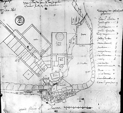 1660 plan showing the convergence of Old Quebec streets towards the Place d'Armes
© Library and Archives Canada, C-15801
Once the question of dividing concession lands was resolved, governor Montmagny focused on designing the limits of his city and coordinating them with the fortress he intended to “build regularly” out from the Saint-Louis fort and château. Adapted to the topography of the upper city's plateau, the network of streets spanned out from the fort and Place d'Armes. Military urban planning still shows in the topography and landscape of the upper city.
Glory and architecture
However, the monumental architecture involved in the Saint-Louis fort and château sometimes revealed unwritten goals... For example, what pushed Frontenac to build a second château? Personal vanity, no doubt, but also the desire to flatter Louis XIV as well.
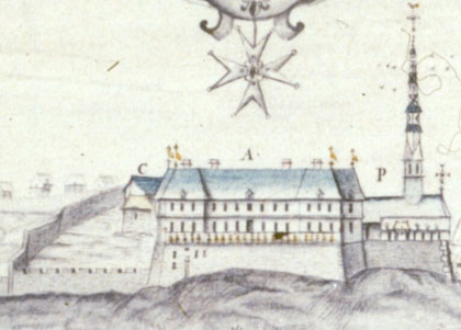 The Château St. Louis, anonymous, ca. 1700
© Library and Archives Canada, C-4696
In that regard, Frontenac was competing with monseigneur Saint-Vallier; the rivalry between the two men was well known. Saint-Vallier began construction of his bishop's palace along Côte de la Montagne, just a few hundred metres from the château.
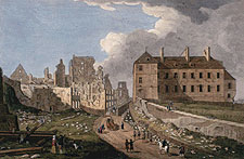 The Bishop's palace by Richard Short, 1761
© Library and Archives Canada, C-000350
For his palace, the bishop chose the form of a Parisian mansion house, adopted by aristocrats. Frontenac inherited the Château Saint-Louis from Montmagny – and hired François de la Joue, one of the city's greatest architects, to design and build the second Château Saint-Louis.
Although it may appear banal, the competition between the bishop and Frontenac regarding architecture demonstrated part of the mentality of leaders in that era. Architecture served to beautify cities, for the great glory of the king... The two edifices, which dominated the cliff, were the first to be witnessed upon arriving in Quebec City. They were also the ones to appear on engravings from which the king could determine progress in the capital of New France.
A new order at Place d'Armes
English rule brought changes that would have a major impact on the landscape of Place d'Armes: with the elimination of the intendant's palace, located in the lower town came a refocusing of the administrative functions around Place d'Armes and an end to the military role it had played since the 17th century.
In 1784, governor Haldimand built a château on the west side of Place d'Armes. A three-storey building whose plain décor integrated well with the upper city, the Château Haldimand housed a library, the governor's ballroom, and some administrative offices.
At the time, the fort Saint-Louis lost its defensive role and shared the designation as governor's residence with the Château Haldimand, housing the colony's royal representative.
Place d'Armes changed and would change again when the Récollets' monastery was destroyed by fire in 1796, and the Palladian-style Anglican cathedral was built in the early 19th century. The evolution of Saint-Louis château over the years brought changes to the landscape not only from the river's perspective but even more so from within the city.
- Date modified :