
Carillon Canal National Historic Site of Canada Management Plan, 2004
Carillon Canal National Historic Site
In 2018, Parks Canada began reviewing the Management Plan for the Carillon Canal National Historic Site, in order to comply with its legal obligation to submit a new plan by the end of 2020. Parks Canada wishes to continue discussions with community partners to better target priorities for the coming years, so that the plan expresses a common vision for the management of the National Historic Site. Consequently, the 2004 management plan for the Carillon Canal National Historic Site will continue to provide strategic management direction for the site until the finalization of the revised management plan, which has a target timeline of 2023.
Table of contents

© Her Majesty the Queen in right of Canada, represented by the Executive Director of Parks Canada, 2004.
Cette publication est aussi disponible en français.
Carillon Canal National Historic Site of Canada Management Plan, 2004.
- Catalogue No: R64-290/2004E
- ISBN: 0-662-36901-7
For more information about the management plan or about Carillon Canal National Historic Site of Canada:
230 Du Barrage Street
Saint-André-d'Argenteuil, Québec J0V 1X0
Foreword

Canada’s national parks, national historic sites and national marine conservation areas represent the soul of Canada. They are a central part of who we are and what we are. They are places of magic and wonder and heritage. Each tells its own story. Together, they connect Canadians to our roots, to our future and to each other.
What we cherish as part of our national identity, we also recognize as part of our national responsibility. All Canadians share the obligation to preserve and protect Canada’s unique cultural and natural heritage. Together, we hold our national parks, national historic sites and national marine conservation areas in trust for the benefit of this and future generations. To achieve this, practical action grounded in long-term thinking is needed.
These principles form the foundation of the new management plan for Carillon Canal National Historic Site of Canada. May I offer my deep appreciation to the vast range of thoughtful Canadians who helped forge this plan. I am especially grateful to our very dedicated team from Parks Canada and to all those local organizations and individuals who have demonstrated such good will, hard work, spirit of co-operation and extraordinary sense of stewardship.
In that same spirit of partnership and responsibility, I am pleased to approve the Carillon Canal National Historic Site of Canada Management Plan.
Recommendations
Recommended by:
Alan Latourelle
Chief Executive Officer
Parks Canada
Christina Cameron
Director General, National Historic Sites
Parks Canada
Carol Sheedy
Director General, Eastern Canada
Parks Canada
Francine Émond
Director, Western Quebec Field Unit
Parks Canada
Laurent Tramblay
Executive Director for Quebec
Parks Canada
Introduction
The Carillon Canal
A lock on a waterway
The Carillon Canal is located on the north shore of the Ottawa River, about 65 km northwest of Montreal, near the village of Carillon, which is today part of the municipality of Saint-André-d’Argenteuil. The Canal is equipped with a modern lock that enables vessels to negotiate a nearly 20-m decrease in ground level where the Carillon dam and hydroelectric power station stand.
The Carillon Canal belongs to a network of inland waterways in the eastern regions of Canada and the U.S.A.; more specifically, it is part of a circuit that links Montreal, Ottawa and Kingston.
The Ottawa River was used as a trade route by Aboriginal peoples for thousands of years. After the arrival of Europeans, it played an important role in the fur trade. In the beginning of the 19th century, a primitive canal system was built to enable river travellers to by-pass the Long-Sault rapids.
Developments in maritime traffic have led to changes in the canal system along the Ottawa River. The three original canals were at one point reduced to two in number and eventually to a single canal. This canal, the Carillon Canal, is the only component in the entire system that remains active. The growing popularity of pleasure boating has turned this site into a recreational area with a heritage value.
A national historic site
In 1925, the Historic Sites and Monuments Board of Canada (HSMBC) recommended that the development of a national network of Canadian canals should be considered as a historic theme of national significance. The Board then undertook a study of the various canals in Canada in order to elaborate a commemoration project. In 1929, the Board recommended that the Carillon Canal and 13 other Canadian canals be declared of national significance.
In 1931, the Board had a cairn erected at the entrance to the canal and on it put up a commemorative plaque that underlined the historic significance of the canal as part of a system that linked Montreal with Ottawa and Kingston via the St. Lawrence, Ottawa, Rideau and Cataraqui rivers.
In 1972, in accordance with the Agreement for Recreation and Conservation Programs, Parks Canada took over the administration of certain canals whose role would henceforth be centred more specifically on pleasure boating. Eight historic canals, including the Carillon Canal, were thus transferred, on the condition that the new administrator should manage them not simply as waterways, as they had been previously, but also as areas in which the protection, enjoyment and interpretation of heritage values were to be developed.Footnote 1
In 1987, the HSMBC decided that the commemoration of a canal should be effected in one of the two following manners: either by setting a commemorative plaque or by setting a plaque and undertaking to preserve and present specific resources of national significance, such as buildings, locks, overflow basins and dams. In announcing this decision, the Board reaffirmed that “the historic Carillon Canal was of national historic significance as a waterway belonging to the national network of canals in Canada”; however, the Board also mentioned that “commemoration by means of a plaque [would] be sufficient.”Footnote 2
In 1994, Parks Canada established its Guiding Principles and Operational Policies,Footnote 3 which, as a broad statement, defined the general principles intended to guide national programs for the development and protection of cultural and natural heritage. The policies established in this document include the Historic Canals Policy, the National Historic Sites Policy and the Cultural Resource Management Policy, which provide more detailed guidelines for managing heritage areas.
The Management Plan
The Management Plan for a national historic site identifies management measures and the general direction they should take in order to ensure that the long-term development of the site gives priority to its commemorative integrity. The Parks Canada Agency Act (1998) stipulates that Management Plans must be reviewed every five years and updated if necessary. The plans must reflect Parks Canada’s general policies, but they must also take into account viewpoints and suggestions provided by the public.
The Management Plan for Carillon Canal National Historic Site of Canada is the outcome of a planning process that began in 1996. By the fall of 1997, the projected presentation design was made public in consultations that gave area citizens information about the target objectives.
The consultations provided interested individuals and organizations with an opportunity to make their opinions known with respect to the design and directions proposed for the site. Through the comments and suggestions recorded in the consultations, Parks Canada gained fuller awareness of the viewpoints of the region’s citizens and was able take these viewpoints into account in defining the final directions of the project.Footnote 4
This Management Plan sets out various management steps to be implemented over the course of the next five years, with the principal objective of ensuring the commemorative integrity of the site. The plan is based on a long-term vision covering a period of 15 years, and it thus includes directions whose implementation cannot be envisaged at present but may eventually be made feasible by the financial situation or the establishment of the requisite partnerships.
Map 1: Beyond all borders
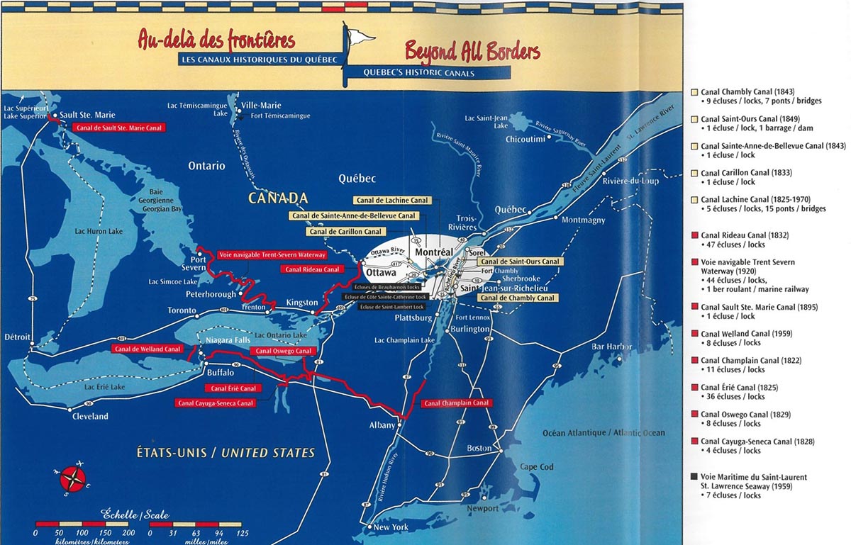
Map 1: Beyond all borders - Text version
The Carillon Canal belongs to a network of waterways in the eastern regions of Canada and the United States of America; more specifically, it is part of a circuit that links Montréal, Ottawa and Kingston.
Map 2: Regional context
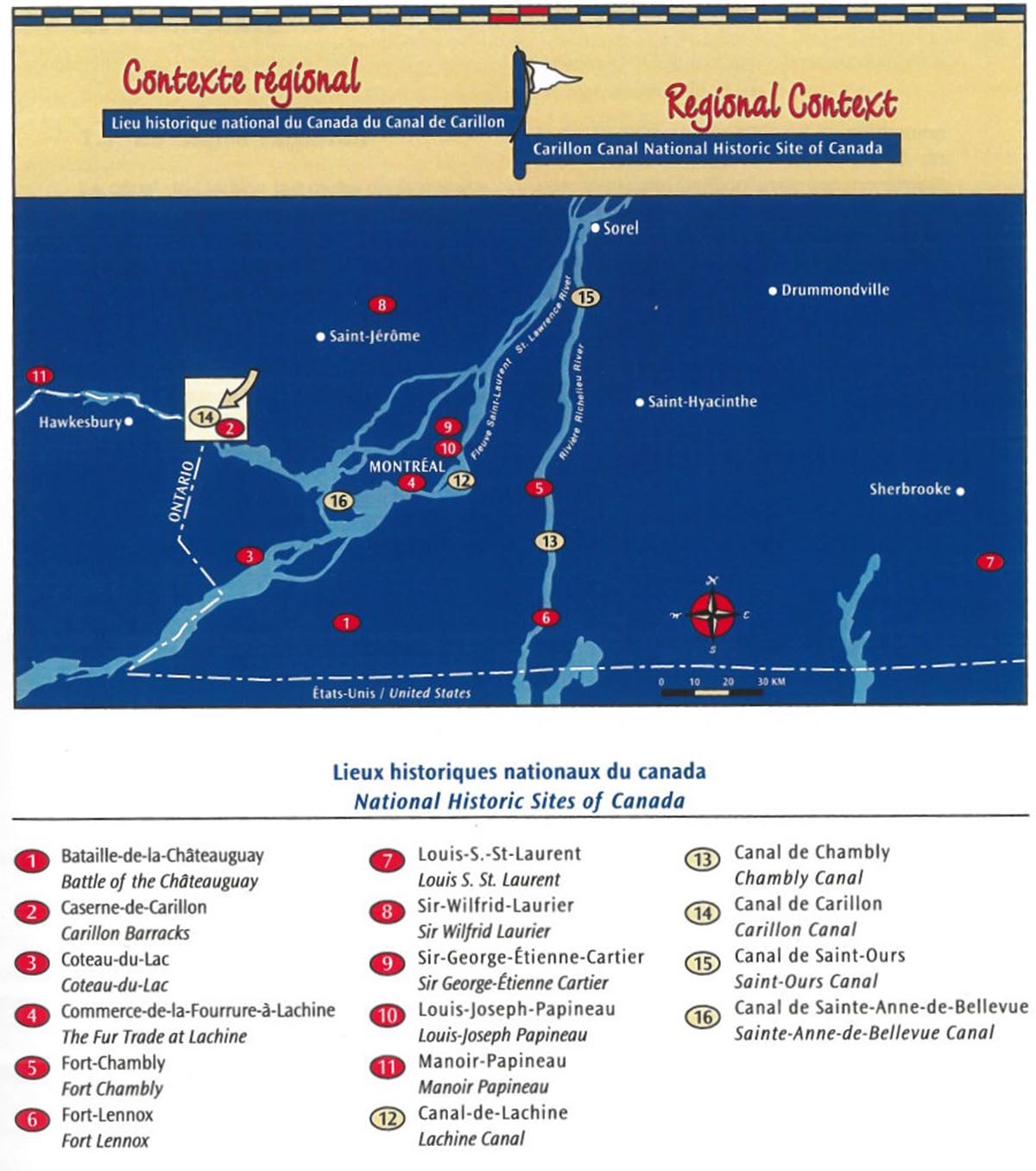
Map 2: Regional context - Text version
The Carillon Canal is one of the five historic canals that make up the network of waterways in Quebec. This national historic site, managed by Parks Canada, is located northwest of Montréal in the Lower Laurentians, along the Ottawa River.
1.0 Context
1.1 The regional context
The Carillon Canal is situated in the regional municipality of Saint-André-d’Argenteuil (itself a part of the Québec territorial division known as the County Regional Municipality of Argenteuil).Footnote 5 The canal may be reached by taking Route 344, which follows the north shore of the Ottawa River. It is also possible to take Highway 40, on the south shore, and cross the river by either the Hawkesbury Bridge (between Hawkesbury and Grenville) or the seasonal ferry between Pointe-Fortune and Carillon. Another way of going from Highway 40 to Route 344 is to take the ferry between Hudson and Oka.
The Carillon Canal lies within the West Argenteuil sector of the Laurentide tourist region. Although the canal is located on the outskirts of the sector’s main attractions, it is nonetheless central to one of the cores that define the Route 344 corridor. This route has been chosen by the Regional Municipal Counties of Argenteuil and Deux-Montagnes as a corridor in which to foster the development of tourism and heritage resources in the territory.Footnote 6
Three cruise ship lines make excursions through the Carillon lock, but they do not make any stop there.Footnote 7 The banks of the Carillon Canal are bordered by a number of attractions, including the Carillon hydro-electric power station, identified as one of the generating stations that constitute the technological and architectural heritage of Hydro-Québec; Carillon Municipal Park,Footnote 8 with its monument to commemorate the Battle of Long-Sault; and Carillon Barracks National Historic Site of Canada, which houses the Argenteuil Regional Museum. In the same region, little further up river, the old Grenville Canal is another attraction of a similar nature.
1.2 The historical context
Although the Carillon Canal was intended to serve military needs when it was built, it soon followed the pattern of other canals along the Ottawa River and, as of 1833, began to be used for commercial purposes. In the earliest period of its existence, the canal provided a means of both supplying goods to the new centres of settlement in Upper Canada and shipping products from the Great Lakes and Upper Canada to Montreal. In the 1840s, the canal was also used to transport many of the numerous immigrants who began to arrive in that period.
From 1849 to 1919, the canal’s commercial role centred mainly on shipping timber, particularly lumber from the Ottawa Valley, as well as a small amount of farm produce. After 1887, when the railroad appeared, the need to transport lumber by water gradually diminished. By about 1919, the vessels carrying wood products downstream were far fewer than those going both upstream and downstream carrying goods such as bituminous coal, sugar and salt. Between 1920 and 1929, there was a marked decline in the transportation of timber. In the 1930s, this traffic disappeared entirely; it was replaced by shipments of sand and gravel, as well as gas, oil and bituminous coal. In 1963, a new lock was opened and the canal began to be used exclusively for pleasure boating.
The present-day canal and lock at Carillon represent the most recent stage in the long evolution of the Ottawa River’s navigation system. This system is result of three major periods of construction.
The first canal system on the Ottawa River was built between 1819 and 1834. It comprised three canals and 11 locks: the Carillon Canal had three locks; the Chute-à-Blondeau Canal had one and the Grenville Canal had seven. The system was constructed by the Royal Staff Corps and was intended to facilitate the transportation of troops and their materiel between the provinces of Lower Canada and Upper Canada, or more precisely, between Montreal and Kingston, should the need arise to defend the territory against an attack along the St. Lawrence River. The locks at Carillon had a draught of 1.8 m and could accommodate boats up to 9.1 m wide. These dimensions corresponded to those of the locks on the Rideau Canal. The work carried out at Carillon in this period also included a 3.3-km-long canal, two weirs on the Rivière du Nord and a feeder canal equipped with a regulating sluice, which ensured a reliable supply of water from this river.
From 1873 to 1882, a second series of canals was built parallel to the first one, following the recommendations of the Canals Commission, with a view to improving and facilitating trade. The new system had only seven locks: two at Carillon and five at Grenville, the lock at Chute-à-Blondeau having been eliminated. At Carillon, the project involved building a canal just 1.2 km in length and two locks with a draught of 2.7 m, a length of 61 m and a width of 13.7 m, as well as a new weir with a log chute on the Ottawa River. The remains of canal installations that can be observed at Grenville date back to this period.
The present system was built in the period between 1959 and 1963. This system is part of a dam project realized by Hydro-Québec in order to produce extra electricity for peak demand in the Montreal area. The project involved constructing a new 0.8-m-long canal (in almost the same position as that of the previous canal) as well as a lock operated entirely by electricity. This lock, which enabled boats to negotiate a difference in ground level of 19.6 m, had a draught of 2.7 m and measured 57.3 m in length by 13.7 m in width. The upstream gate swung on hinged leaves, while the downstream one was a vertical lift gate raised with counterweights. Because of the new lock’s size, the canal system did not require any other locks. The Carillon lock’s features continue to make it one of the most remarkable examples of its kind in Canada.
Next to the new lock, Hydro-Québec built a hydroelectric power station in a nearly 1.2-km-long concrete dam on the Ottawa River. This dam, with a water flow capable of producing 654 500 kW, extends upstream with two jetties and an earthwork embankment. The dam caused the water level to rise by 18.9 m at Carillon, creating a vast reservoir and flooding large areas along the shoreline, so that much of what remained of the old canal system disappeared.
1.3 The site
The property belonging to Parks Canada (that is, the “administered property”) covers a surface area of almost 10 ha, bordered by Carillon Municipal Park to the east and by the Hydro-Québec facilities to the west. Footnote 9 The contiguity of these three grounds has led to a certain symbiotic use of some of the spaces and infrastructures found in them. For example, there is little differentiation between the sites with respect to picnic areas, access roads and parking. The main road out of the village leads to both the canal and the power station. The pylons for the high-tension lines stand in the central area of the site.
Another Parks Canada property, Carillon Barracks National Historic Site of Canada is situated about 300 m from the canal’s downstream gate and constitutes one of the village’s attractions. The Argenteuil Historical Society has operated a regional museum in the barracks for over 60 years. Footnote 10
Map 3: Multiphase plan
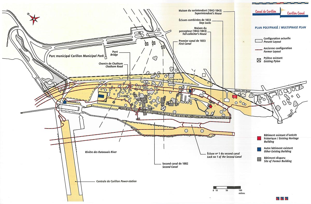
Map 3: Multiphase plan - Text version
The Carillon Canal site represents the culmination of a long evolution of the navigation system on the Ottawa River, where different periods of construction can be distinguished.
2.0 The commemorative integrity of the site
2.1 Parks Canada’s objectives
As a federal government agency responsible for preserving and developing the nation’s cultural and natural heritage, a specific objective of Parks Canada is:
“To foster appreciation, enjoyment and understanding of Canada’s historic canals by providing for navigation; by managing cultural and natural resources for the purposes of protection and presentation; and by encouraging appropriate use.”Footnote 11
Parks Canada must see that historic canals are used in a sustainable manner that does not negatively affect the protection of heritage resources. In partnership with interested groups and individuals, Parks Canada must promote the understanding, appreciation and enjoyment of heritage values related to historic canals.
The guiding principles defined in the Historic Canals Policy provide for the following objectives:
- to maintain through navigation as an integral part of an historic canal’s heritage value and to safeguard canal structures and mechanisms, as well as the operations associated with them;
- to ensure that management of the canals takes into account needs related to the protection, presentation and appropriate use of cultural and natural resources, while continuing to maintain navigation;
- to protect the cultural resources for which Parks Canada is responsible in accordance with the Cultural Resource Management Policy and uphold the principles of value, public interest, understanding, respect and integrity;Footnote 12
- to promote appropriate compatible use in order that those who visit terrestrial and water resources can enjoy and appreciate them in all seasons, without compromising heritage values and public safety concerns;
- to foster co-operation between Parks Canada and government departments, agencies, groups and individuals who are motivated by the pursuit of these objectives;
- to encourage local governments and other organizations to ensure that their plans, regulations and programs provide for protection of the heritage value of the cultural landscapes formed by the corridors constituted by historic canals and their banks.
Furthermore, as a means of realizing its mandate, Parks Canada has adopted a series of strategic objectives that will guide its activities over the course of the next five to ten years. These strategic objectives include the following:
- to ensure the commemorative integrityFootnote 13 of national historic sites;
- to inform Canadians and foreign visitors about Canadian heritage, explain commemorative integrity and help Canadians to better appreciate networks of historic sites (including historic canals), national parks and marine conservation areas;
- to provide visitors with appropriate services so that they may enjoy and appreciate heritage areas, while ensuring that the negative impact of such services is minimal.
Respect for the commemorative integrity of a site recognized as being of national historic significance is thus one of the fundamental objectives pursued by Parks Canada. A statement of commemorative integrity serves as a guide in planning and managing such a site. The statement sets out the objective of commemorating the site, describes the cultural resources found there and attributes a value to them, and finally, explains the reasons for the site’s national historic significance that should be communicated to the public. The statement of commemorative integrity also establishes the objectives to be reached with respect to protecting cultural resources and communicating the national historic significance of the site. In short, the statement of commemorative integrity constitutes a frame of reference that identifies what the ideal state of the site would be. Evaluating the gap between this ideal state and the site’s actual state makes it possible to define specific management actions for the conservation and presentation of the site.
2.2 Commemorative intent
The commemorative intent of a given site or historic canal defines what should be specifically commemorated at this site. This intent is closely related to the reasons that led the site’s being designated as being of national significance and that account for its being placed in the ranks of the national historic sites of Canada.
The commemorative intent for the Carillon Canal is defined as follows:
“Carillon Canal is part of Canada’s national system of historic canals. Located on the Ottawa River, the canal commemorates the role played by this waterway during the 19th and 20th centuries, as part of a system of canals that links Montreal and Kingston on Lake Ontario via the St. Lawrence and Ottawa, Rideau and Cataraqui rivers.”Footnote 14
2.3 Resources characterizing the national significance of the site
Parks Canada ascribes great importance to the cultural resources whose historic value has motivated the designation of a site as being of national significance. In general, such resources are related to the commemorative intent and are said to be “level 1 resources,” according to the Cultural Resource Management Policy.Footnote 15
The resources related to the commemorative intent in a national historic site can be quite diverse. They may be elements in the landscape, engineering structures, old buildings, archaeological remains or objects. However, in the case of the Carillon Canal, the existing resources cannot be considered to be of national historic significance, since they were not explicitly designated as such in the reports made by the Historical Sites and Monuments Board of Canada in 1929 and 1987.
2.4 Messages of national historic significance
The messages to be communicated to the Canadian public concerning the Carillon Canal are formulated in terms of their relation to the commemorative intent.
Contextual messages
- The Carillon Canal is part of the national system of historic Canadian canals.
- The Carillon Canal is one of many canals that linked Montreal to Ottawa and Kingston along the St. Lawrence, Ottawa, Rideau and Cataraqui rivers.
Complementary messages
As the contextual messages are further developed, in accordance with the Cultural Resource Management Policy, they should help to enrich the commemorative themes of the site. From this perspective, it is clear that the following elements should also be an integral part of the messages of national historic significance:
- The importance of the Ottawa River as a line of communication and the role of the Carillon Canal in the commercial development of the Ottawa area; the functions fulfilled by the canal, starting with its initial military role and continuing with its importance for commerce, particularly the lumber trade, in the 19th and 20th centuries as well as for transporting Canadian immigrants further inland.
- The role of the Carillon Canal as part of a local canal system that made it possible to skirt the Long-Sault rapids.
- The relationship between the Carillon Canal and the canals at Grenville and Chute-à-Blondeau.
- The construction of Carillon Canal and its history; developments in engineering that are exemplified in the canal’s three periods of construction as well as by the builders, operators and users.
2.5 Other heritage resources
The Carillon Canal is distinguished by the presence of various historical elements that bear witness to its two previous periods of development. Other historical elements have disappeared but are identified by what are presumed to be archaeological remains.
Although these heritage resources have not been designated as being of national historic significance, they nonetheless have historical significance for the Carillon Canal and are said to be “level 2 resources.”Footnote 16
Location and significant landscape
The landscape around the Carillon Canal, particularly in the lower sector of the site, reflects the site’s evolution and history, and the tangible evidence preserved in the surroundings helps to explain its national historic significance. The heritage value of the Carillon Canal’s landscape lies in the unchanged interrelationships between the various major components in the lower sector of the site, where the downstream entrance to the first canal and its old buildings still survive, as does the second canal. The main landscape elements that characterize the site are as follows:
- a portion of the first canal and the combined locks that constituted the entrance to this canal;
- the canal leading to the present-day lock, with elements related to the second canal in part of its layout and its old masonry south wall;
- the spatial and visual interrelations existing between the various historical components of the landscape, including the superintendent’s house, the toll collector’s house, the entrance to the first canal and lock number 1 of the second canal;
- the fact that the road leading to the site (Rue du Barrage) follows the path of the former river road (Chatham Road);
- the spatial and visual interrelations existing between the lower part of the site and the neighbouring village.
The natural landscape has undergone considerable changes as a result of the construction of successive canal systems and the building of the hydroelectric power station.
Despite the extent of the changes which have occurred in the landscape, certain elements have remained constant over time:
- the combination of two functional components represented by the lock and the canal;
- the relationship established between the first canal, the superintendent’s house, the toll collector’s house and lock number 1 of the second canal;
- the presence of the old Chatham Road, which has been turned into the access road leading to the site (rue du Barrage);
- the proximity of the community of Carillon and the maintenance of its village atmosphere;
- the relation existing between the entrance to the first canal, the dock for the Pointe-Fortune ferry and the Carillon Barracks.
The principal changes in the landscape occurred when the dam and power station were built, along with the new canal and the extension of an earthwork embankment downstream. The massive shape of this complex blocks the view of the river towards the northwest. Upstream from the dam, the river widens to form a vast reservoir. The landscape as it appears today can be divided into three distinct zones:
The historic core
This zone, corresponding to the entrance to the site, extends from the parking lot to the southern limits of Parks Canada’s property. It includes a section of the first canal, the toll collector’s house, the superintendent’s house and the remains of lock number 1 of the second canal. This zone is also presumed to contain the remains of some of the houses and buildings that stood here before the construction of the first canal and that are thought to have been used for canal operations after 1833, until new buildings were erected in the 1842-1843 period. Some of these remains may also be related to the two warehouses that were used in connection with the first canal. The open nature of this zone provides a clear view of every surviving element, which in turn reinforces the impression of this zone being a homogeneous whole.
The intermediate zone
This zone corresponds to the central part of the site, extending under the high-tension lines to the slope of the embankment and down to the lock. This flat area is presumed to hold the archaeological remains of a large section of the first canal as well as those of buildings that once stood nearby. These would include the dwellings already present when the first canal was constructed, as well as the houses, outbuildings and warehouses erected later along the canal’s banks. Some of the remains in this zone are thought to belong to the many buildings (houses, sheds, workshops, etc.) and installations that were directly related to the operation of the second canal and thus date from the same period. The present appearance of this zone represents a complete break with the past. Furthermore, the trees which have been planted here obscure the visual link between the canal and the river.
At one time, this zone offered a vista of the river towards the northwest because of the way the old dam was laid out in a recess of this waterway. The present dam, rising about 18 m higher than the previous one did, constitutes a considerable visual obstacle, blocking out any view of the river upstream.
The lock and dam zone
This zone corresponds to the upper part of the site, which is now on higher ground because of the dam and the consequent rising of the water level upstream. The vast majority of visitors would have a hard time of grasping the scale of changes to have occurred in the landscape since the 1960s. With its monumental size, the hydroelectric dam dominates the view and relegates the other components of the landscape, such as the canal, the lock and the flat lower stretch, to a position of secondary importance. Nevertheless, the high ground resulting from the construction of the dam has been used to build a belvedere beside the lock offering fine panoramic views both upstream and downstream. Finally, it should be noted that below ground, this sector is traversed by a section of the first canal.
The engineering and architectural structures of the First Canal
The combined locks (1830-1833)
A flight of two ashlar locks forms the downstream entrance to the first Carillon Canal. These combined locks are especially interesting since they are the only remaining examples of the eleven locks constructed during the initial period of canal building along the Ottawa River, carried out for military reasons. Built in 1830 and 1833, the locks were abandoned in 1882, when the first Carillon Canal was replaced by the second one.
The locks are identical in both shape and size to those of the locks built on the Rideau Canal in the same period. However, their structural and historic integrity have been impaired by the removal of their gates and the various mechanisms used to operate them.
In addition to these changes, the stone covering on the lock’s chamber walls was replaced during the 1960s by the Department of Transport. A good deal of the ashlar used for this purpose was taken from the locks on the Grenville canal before it was flooded as a result of the hydroelectric dam being built at Carillon in 1963.
The masonry stairs at the head of the lower lock’s west wall also underwent extensive reconstruction workFootnote 17 by the Department of Transport in the early 1960s.
In periods when the water level is low, the stone floor of the higher of the two locks is exposed. Two chain-link fences, parallel to the walls of the lock, make it safe to approach the canal at this point but also interfere with appreciation of the structure.
The layout of the First Canal (1825-1833)
The downstream entrance indicates the orientation of the first canal. The only other surviving elements of this canal are truncated wall sections that lie upstream from the flight of locks, separated by steep embankments. At one time, after vegetation had been cleared, a short length of the dried-up canal was visible, but in 1963 this section was completely filled. A small gabion section overlooks the east side of the canal at its northern end.
The Feeder Canal (1831-1833)
This structure is located outside the property belonging to Parks Canada. It is still discernable under a dense cover of vegetation at its junction with the Rivière du Nord. The feeder canal was a structure that played an essential role in the operation of the first canal, since it provided the entire system with water that it channelled away from the Rivière du Nord to the highest point along the canal.Footnote 18 This structure was abandoned in 1882.
The Superintendent’s House (1842-1843)
This stone building was constructed by the Royal Engineers and was used as their office and as a residence for the lockmaster.Footnote 19 Around 1857, the building was refurbished to become the residence of the superintendent of the Carillon, Grenville and Chute-à-Blondeau canals. The house served this purpose until 1967, when the last superintendent departed.
The house is one of the best-preserved remains dating from the time of the first Carillon Canal. It stands at the southern limits of the site, along the axis of the village’s main street. The land in back of the house looks onto the downstream entrance to the first canal. The house has been recognized by the Federal Heritage Building Review Office (FHBRO). Since the superintendent’s house has remained unoccupied for several years, the place shows signs of disuse. Although work was done to protect the building in 1992, the interior looks abandoned.
The work carried out in 1992 included consolidating the masonry, reinforcing the second-storey floor with tie-rods and propping up the first-storey floor. At the same time, work was done to prevent the infiltration of water in the roof, veranda and ventilation system.
At present, the west sidewall shows an outward bulge that will probably need to be remedied with structural reinforcement until restoration can be carried out on a more permanent basis.
The Toll Collector’s House (1842-1843)
This building was also erected by the Royal Engineers. It was used at first, as planned, for the administrative and practical needs of the Ordnance Department, but by around 1857 it began to serve as an office for the superintendent and the toll collector. In 1887, it was renovated and became the toll collector’s residence, which it remained until 1948. After this date and up to 1969, it was used as a residence for other canal employees. Then the structure once again became an administrative building, housing an office as of 1970 and a reception and interpretation centre between 1982 and 1986. For the past few years, the ground floor has served as an exhibition space, while the second floor is occupied by the offices of Parks Canada’s Professional and Technical Services.Footnote 20 This building has been recognized by the FHBRO.
Engineering structures related to the Second Canal
Lock number 1 (around 1882)
The extensive changes made when the present canal was widened and aligned towards the new lock meant that lock number 1 of the second canal was partially destroyed. Only its south wall and lower end still exist today. The south wall is now integrated into the downstream end of the jetty that leads to the present-day lock. The jetty, also built in 1882 and now used for mooring boats, has kept its original materials and appearance. However, its lower end was shortened by about 12 m and then covered with concrete around 1959-1960.
Part of the south side of the Canal’s Central Jetty (around 1880)
At the beginning of the 1880s, this wall formed the south side of the canal’s jetty between locks number 1 and 2. A rubble section on the south side of the present canal conceals the foot of this wall and its relation with the canal.
Archaeological remains
Although a systematic inventory of the in situ resources is lacking, information about the archaeological resources of the Carillon Canal is available.Footnote 21 Historical illustrations make it possible to identify certain elements. Archaeological resources lying in the ground level or underwater include engineering structures such as the upstream entrance, the bridges associated with the first canal and the dam built at the same time as the second canal. Contemporary maps also reveal the location of numerous buildings and installations that co-existed with the first or second canal. Several structures related to the operation of the second canal occupied the central part of the site from the 1880s to the 1960s. In all, it is estimated that nearly 100 traces of occupation may have survived. This does not take into account the possibility of traces of occupation from the paleohistoric period, particularly near the combined locks, where the original topography has been less disturbed.
Related components
The Carillon Barracks (1832-1837)
Located at the east end of the village, this fine masonry building is recognized as a national historic site and has been commemorated with a plaque since 1983. It was constructed for Charles John Forbes, an officer in the British Army’s supply corps, which at the time was responsible for the construction material used to build the canals along the Ottawa River. In its first 100-odd years, the building served first as barracks for soldiers and then as a residence for individuals, before eventually being turned into a hotel. Since 1938, it has housed the Argenteuil Regional Museum, which is run by the Argenteuil Historical Society.
Commemorative plaques
Carillon Canal National Historic Site of Canada has three commemorative plaques, two of which were put in place on the recommendations of the Historic Sites and Monuments Board of Canada. The first plaque was set up in 1931 on a cairn erected at the entrance to the site on the north side of Route 344; it underlines the national historic significance of the site. The second plaque was set up in 1977 on a granite monolith near the canal upstream from the lock to commemorate the Battle of Long-Sault. The third plaque is located to the north of the toll collector’s house and was set up by the Canadian Society for Civil Engineering to honour Lt. Col. Henry du Vernet, an engineer in the Royal Staff Corps, for his contribution to the construction of the canal system along the Ottawa River.
Moveable resources
These resources include archival material such as letterbooks, estimates and account books dating from the 19th and 20th centuries, as well as collections of documents, old photographs and maps that provide evidence of stages in the canal’s evolution.
This type of resource also includes a collection of some 40 artifacts recovered during archaeological excavations. These objects provide information about the construction and operation of the lock, as well as about the buildings associated with it. The collection comprises several pieces of architectural hardware.Footnote 22
Furthermore, near the site but outside the limits of Parks Canada’s property, there is a dressed stone bearing the inscription “Royal Staff Corps 1830,” which could have come from the Grenville Canal. When the hydro-electric power station was built, the Argenteuil Historical Society wanted to save some of the remains of the structures that were about to be flooded. As a result, several stones bearing inscriptions were removed so that they could be preserved and presented to the public.Footnote 23
2.6 Level 2 messages
The commemorative integrity statement for the Carillon Canal also identifies a number of level 2 messages of historic interest. These messages relate the canal to the voyageurs’ canoe route, the Battle of Long-Sault, the Vaudreuil Lock, primitive canals, the Carillon Barracks, the effect of the railroads on the canal’s history, the Carillon-Grenville reach, settlement, the generation of hydroelectric power and the log chute.
3.0 Present situation
3.1 The natural setting
The Carillon Canal National Historic Site is located close to the northeastern limit of the Montreal climatic region. This relatively southerly location means long hours of sunlight and a long growing season. The presence of the major St. Lawrence and Ottawa River waterways has the effect of moderating temperature fluctuations.
The site is part of the morphologic unit of the St. Lawrence lowlands and is located close to the southern edge of the Canadian Shield, which is characterized by an undulating relief. The earthworks lining the canal, rising to an elevation of approximately 18 metres above original ground level, are particularly prominent in the northern part of the site leading towards the raised embankment extending away from the generating station. As the result of various work, the site has been progressively reconfigured to the point that all traces of its previous contours are now buried. The limestone strata, previously visible along the edge of lock no. 2 of the second canal, have since then been buried under the earth embankments and the water mass.
Before the generating station and present-day lock and canal were constructed, the banks of the second canal were bordered with a dense cover of hardwood trees dominated by maples. This special feature gave the place a distinctive character similar to the hardwood stands in the Ottawa River valley. Only a few examples of this natural vegetation remain.
A few scattered trees, including American elms, red elms and willows, may be associated with the original natural vegetation, which is concentrated primarily along the sides of the original canal and upstream from the lock. Several elms have nevertheless been killed by the Dutch disease. A few willows demarcate the southernmost extremity between the entryway to the canal and that of the original canal of 1833.
Ornamental plants clearly dominate the present-day plant cover. These plantations coincide for the most part with the recent works completed during the period of dam construction.Footnote 24 Large clumps of shrubs decorate the southeast side of the access road leading to the dam. Cedar hedges outline the workshop yard and the northern and eastern limits of the land adjacent to the old toll collector’s house and the superintendent’s house. The site presents a somewhat artificial aspect, owing to the straight row of hedges, the shape of many individual cedars, the pattern of cedar-planting beneath the hydroelectric lines and the alignment of some of the trees.
The canal presents a synthetic, rectilinear appearance owing to the combination of the stone facing of the canal banks and the regular elimination of all vegetation attempting to implant itself there.
Only the strip of shoreline between the entryway of the original canal and the easternmost edge of the Parks Canada property has been left in its natural state. However, for the past several years, the bank has sustained severe visible erosion and work is now required in order to stabilize it.
The Ottawa River is the main tributary of the St. Lawrence River in western Quebec. Owing to its considerable flow rate, the decision was made to establish the Carillon hydroelectric generating station, which ranks tenth among Hydro-Québec’s generating stations in terms of output. Constructing it entailed creating a vast reservoir, Lac Dollard-des-Ormeaux.
The portion of the river extending upriver from the generating station over approximately four kilometres has been recognized as a fish sanctuary by the Société de la Faune et des Parcs du Québec.
3.2 Facilities and services
The Carillon Canal National Historic Site has facilities and services for pleasure boaters and visitors to the canal banks.
Access and parking
Visitors generally arrive at the site via Route 344, taking Rue du Barrage at the exit of the neighbouring town. They can also arrive via the main entrance of the Carillon Municipal Park, located a few hundred metres up, likewise after taking Route 344.
Two parking lots were built for visitors to the site. One is located on the small plateau between the historic sector and the picnic area and the other is below the present-day lock. Three small parking areas are also available along Rue du Barrage as is another one beside the old superintendent’s house. In total, the parking lots located on the Parks Canada properties provide some 70 spots. On very busy days, many visitors have no choice but to park their cars along the sides of Rue du Barrage and even along the access road leading to the top of the lock. For its part, the Carillon Municipal Park provides many parking spaces accessible from its main entryway.
Buildings
With the exception of the buildings of heritage interest described in the preceding chapter, the site has few buildings. There is a small facility dating to the construction of the present-day lock which houses the lock operators’ office, public sanitary installations and the lock control post. A building used as a workshop for canal maintenance operations is located at the edge of the lower plateau. Lastly, a garage/warehouse is located near the main parking lot, in line with the original Carillon Canal.
Facilities for the shipping lane and pleasure boating services
The lock itself is supplemented by a range of related facilities to ensure smooth sailing and site security. These facilities include:
- A quay for mooring the boats waiting to use the lock and for daytime and nighttime mooring downstream from the lock;
- A quay for daytime and nighttime mooring upstream from the lock, along the length of the eastern bank;
- A quay for mooring the boats waiting for use of the lock upstream from the lock, along the length of the western pier;
- A floating quay installed in the lock for facilitating locking.
The lock has a fire extinguishing system on the quay in the lock chamber. The facilities located upstream of the lock include, in particular, a boat launch.
Pleasure boaters have access to the sanitary facilities in the cabin, but these amenities are not very accessible for those moored downstream from the lock. Pleasure boaters have access to locking, to mooring in the daytime and at nighttime with limited service, without services for drinking water, electricity and showers. Fees are charged for the mooring and locking services; outdoor signs inform pleasure boaters of the rules and charges in force.
The activity areas and visitor services
Run during the summer season by the “Friends of the Long-Sault Heritage” cooperating association created in 1999, the old toll collector’s house has on display a few sections of an exhibit on the history of the canal. Most of the exterior interpretation panels had to be removed from the site due to their age and deteriorated state. Generally speaking, all of the site’s interpretation facilities are currently in a state of disuse. It should be noted that the lock operators participate in welcoming and informing visitors arriving on the site via the lock.
Parks Canada provides several picnic areas for users; they are furnished with tables, garbage cans, etc. The main area is located on the lower plateau, beneath the hydroelectric lines; it looks out directly over onto the canal, thus affording views of the pleasure craft entering or leaving the lock. However, there is no service building close by.Footnote 25 The upper plateau has a small picnic area located on the eastern bank of the Dollard-des-Ormeaux reservoir, upstream from the lock. Picnickers have access to the sanitary facilities of the small operations centre; however, access to the terrace above the lock is on a fee basis.
Lastly, there are a few picnic tables installed in the area around the toll collector’s house and the entryway to the original canal. This area is particularly appreciated for the shade provided by its large hardwood trees and for its view onto the river as it flows downstream.
3.3 Visitation
The present-day clienteles
In 2000, the overall site attendance, including pleasure boaters and visitors to the banks, was estimated at close to 35,000 visits. This number included some 12 300 pleasure boaters—that is, a decrease of 20% in comparison with the average of the preceding three years—while visitors to the banks numbered some 22 600 persons, an increase of on average 3 700 visitors in comparison with the 1997 and 1998 seasons.Footnote 26 Despite its impressive size and large capacity, the Carillon lock receives all in all few pleasure boaters, and the number of locked boats remains quite low (4 200 boats in 2000, that is, a reduction of 21% in comparison with the average of the three preceding seasons. Visitation is concentrated primarily around the months of July and August.
Even though these visitation figures indicate an appreciation of the place by a recurrent clientele, the Quebec canals “are experiencing (in differing degrees, however) visitation based on repeat users. Today’s clienteles show few signs of renewal.”Footnote 27 The last study made of Carillon Canal users dates back to 1994.Footnote 28 The principal data it reveals for that period are:
- More than 83% of the approximately 15,000 pleasure boaters who had transited through the Carillon lock made no stopover on the site, unlike what occurs at Sainte Anne de Bellevue, for instance.
- Most of the pleasure boaters were nautical tourists taking a trip of on average six nights; the boats had on average three passengers on board.
- Nearly a quarter of the pleasure boaters were from the local vicinity or the region; more than a quarter came from the Island of Montreal or Laval, while 39% came from other regions in Quebec, 8% from Ontario and only 2% from the United States.
In 1994, most of the visitors to the banks were, according to the study, repeat customers who, in the course of their visit lasting an average of two hours and 15 minutes, partook of three main activities. In order of importance, these were: watching the boats and lock, having picnics and relaxing.Footnote 29 At the time of the survey, visiting the heritage attractions constituted only a secondary activity and this trend has continued. Then as now, few visitors to the banks indicated an intention to go to the Carillon Barracks National Historic Site of Canada.
Comprised mainly of excursionists from the greater Montreal region and the Laurentians, the visitors to the banks indicated that they had come to the Carillon Canal to enjoy its green spaces and because it was a regional tourist attraction. For a little less than half of these people, the site was their main destination point.
Map 4: Current situation
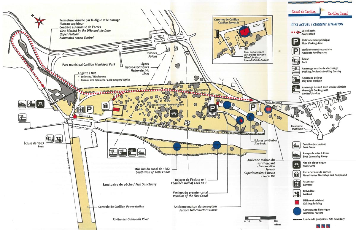
Map 4: Current situation - Text version
The Carillon Canal National Historic Site has facilities and services for recreational boaters and visitors of the canal banks, as well as several buildings of heritage interest (Former Toll collector’s House and Former Superintendent’s House).
4.0 Issues and strategic directions
4.1 The major issues
4.1.1 The commemorative integrity of the site
The Carillon Canal is a national historic site whose heritage value is barely perceptible and relatively unknown to visitors. The location of the site on the banks of the waterway, the presence of vast green spaces and the nautical activity generated by the presence of the lock represent significant poles of attraction for a clientele in search of a relaxing outdoor experience. Moreover, the priority that has been accorded over the past several years to facilities protecting the security of visitors on pleasure boats or onshore, as well as the relatively modest investments that have been made towards protecting and presenting the heritage valueFootnote 30 of the place, have helped confer on the canal an image primarily centred on its recreational attractions.
4.1.2 Integrating the site into its local environment
The Carillon Canal National Historic Site of Canada is surrounded by two neighbouring properties belonging to key local organizations: the Municipality of Saint-André-d’Argenteuil, owner of the Carillon Municipal Park, and Hydro-Québec, which operates the Carillon Generating Station. The Municipality of Saint-André-d’Argenteuil has recently completed the first development phase of its municipal park and it plans, in the next few years, to develop the recreational and tourism potential of the huge woodlands which stretch as far as the Rivière du Nord and which will eventually be traversed by the “Route verte” linking Gatineau to Montreal. Over the past several years, the Municipality has sought the agreement and co-operation of Parks Canada to reconfigure the different means of access to the site and to establish a single fee structure for users. The Hydro-Québec facilities in Carillon consistently generate a certain level of activity; every day, employees and suppliers enter the site by Rue du Barrage and during the summer season, the generating station is open to visitors in its capacity as a Quebec industrial heritage site.
4.2 Strategic directions
4.2.1 Conserving and presenting the significant landscape
- Strategic directions
- Set aside part of the grounds currently reserved for landscape for revealing the heritage character of the site and communicating its historical significance, while continuing to respect the spatial structure, the arrangement of the natural and cultural components and their interrelationships.
- Identify and highlight the special meaning of each part of the landscape in keeping with its historical significance.
- Maintain the visual relationships of the principal spaces, the areas for circulation and activity and the main buildings with the present-day canal, the original canal and locks and the Ottawa River.
- Ensure that future improvements take into account the configuration of the site in former times and respect its heritage character.
- Make the Municipality of Saint-André-d’Argenteuil aware of the importance of preserving both the scale and character of the built environment surrounding the Carillon Canal.
Key considerations
The Carillon Canal landscape symbolizes the overall historic national importance of the place. It illustrates the strong interrelationship between the different natural and cultural components and reveals the ingeniousness of a system of canalization, the evolution of technological means and the diversity of motivations that drove its builders.
The site divides into three main parts with opposite characters. The first, forming the entrance, is a core zone of heritage character; the other two are organized along more modern lines in keeping with dictates of the hydroelectric facilities and their access roads.
Although to this day the canal has remained functional, at this point the site does not evoke much of the advanced age of its functions. Overall, the visual aspect of the site has little historical flavour to it, and the site’s operational and recreational aspects greatly predominate.
4.2.2 Preserving and presenting cultural resources
- Strategic directions
- Encourage the perception of the Carillon Canal as a historic canal by preserving and presenting its significant cultural components, which testify to the role the canal played in both the Ottawa River waterway and the national waterway system.
- In general, protect the “level 2” cultural resources according to the principles and practices of the Cultural Resource Management Policy and communicate the historic value of these resources to the public.
- Institute a conservation and maintenance program for the engineering works associated with the first two canal systems as well as for the administrative, functional and residential buildings, including the archaeological remains associated with them.
- To the extent that it is possible, see that the archaeological resources are evaluated and protected.
- Encourage third-party initiatives in the identification and protection of the remains of the supply canal.
- Find a use for the old superintendent’s house that is compatible with its character as a historic building.
- Relocate elsewhere on the site the various elements (garage, picnic tables, vending machines, etc.) whose present-day location in the historic zone of the site is incompatible with the objective of highlighting its heritage character.
Key considerations
The development potential of the cultural resources centres primarily on one core component: the original canal. Although this canal lies at some distance from the present-day lock, its development potential should prove to be rich, given the number of resources present, their significance, their integrity and their harmonious blending within a structuring core.
The engineering works and the heritage buildings are for the most part in relatively good condition. The heritage structures are intact and their walls solidly built; nonetheless, the first signs of degradation have become visible and it will be important to take the measures necessary to prevent these structures from further deteriorating. The state of the archaeological resources remains unknown for the time being because no inventory has been made of the site.
The state of the combined locks and of the original canal places limits on the links existing between the toll collector’s and superintendent’s houses, since the previous bridges and doors to the lock have disappeared.
The surrounding landscape has been remodelled in step with modifications made to the dam, causing a break in the historical continuity of the canal. The almost 20-metre drop in ground level at the present-day lock allows pleasure craft to navigate the Ottawa River all the way to the Rideau Canal, an itinerary which a century ago entailed clearing no fewer than 11 locks. Today’s lock thus brings to light the magnitude of past canal systems.
4.2.3 Communicating heritage messages and values of the site
- Strategic directions
- Design and offer a visiting experience in keeping with the particular character of the site, while also taking steps to ensure it fits into the network of Canadian national historic sites.
- Present messages of national historic importance to visitors in such a way that they clearly understand them.
- Give priority to the optimal use of resources which symbolize and characterize the national importance of the site and ensure that the links between its cultural resources, history and national significance be understood.
- Implement methods and instruments of evaluation to determine the effectiveness with which messages are conveyed.
- Enrich the visit experience through the possible discovery of the remains and artifacts associated with the two first periods of canalization, as a complement to the educational messages contained within the external and exhibit panels or modules.
- Upgrade the training given to the lock operators with respect to the services and information provided to pleasure boaters.
- Develop, with the help of outside resource people and groups, the cultural programming on the site, by means of periodic activities and events that have a heritage character and that therefore serve as support for the interpretation efforts.
Key considerations
Pleasure boaters are informed about the Carillon Canal’s heritage by the lock operator, who has been trained to communicate the site’s history. On-shore visitors are familiarized with the canal’s history through the various activities provided by the “Friends of the Long-Sault Heritage” co-operating association and the exhibit in the old superintendent’s house; this exhibit should be completely renewed, however. To date, few efforts have been devoted to preserving and presenting the heritage sector of the site, with the result that it receives few visitors. These factors notwithstanding, it should be noted that the Argenteuil Regional Museum staff provide support in interpreting the Ottawa River canal system.
Overall, the history of the site and the scope of the canal works are too little known, even though lock operators help communicate it and the co-operating association plays an active role locally. Visitors are more inclined to view the Carillon Canal as a space for greenery and water, a nice place to take a walk, have a picnic and watch the boats go by.
At this time, it is not possible to mesh the development of a heritage-character experience for the Carillon Canal with a structured regional network of cultural organizations. Nonetheless, the Argenteuil Regional Museum, located in the Carillon Barracks National Historic Site of Canada, and research on ways to present the remains of the Grenville Canal both indicate the interest of local parties in offering a sector-wide heritage experience for tourists. In addition, the dam and generating station adjoining the site are components of Hydro-Québec’s network of built and technological heritage places.
In recent years, efforts have been made to reach those who, for various reasons, are unable to come to the site in person. These outreach efforts consist essentially of a website, launched in May 1997, which provides a brief overview of the site’s national historic importance.
4.2.4 Conserving natural resources
- Strategic directions
- Preserve the green, peaceful setting of the spaces.
- Promote the naturalization of the site by putting a halt to the trimming of cedars and the clipping of shrubs on the riverbank south of the entryway to the original canal.
- Collaborate with the Société de la faune et des parcs du Québec in order to increase public awareness of the richness and diversity of the ichthyological fauna of the Ottawa River as well as the presence of the sanctuary.
- Stabilize the bank area located between the entryway to the original canal and the easternmost extremity of the Parks Canada property.
Key considerations
The Carillon Canal has few natural resources. The scale of the embankments required to establish the dam, coupled with the subsequent flooding of the waterfront, led to the transformation of the original environment of almost the entire upper half of the site.
The original plant cover remaining on the site consists of but a few scattered trees, located mostly around the original canal, whereas in days now long past, clusters of hardwood trees overhung the second canal and provided shade. The rest of the site is distinguished by mature ornamental vegetation. Taken together, these elements provide a verdant setting appreciated by visitors and favourable to outdoor recreation and relaxation. However, in the area surrounded by the pylons, the trimming of the numerous cedars and their sparse distribution create an overall artificial appearance.
The principal natural resource of importance is located within the Ottawa River proper. A fish sanctuary stretches out from the foot of the dam for approximately four kilometres; its presence means that all fishing is prohibited there during the reproductive period of various species. Likewise, the Société de la faune et des parcs du Québec forbids fishing during any season from banks located on properties administered by Parks Canada. However, visitors do have access to a private outfitting business at the southernmost edge of the canal, with the option of boat rental.
4.2.5 Site visitation and use
- Strategic directions
- Promote the expansion and renewal of clienteles by re-establishing a balance between the recreational and heritage dimensions of the site, by maintaining the interest and sense of belonging of the existing clientele, and by offering a high-quality product.
- In collaboration with partners, develop new products related to the history of the canal and the Ottawa River waterway.
- Enrich the experience of pleasure boaters with a heritage experience, at the lock and along the canal banks.
- Raise the profile of the eastern Canadian historic canal network among pleasure boaters from Quebec and beyond.
- Promote the crossover of both clienteles and services between the different sites in the area.
Key considerations
Services for pleasure boating
The Carillon Canal affords pleasure boaters the opportunity of a safe, secure stopover, thanks to the availability of locking and of mooring facilities day and night. Nonetheless, the number of mooring places can be insufficient during busy periods, which leads to conflicts between the people using the quay. The daytime and nighttime mooring services remain limited, moreover, and the lock’s limited opening hours effectively hamper the use and enjoyment had by pleasure boaters.
Visitor activities and services
People making use of the banks occupy themselves mainly with watching the boats manoeuvre and the locks operate, along with picnicking and relaxing. For the most part, the spaces available look out onto the Ottawa River and would lend themselves to the development of cultural activities complementary to the recreational opportunities currently available. Activities showcasing heritage are little developed.
At the Carillon Canal, the operation of the lock is quite a spectacular experience. Given the significant drop in ground level and the unusualness of its counterweight system, the lock could become a technological attraction for pleasure boaters and visitors on the banks.
More than half the visitors on the banks see the Carillon Canal simply as a place to pass through. The level of services and the nature of activities on offer contribute to its limited image as a destination point or even as a place to stop over.
Visitors do not have access to any sanitary facilities on the site itself, other than the cabin at the lock. Recently, the neighbouring facilities of the Carillon Municipal Park have begun to cover this need.
Because the picnic spaces are tucked between the Parks Canada and the municipal park properties, they are used by the clientele of both places. Given this situation, the Municipality of Saint-André-d’Argenteuil hopes to sign with Parks Canada and Hydro-Québec an agreement establishing the sharing of parking spaces and the instituting of uniform, systematic fees for all users.
Potential clienteles
When it comes to pleasure boating, the main source of potential markets consists in those owners of pleasure boats located along the Ottawa River route and in the rest of Quebec, especially including the Montreal region.
As is the case for other shipping routes, developing and promoting the circuit of Quebec historic canals and raising the profile of its Ottawa River route are potential means of attracting pleasure boaters from Quebec and beyond. This being said, the passage through the St. Lawrence seaway locks represents an obstacle to use of the Ottawa River route. In this connection, the recent reopening of the Lachine Canal to pleasure boating should make it easier to transit between the Richelieu and Ottawa River routes.
Theme cruises represent a potential worth exploring. In addition, with respect to cruises between Montreal and Ottawa, the Manor Papineau National Historic Site of Canada and the Plaisance Park might well hold out a sizeable power of attraction.
Neither the immediate and regional tourism environment nor the local road system servicing the Carillon Canal lend themselves strongly to major movements of tourists; indeed the latter are viewed as being secondary or marginal considerations. Faced with competition by the attractive Montreal, Ottawa/Gatineau and Central Laurentians regions, the area surrounding the canal region is fairly inaccessible, despite the proximity of Highway 40 and the Montreal market.
The dam’s visibility, both in the countryside itself and as an object of publicity and marketing, adds to the canal’s attractiveness and could thus possibly foster a crossover clientele. A combination of factors could provide the initial basis for developing visitation at the canal and enhance its drawing power; for example: the campground in Chatham, the possible development of the old Grenville canal, the outfitting business, the Carillon Municipal Park with its development projects, the Argenteuil Regional Museum and the proximity of the “Route verte,” all of which are all connected to Route 344, destined to become the backbone of a recreo-tourist and heritage development route along the Ottawa River. The integration of the Carillon Canal into the development and showcasing of the Long-Sault “tourism pole” also represents a potential for co-operation.
4.2.6 Enhancing the site’s architecture and landscaping
- Strategic directions
- Reinforce the distinctive character of the Carillon Canal by means of an architectural and landscaping motif that is consistent, coherent and significant while respecting the patrimonial values of the resources in place.
- Consolidate the core heritage zone around the entrance to the original canal.
- Preserve and present the exterior architecture of the old toll collector’s and superintendent’s houses.
- Create a pedestrian link between the old toll collector’s and superintendent’s houses.
- In collaboration with Hydro-Québec, improve the character of the visiting area around the lock and of its access point area.
Key considerations
The only buildings of interest, in terms of heritage, are the old toll collector’s and superintendent’s houses. Their recognition by the FHBRO testifies to their integrity, even if they have not undergone any restoration and have lost some of their original exterior characteristics. This being said, they do not at this point hold much power of attraction given the current lack of a designated use for the old superintendent’s house and the poor state of the thematic exhibit in the old toll collector’s house.
A picnic area separates the heritage sector from the present-day lock, with the effect that the site’s spatial organization lacks coherence and character. Since, overall, the landscaping and architecture lack a unifying motif according with the spirit of the place, the site offers little with which to express the cultural values of the core heritage zone.
Few facilities and no particular furniture have been installed to encourage the watching of boats or lock, either at the lower level, along the canal, or on the upper level. This deficiency is to be noted on both sides of the lock.
Moreover, the current organization of traffic and parking, which is disproportionate to the site as a whole, is a particular source of headaches: cars are parked indiscriminately all along the roadways and, during busy periods, traffic jams occur on the upper level. The clienteles visiting the different areas are segregated. It is currently difficult to detect the access point of the lock, although the existing elevator does provide a potential access point for some visitors such as the elderly and the disabled.
As the result of efforts to enhance the security around the dam installations, chain link fences were erected and access to the lock is now subject to controls. These factors, combined with the omnipresence of asphalt and concrete, impoverish the architectural vocabulary around the lock’s visiting area. Improving the character of the access point to the lock entails close collaboration with Hydro-Québec.
4.2.7 Site management and cooperation
- Strategic directions
- Take advantage of every opportunity for third-party co-operation to oversee site management and development, by mandating partners to provide activities or services that relate to or complement Parks Canada objectives.
- Consolidate existing collaborative agreements and create new ones, especially having to do with developing regional tourism and promoting culture and boating.
- Establish formal mechanisms fostering co-ordination and collaboration with the Municipality of Saint-André-d’Argenteuil and Hydro-Québec.
- Collaborate with the Municipality of Saint-André-d’Argenteuil and Hydro-Québec in finding a solution, viable and equitable to all parties concerned, for harmonizing access and fees for the entire Carillon site.
- Outline a framework for co-operation, establishing selection criteria for projects and partners as well as intervention criteria for partners on Parks Canada properties.
Key considerations
Sustaining the interpretation and access to the exhibit in the toll collector’s house has required the involvement of various collaborators, and will continue to do so in the future. In fact, co-operation and the creation of strategic alliances constitute essential methods, given the context of Parks Canada no longer being able to do the work of developing and operating canals by itself.
The overlapping access points of the lock and dam, and their shared clientele with respect to interpretation, enhance the potential for cooperation between Parks Canada and Hydro-Québec. Moreover, given the context of rationalization of resources and the complementarity of their facilities, Parks Canada and the Municipality of Saint-André-d’Argenteuil have every interest in strengthening the ties between the national historic site and the Carillon Municipal Park in order to harmonize the different services offered to visitors and tourists.
Parks Canada is well positioned vis-à-vis regional organizations and business people, thus giving it an edge when it comes to pooling and co-ordinating any efforts to structure new products, especially in the cultural and nautical fields.
Looking towards the future:
The Carillon Canal National Historic Site at the dawn of the 21st century
In the year 2015, the Carillon Canal is a national historic site that is recognized and much frequented because of its heritage value and varied cultural, recreational and nautical functions.
The preservation and presentation of the resources related to the three periods of canal building and canal operations provide visitors with an opportunity to discover, appreciate and learn more about the role played by the canal in the Ottawa River waterway and, at the same time, to grasp the canal’s national historic significance.
The Carillon Canal represents a major heritage attraction in the region. The uniqueness of its varied functions and the high quality of its facilities and programs make it a remarkable cultural site that considerably enhances the regional heritage route along the Ottawa River. The site is of great interest to the local and regional population, as well as to tourists. The pleasure craft that dock there or travel through the lock hail from every region of Quebec and from many places outside the province thanks to the site’s growing reputation as destination.
The layout and facilities of the heritage sector provide it with a historical atmosphere that is recognized and appreciated by visitors.
The surrounding landscape offers an attractive setting for the enjoyment of recreational activities. Visitors may linger in the broad green space in the centre of the site to relax by the side of the canal or can walk along a path that leads from the heritage sector to the main canal and acts as a bridge between the past and the present. The interpretation of the lock affords insight and perspective on the impressive scale of the old regional canal system. The belvedere on the lock acts like a magnet on visitors eager to take in the attractive surroundings. Those travelling by pleasure boat or cruise ship experience the excitement of passing through the lock and quite naturally see it as a place where they plan a stop to relax and enjoy a heritage site.
The partners involved in the site include various levels of government, the CRM of Argenteuil, the Municipality of Saint-André-d’Argenteuil, the co-operating association of “Les amis du patrimoine du Long-Sault,” Hydro-Québec, private enterprises, local organizations and community groups. These bodies form a close network of partnerships focused on attaining shared goals. By working together and sharing various responsibilities, these partners reinforce the Carillon Canal’s ties with its community and enhance its attraction for the local and regional population, as well as for tourists. All the parties involved contribute to the harmonious management of the site so as to ensure that it remains a place where culture, nature and recreation can be experienced and enjoyed in equal measure.
5.0 Presentation
The main goal of the presentation concept prescribed for the Carillon Canal National Historic Site of Canada is to ensure the commemorative integrity of the place. The concept takes the following factors into account:
- Parks Canada objectives in accordance with the “Historic Canals Policy” and the “National Historic Sites Policy;”
- The Cultural Resource Management Policy;
- The long-term vision outlining the desired state of the site;
- The commemorative intent of the site;
- The site’s potential and limitations;
- The general orientations established for the presentation and management of the site.
The presentation plan for the Carillon Canal National Historic Site of Canada is based upon the following key elements:
- Consolidating a core cultural zone around the entryway of the original canal and the surviving historic buildings;
- Consolidating a core recreational zone centred on the lock;
- Consolidating the nautical aspect of the canal;
- Consolidating the extensive use of the central plateau and the area beside the “Dollard-des-Ormeaux” reservoir.
5.1 The core cultural zone
Parks Canada aims to provide the Carillon Canal National Historic Site of Canada with a structuring core of cultural activities organized around the entryway to the original canal and the old toll collector’s and superintendent’s houses. These activities will be focused on communicating the site’s heritage values so that visitors understand the national historic importance of the canal as well as the role it played in the Canadian interior navigation system.
Consolidating the core cultural zone will table on the presentation and interpretation of the remains of the original canal’s entryway and of the combined locks that are associated with the original Ottawa River canal system. The project will also rely on the presentation of the buildings of historic interest. Depending on the state of the archaeological resources and the costs involved, this presentation of the first period of canalization could also extend to the remains of the original canal located along the access road as well as to the presumed remains of the buildings related to the operation of the second canal.
The old toll collector’s house will display a renewed exhibit on the history of the Carillon Canal, serving as a complement to the “heritage itinerary” (exterior modules and panels installed on the site), while the old superintendent’s house will be given a use compatible with its heritage value. This could include a shared occupation of premises and could also offer favourable opportunities for financial involvement on the part of the future partners. The work to be undertaken on each of these buildings will be preceded by a conservation/restoration concept that puts into practice the cultural resource management principles in force at Parks Canada.
Re-enhancing the exterior architecture of these two historic buildings and eliminating the parking lot adjacent to the old toll collector’s house will help enrich the heritage character of this core cultural zone. A pedestrian link will allow the lock to be crossed over and will tie the two residences together.
The cultural function will also extend to the already-existing walkway that runs the length of the canalized section, as it is a favoured location for interpreting the second period of canalization—in particular, the traces of lock no. 1 of the second canal.
Presenting the original canal remains and the two buildings of historic interest, in conjunction with establishing an outdoor interpretation itinerary and various landscaping works, should serve to create a veritable museum of the site within the core cultural zone. The interpretation concept/ plan to come will provide more details in this regard.
On the lock site, the interpretation program will be enriched by informing the public of the third period of canalization. The lock operators will continue to participate actively in interpreting the Carillon Canal to pleasure boaters during locking manoeuvres. Particular events could be staged, thus providing an opportunity for communicating the canal’s heritage values.
In addition, the Parks Canada website will continue to be upgraded periodically so as to enable people unable to go to the site to learn about and understand its commemorative intent and the related heritage values.
5.2 Access and parking
Rue du Barrage, which runs along the same route as the road used when the canal was constructed, will continue to serve as the entryway to visitors to the national historic site and the present-day parking lots will for their part be kept. The intent to keep Rue du Barrage as the main access point for the place could be modified in the eventuality that Parks Canada, the Municipality of Saint-André-d’Argenteuil and Hydro-Québec come to agree upon new modes of access for the whole site. More precise direction with respect to access, visitor reception and parking will be proposed in the next management plan revision process; these directions will take into account, where applicable, possible future agreements concluded between Parks Canada and its partners in the vicinity.
5.3 Navigable way
In conformity with its current use, the canal will be used for pleasure boating, for cruise itineraries or boat excursions as well as complementary uses compatible with Parks Canada objectives and the character of the place.
Consolidating the nautical aspect of the Carillon Canal might at some point mean installing additional pontoons downstream from the lock so as to provide a means for short-term daytime mooring.
Pleasure boating and the other water-related activities will have to be compatible with protecting and presenting the cultural resources. The security directives posted at the approach of the dam and upstream and downstream of the lock will have to satisfy the requirements of Hydro-Québec.
The provision by private partners of thematic cruises and excursions related to the history of the canal and of the region should prove to be a worthwhile side attraction.
The rental of recreational boats, provided by third parties, could be considered for the quay upstream from the lock, in order to provide access to the water of the reservoir. In any case, the kind of boat available for rent should not become a source of problems for, or conflicts with, canal users. Renting personal watercraft (PWC, or “jet skis”) will not be permitted; likewise, water skiing and swimming will be forbidden inside the limits of the property administered by Parks Canada. In addition, the use of recreational rental boats will be controlled and will be forbidden upstream from, and alongside, the lock as well as downstream starting from the entryway to the present-day canal.
5.4 Use areas
The central part of the lower plateau will continue to be a natural zone reserved for “free” or “informal” activities, that is to say, recreational and non-organized activities requiring any structure sport-or-competition-related framework or any major infrastructure. In the short or medium term, there are no plans to install new public toilets in this sector, given that users have access to those available in one of the service buildings in the neighbouring municipal park.
The central portion of the plateau could also be used for events and gatherings held as part of recreational or cultural activities or special festivities. Light temporary facilities will be set up for such events. An area reserved for canal maintenance will be located at the upstream edge of the central zone.
Fishing will not be permitted from the reservoir, canal and riverbanks inside the Parks Canada property limits, given its potential for conflicts with pleasure boating. However, fishing is allowed on the Ottawa River outside of the aforementioned limits, in conformity with provincial regulations in force.
6.0 Summary of the management plan’s environmental assessment
6.1 Context
The Management Plan for Carillon Canal National Historic Site of Canada has undergone a strategic environmental review in accordance with the Cabinet Directive entitled “Environmental Assessment Process for Policy and Program Proposals.” This federal environmental assessment process is a self-evaluation mechanism used by federal departments and agencies to determine, assess and generally minimize the environmental impacts of projects or activities they plan to undertake. In accordance with Parks Canada’s Management Directive 2.4.4 on impact assessment, the scope of these environmental assessments extends to cultural resources, so that all the factors bearing on the assessment are included in the same report. The environmental assessment of this Management Plan is presented in a separate document entitled Évaluation environnementale stratégique du plan directeur du lieu historique national du Canada du Canal-de-Carillon (Strategic Environmental Assessment of the Management Plan for Carillon Canal National Historic Site of Canada). The following sections provide a summary of this document.
6.2 Methodological approach
The environmental assessment of the Management Plan was carried out in several stages. The first consisted of determining the scope of the assessment with respect both to the elements to be considered and to the temporal and spatial limits of the exercise. Then the general directions presented in the Management Plan were examined to ensure that they accorded with the mandate and policies of Parks Canada. The next step involved identifying the stressors that might result from the presentation of Carillon Canal National Historic Site. These potential impacts were defined by using a matrix that showed the relationship between elements of the Management Plan and components of the receiving environment. The impacts were then characterized according to their duration (temporary or permanent impact) and intensity (no impact, weak impact, impact that could be mitigated or not, or unknown impact). The cumulative effect of these impacts was assessed by determining to what degree the interaction of certain elements in the Management Plan would contribute to improving or impairing key components of the environment. Finally, general measures intended to reduce anticipated negative impacts were defined.
6.3 Scope of the environmental assessment
This environmental assessment is based on existing documentation as well as on the opinions of various specialists in the management of cultural and natural resources. The assessment takes into consideration both biophysical resources (soil, air, water, terrestrial and aquatic vegetation and wildlife) and cultural resources (cultural landscape, built heritage, archaeological resources and commemorative integrity). However, the study of cumulative impacts deals only with the resources that are considered significant in the environment.
6.4 Compliance of the management plan’s strategic directions
The preservation of commemorative integrity is the keystone of Parks Canada’s mandate with respect to national historic sites. The statements presented in the Management Plan for Carillon Canal National Historic Site of Canada in no way compromises this integrity. Indeed, on the whole, they provide support for this component of Parks Canada’s mandate. Nonetheless, two of the recommendations could eventually come into conflict with the objective of ensuring the commemorative integrity of the site. These recommendations are:
- to lay out a foot path between the toll collector’s house and the superintendent’s house;
- to strengthen existing co-operation agreements and establish new ones, especially those whose goal is to encourage tourism and promote the site as a cultural and nautical destination.
Furthermore, the services and activities available for a fee on the site and in the surrounding area may have an impact on other common activities that are directly related to Parks Canada’s mission and that take place on the site. For example, powercraft rented beyond the boundaries of the site could lead to a considerable increase in noise levels, which in turn could interfere with holding an activity like guided tours in certain sectors of the site.
In the Management Plan for Carillon Canal National Historic Site of Canada, there are no natural resources that are identified as having a special significance. In any case, the general directions presented in the Plan do not in any way compromise the preservation of these resources.
6.5 Identifying impact sources and evaluating preoccupations
The study of anticipated impacts on natural resources showed that setting up new facilities for visitors would have a positive effect with respect to communicating the site’s heritage values. The more negative impacts of such facilities are related to an increase in the quantity of waste resulting from an anticipated rise in the number of visitors, as well as the uses to which the facilities will be put. For instance, the occupation of the superintendent’s house will entail dealing with wastewater, solid waste and electricity consumption. Other negative impacts include higher noise levels and water pollution (for example, as a result of powercraft rented in the surrounding area).
The improved service offer should bring about noticeable increases in the number of visitors to the site, as well as in the amount of time they spend there and the activities they engage in. The fact that more visits will take place in a given time and space may have an effect on the vegetation cover to varying degrees, depending on the sector. The addition of interpretation panels outside in the historic zone should take into account the presence of what are presumed to be archaeological remains in this sector and should not interfere with enjoyment of the cultural landscape.
The development concept recommended by the Plan should normally help to improve the present heritage context, both on the site and in the surrounding area.
6.6 Mitigation strategies
To counteract the probable negative impacts of presenting the site, the following strategies should be adopted:
- bare patches on the ground should be re-sodded or protected by accepted techniques such as laying down biodegradable membranes;
- the mitigation measures recommended in studies made previous to projects and activities should be implemented so as to minimize potential negative impacts on cultural resources.
6.7 Conclusion
This strategic environmental assessment makes it possible to distinguish the principal impacts that are likely to have an effect, on a one-time basis or cumulatively, on the environment and, to somewhat lesser degree, on the biophysical resources. The strategies and measures for mitigating these impacts, as proposed in the plan, should serve as a frame of reference and guide management in the actions it undertakes to counteract the stressful effects of implementing each project and activity in accordance with the objectives of Parks Canada’s mission.
In general, the proposals put forward in the Management Plan correspond to the policy requirements of programs that have been based on Parks Canada’s mandate. The impacts on the natural and cultural environment of the site are for the most part positive. Those that are not can generally be mitigated through the implementation of appropriate measures and accepted techniques determined on the basis of environmental studies carried out before work begins on a project or in the early stages of a given use of the grounds. It should be mentioned that no particular concerns were voiced in the public consultations.
Conclusion
Although the most important measures described in the Management Plan are intended to ensure the commemorative integrity of the site, the Plan also presents other measures that would reinforce the canal’s role as a through navigation route and help to improve the site’s integration into the surrounding region. All of these measures should ultimately contribute to enriching the experience of those using the site either as pleasure boaters or as visitors on land.
The implementation of the prescribed directions and management measures will require substantial funding. Since the site does not at present have the requisite investment budget, most of the planned measures cannot be implemented in the immediate future. It will probably be necessary to wait several years before the site has the appropriate funds at its disposal. Parks Canada will look into the problem of funding the proposed initiatives while at the same time seeking the financial support of partners and collaborators who share the agency’s values.
In the course of the coming years, the Western Quebec Field Unit of Parks Canada, which is responsible for managing the canal, will do its utmost—either with its own budgets or through partnership agreements— to implement some of the high-priority measures related to the objective of ensuring the commemorative integrity of the site. These measures are the following:
- undertaking conservation work required to ensure the preservation of cultural resources—in particular, the visible remains of canal structures predating the present canal;
- drawing up a concept/plan for interpreting the national historic site as a whole; renewing the thematic exhibition inside the toll collector’s house and setting up an interpretation circuit outside throughout the grounds;
- defining the long-term role to be played by the superintendent’s house and developing a conservation/restoration concept for the two buildings possessing heritage value;
- producing a concept/plan for enhancing the landscape of the entire site;
- undertaking appropriate work to stabilize the riverbank between the entrance to the first canal and the easternmost edge of Parks Canada’s property.
The implementation of other measures proposed by the Management Plan, such as establishing the site’s cultural core, is anticipated for some time in the future when the necessary funding is available. However, it is possible that certain projects involving shared financing may be realized earlier than expected, depending on the partnership offers that arise.
Plans call for updating the Carillon Canal National Historic Site of Canada Management Plan in 2009. All the measures that have not been implemented at that date will be re-examined as part of the next review of the Plan. In the meantime, interested members of the public may consult the Report on the State of Protected Heritage Areas, published every two years, for information on the state of the site with respect to the measures taken to ensure its commemorative integrity.
Bibliography
Studies and reports
- CLOUTIER, PIERRE, LHNC du Canal-de-Carillon - ressources archéologiques et plans polyphasés, Parks Canada, Quebec Service Centre, Cultural Heritage and Real Property, Québec, March 2002, unnumbered.
- DESJARDINS MARKETING STRATÉGIQUE INC. Les canaux du Québec, Plan d’action marketing 1996-2000, Stratégie, tactique et mise en oeuvre, Final report for the Marketing and Program Business Service, Parks Canada, 1996, 150 p.
- HALLÉ, BERNARD. Les canaux en tant qu’institutions muséales, Presented during the seminar “Histoire et fonctions des musées”, Université de Montréal, undated, 41 p.
- LEITH, MARIE-ANDRÉE, Parks Canada, Quebec Region. Méthode d’estimation de la fréquentation du canal de Carillon, Rapport d’analyse, Final Report, 1995, 8 p. plus map.
- PARKS CANADA. Canaux historiques nationaux, Canaux de Carillon, Sainte-Anne, Saint-Ours, Esquisse d’aménagement, 1979, unnumbered.
- PARKS CANADA. Orientation thématique, Les canaux historiques du Québec, 1981, 14 p. plus illustrations.
- PARKS CANADA. Thèmes et objectifs, Les canaux du Saint-Laurent, 1981, 14 p.
- PARKS CANADA. Énoncé d’intégrité commémorative, December 1997, 14 p. plus appendices.
- PARKS CANADA, Montreal District. Plan d’action de mise en valeur des canaux du Québec, Rapport préliminaire, 1996, 230 p. plus appendices.
- PARKS CANADA, Montreal District, Service de la conservation des ressources naturelles. Plan de gestion de la végétation, Final Version, 1995, 284 p. plus appendices.
- PARKS CANADA, Quebec Region, Service de la conservation des ressources naturelles. Description et protection des ressources biophysiques, Canal historique national Carillon, 1979, 149 p. plus map.
- CANADIAN HERITAGE, Parks Canada. Le canal de Carillon, L’orientation du canal historique, document de consultation publique, October 1997, 72 p.
- CANADIAN HERITAGE, Parks Canada. Programmes de consultation publique, Compte rendu, Canaux historiques de Carillon, Sainte-Anne-de-Bellevue, Saint-Ours, March 1998, 33 p.
- Canadian Parks Service, Environment Canada. Assessment of canal structures: the Ste. Anne-de-Bellevue canal and the Ottawa canals, for The Historic Sites and Monuments Board of Canada, 1989, 72 p.
- PRUD’HOMME, CHANTAL, Landscape architect. Canal de Carillon, Plan directeur, March 1997, 72 p.
- ZINS, BEAUCHESNE ET ASSOCIÉS. Étude de marché pour les canaux historiques nationaux du Québec, Final Report for Parks Canada, Development Unit, Socioeconomic and Marketing Research, Quebec Region, 1995, 14 sections.
- ZINS, BEAUCHESNE ET ASSOCIÉS. Étude auprès des plaisanciers et des visiteurs aux abords du canal de Carillon, Analysis Report for Parks Canada, Program Business Service, Quebec Region, 1995, 70 p. plus appendices.
Publications
- LAFRENIÈRE, NORMAND. Le réseau de canalisation de la rivière des Outaouais, Parks Canada, Environment Canada, Department of Supply and Services Canada, 1984, 100 p.
- DEPARTMENT OF TRANSPORT, Canals Division. Les canaux de navigation du ministère des Transports 1959, Queen’s Printer for Canada, 1960, 32 p. plus map.
- CANADIAN HERITAGE, Parks Canada, Planification des aires patrimoniales. Le canal de Carillon, L’avenir du canal historique, Document de consultation publique, September 1997, 79 p.
- CANADIAN HERITAGE, Parks Canada. Guiding Principles and Operational Policies, Department of Supply and Services Canada, 1994, 127 p.
- TOURISME QUÉBEC, Association touristique des Laurentides. Guide touristique 1996/1997, 1996, 132 p.
- Date modified :