
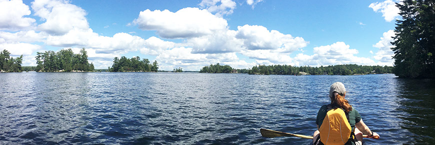
Paddling
Trent-Severn Waterway National Historic Site
Overview
Long before the modern Trent-Severn Waterway was constructed, Indigenous peoples used the land-river-lake route to paddle and travel through the Kawarthas and between Lake Huron and Lake Ontario. The first European to cross the same route was Samuel de Champlain in 1615.
The 386km-long navigation system we travel today was originally conceived for trade and military purposes. Now a National Historic Site, the Trent-Severn Waterway offers the perfect setting for recreational exploring and community-based tourism, while connecting visitors with that earlier time.
Many discoveries await those who travel here by canoe or kayak. Paddlers have more flexibility than others to experience the Waterway’s diverse landscapes, by slowing down and exploring each of the many lakes and rivers that form this immense system.
There are paddling adventures of any length to be had along the Trent-Severn Waterway, and as with any outdoor excursion, proper planning is required. This includes researching potential hazards, checking the weather forecasts before you go and always carrying safety equipment. Use this information below to plan your trip, and have safe and memorable visit to this special place.

Navigating the Trent-Severn Waterway
The Waterway encompasses 44 locks (2 lift locks, 1 marine railway, 2 flight locks, and 37 conventional locks), three original lockmaster houses, more than 130 dams to manage water levels, 40 swing bridges, and many kilometers of excavated canals. Creating a trip plan for yourself can seem overwhelming at first, but if you use this information below to better understand the Waterway, you will feel confident planning your own safe and memorable visit.
Go with the flow
Paddlers must be aware of the direction that the water flows when planning any trip. The best direction to paddle is with the flow of the water, not against it. The current of the rivers can be quite strong in certain places, making it more difficult to paddle. The summit of the Trent-Severn Waterway is Balsam Lake. To paddle with the flow of the water, it is best to paddle from Balsam Lake to Georgian Bay or from Balsam Lake to Lake Ontario.
If you wish to paddle the system in its entirety, it is best to start from Lake Ontario and finish in Georgian Bay for two reasons:
- Prevailing southwest winds blow in that general direction and there is nothing worse than tackling a large lake such as Lake Simcoe and paddling for miles into a stiff south wind
- Paddling across larger bodies of water like lakes, the current becomes less of a factor
Follow the buoys
Bouys are colourful floating navigational aids that indicate the boundaries of the navigational channel. They will guide you if you are not sure which direction to paddle. Learn more about navigational aidsMaps
There are two types of maps we suggest you consult on your paddling trip:
- Paper charts / Nautical charts can be purchased online at charts.gc.ca
- Topographic maps cover a wider area than the navigation charts (including: feeder lakes, rivers and streams along with highways and road access points) and can be downloaded from various sources online
Guides and other publications are available by mail from Parks Canada. Please contact us .
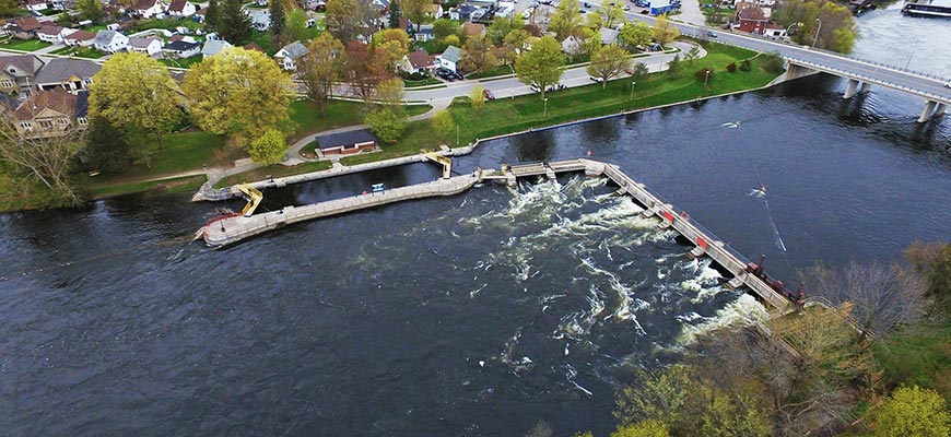
Lockage and lockstations
Lockage is the process of raising or lowering boats and paddlecraft from a lower or higher water elevation, into connecting sections of the Trent-Severn Waterway. Lockstations provide a base of operations for specially trained lockmsaters and their teams on-site, as well as various facilities and amenities available to visitors. In most locations, during seasonal Hours of Operation, paddlers can choose to portage around a lock, or travel through the lock with the purchase of a valid lockage permit.
Locking through
Locks along the Trent-Severn Waterway were constructed between 1833 and 1920 to overcome differences in water elevation in the creation of a navigable route. Lockage takes approximately 20 minutes to complete.
Lockage permits
A lockage permit is required for travel on the water through any of the lockstations on the Trent-Severn Waterway. Permits may be purchased upon arrival, or in advance online, or by phone. Special rates apply for canoes and kayaks.
Purchase your lockage permits in advance online, in person at lockstations, or by phone: 1-888-773-8888
Portaging
Many lockstations have a paddle dock or suitable shoreline for exiting your paddlecraft and carrying your vessel to the other side of the lockstation free of charge. Contact a lockstation in advance of your trip to ask about the availability of paddle docks and/or portage routes.
Lockstations
There are 42 locksations along the Trent-Severn Waterway National Historic Site. Basic on-site facilities at lockstations (such as washrooms and picnic tables) cater to the needs of paddlers, and various overnight stay options invite you to plan an extended visit.
Planning a trip
Length of your trip
You can plan a paddling trip on the Trent-Severn Waterway that lasts an afternoon, a weekend, or an entire summer. With the ability to camp at almost any lockstation, plus an array of other reserveable accommodations to choose from, it's easy to design an adventure that fits your schedule.
End to end
The time it takes to paddle all 387 kilometers of the Trent-Severn Waterway in one trip depends on the weather and skill level of the paddler. In general, you should set aside 25-30 days to paddle entire system (at around 15km/day). If you'd also like to paddle the many lakes and rivers shouldering the navigational channel, plan for an entire summer of tripping.
Best time to paddle
If you are seeking a quieter experience, the best times to paddle on the Trent-Severn Waterway are during the shoulder seasons (May, June, September and October) on account of:
- Fewer powerboats
- Moderate temperatures
- Best choice of campsites
During early spring, be aware of colder water temperatures, higher water levels and stronger currents.
Paddling during peak season
If you wish to paddle during the height of powerboat season (July and August), the trip can still be fantastic. Unlike powerboats, canoes and kayaks do not have to follow the channel. In fact, most paddlers prefer to follow the shoreline and take a less direct route from one lock to another, away from the noise and wake of powerboats, and closer to interesting sights on shore.
Paddling environments and conditions
A number of natural paddling environments – lakes, rivers and wetlands – showcase the beauty and diversity of the system. The beauty and variety of its scenery is one of the Waterway's greatest assets, where one will pass by lush farmland, marshes rich with wildlife, and a diverse range of geological landscapes.
Environments by region
When following the navigational channel, the Trent-Severn Waterway offers five different paddling environments: lakes (of various sizes and depths), marshes, open rivers, narrow channels, and populated rivers. Below is a description of what to expect on different sections along the waterway.
Trenton to Lakefield
Overview
Location: Lock 1 to Lock 26
Open rivers, lakes, and canals. Water flows from Lakefield to Trenton.
- Starts with the winding Trent River.
- Occasionally there will be openings so beware of winds
- Some bays and islands can be found
- Followed by Rice Lake
- Shallow lake that lies in rolling farmland
- Deeply indented shoreline
- Marshes extend into its waters
- There are 27 islands that rise like miniature mountains from its surface
- Then enter the Otonabee River, followed by:
- Little Lake (a small lake located in downtown Peterborough);
- The narrow Trent Canal at Lock 20;
- Then back on the Otonabee River at Trent University
Caution
- It can be difficult to escape winds on certain sections the Trent River
- Beware of powerboats in narrower and winding sections of the Trent River and Otonabee River
- Rice Lake can become quite rough with high winds
Good to know
- Manoomin (wild rice), a food source of great historical, spiritual, and cultural importance to Indigenous peoples grows on the shores on Rice Lake
- Great region for fishing
- There are several sections of urban paddling (Campbellford, Hastings, Peterborough, Lakefield) with chances to get out of the water and access towns or cities within walking distance.
Kawartha Lakes
Overview
Location: Lakefield to Balsam Lake
Beautiful, scenic lakes of various sizes with natural and populated shorelines. Short sections of canal as you enter and exit locks along the way.
Lakes in this region
Katchewanooka Lake
A long narrow lake with shallow shorelines with a deep, open channel travelling the lake from end to end
Clear Lake
A small spring-fed lake with clear and deep waters.
Stoney Lake
Encompasses over 1000 islands and shoals are everywhere.
Lovesick Lake
Located in the Land Between corridor, a transition zone of two overlapping geological and ecological zones: the limestone foundation of the St. Lawrence Lowlands to the south and the pre-Cambrian granite and Boreal forest of the Canadian Shield to the north.
Lower Buckhorn Lake
Numerous small islands and inlets are located within the lake while the southern area is dominated by open water, known as Deer Bay. Waters are not overly deep at any point in the lake.
Buckhorn Lake
Clear waters, rocky Canadian Shield shorelines speckled with many rocky islands and weed beds.
Pigeon Lake
Part of the largest body of water in the Kawarthas with access to six other lakes. The lake’s depth varies: the water is deepest in the north and most shallow and weedy in the southern portion.
Sturgeon Lake
A large lake with relatively shallow waters that lies within the narrow belt of limestone topography with rocky or sandy shorelines.Cameron lake
A smaller lake that lies within the narrow belt of limestone topography with somewhat shallow and rocky or sandy shorelines.
Balsam Lake
A larger lake with a Big Island in its center that lies within the narrow belt of limestone topography with somewhat shallow and rocky or sandy shorelines.
Caution
Strong winds on open lakes
Good to know
- Popular section of the system with many boaters and cottages
- Many bays and islands from Stoney lake to Buckhorn; an ideal atmosphere for paddling
- Great for swimming and fishing
Balsam Lake to Lake Simcoe
Overview
A mix of canals, marshy shorelines, flooded lakes and rivers. Water flows from Balsam Lake to Lake Simcoe
- Enter the narrow canal from Balsam Lake to Mitchell Lake (a smaller flooded lake with shallow waters and marshy shorelines)
- Then again from Mitchell Lake to Canal Lake (flooded lake with relatively shallow waters and some marshy shorelines)
- This is followed by the Talbot river and then straight down the Talbot canal passing through a set of locks before reaching Lake Simcoe (one of the largest lakes in Ontario with cleaner and warmer waters)
Caution
Strong winds on Balsam, Mitchell and Canal lakes.
Good to know
- Great swimming spots along the sandy shores of Balsam Lake or sand banks
- Ideal atmosphere for paddling
Lake Simcoe to Sparrow Lake
Overview
Large open lakes followed by:
- A narrow canal between Lake Couchiching (a medium-sized lake separated north of Lake Simcoe by a narrow channel with fairly shallow waters);
- and Sparrow Lake (a smaller lake with somewhat shallow waters spotted with granite islands and surrounded by rocky, well-treed shorelines)
Caution
Be aware of strong winds and boating traffic on Lake Simcoe and Lake Couchiching. Sudden storms are frequent. Every possible caution should be observed before heading out on these two lakes.
Good to know
- Lake Simcoe is lined with several beaches and great swimming spots
- The Narrows and the Mnjikaning Fish Weirs National Historic Site is located where Lake Simcoe and Lake Couchiching connect
- A popular and busy section for boaters; do not wander too far from the shore
Sparrow Lake to Port Severn
Overview
Winding Severn River lined with rocky shorelines of the Canadian Shield emptying into Georgian Bay. Mostly sheltered from strong winds and waves. Water flows from Sparrow Lake to Georgian Bay.
Caution
Openings where the wind can pick up suddenly.
Good to know
- Great for fishing and swimming
- Many islands and bays; an ideal atmosphere for paddling
Safety
A number of visitor guidelines are in place on the Trent-Severn Waterway to help ensure that visitors enjoy a safe and memorable paddling experience while Parks Canada continues to preserve and protect this special place. It is also good practice to notify a family member or friend of your plans and your trip itinerary in case of emergency.

Mandatory equipment
Bringing safety equipment is not only important for your personal safety, it is required by law. Ensure you have the appropriate safety gear for your vessel size and number of passengers onboard.
We recommend bringing these items onboard for your next paddling adventure:
- Lifejacket(s) for each paddler; wearing or within easy reach
- One extra paddle
- Bailing can
- Whistle or a horn for emergencies
- 15+ m of throw rope; preferably floating rope
- Watertight flashlight
Hazards
Navigational Warnings (NAVWARNs)
These statements issued by the Government of Canada provide warnings to paddlers about such things as: obstructions to the waterway, increased flows in certain regions, construction, or change to navigational aids. Check the warnings for the Trent-Severn Waterway
Dams and waste weirs
For your safety, stay away from any dams and waste weirs. For the most part, these hazards are located near lockstations and marked with either signs or orange and white booms.
Capsize potential
Be aware of capsize potential on the large lakes, particularly in extreme conditions such as thunderstorms and strong winds.
Boatwash or wake
Watch out for boatwash or wake, and be prepared to handle the oncoming waves either by turning into the wave or using a low brace to stabilize the boat.
Weather conditions
Always check weather forecasts before heading out and choose your route accordingly. During a multi-day excursion, think ahead and check with lock staff as to the conditions for the next leg of your journey. Know the wind direction (not always a prevailing wind) and how this will affect your craft (head, side, or tail wind).
Periods of high water (April to mid-June)
River flows/currents increase in strength and paddlers should be cautious.
Important Bulletins
Be sure to check our Important Bulletins page before heading out on your paddling trip. Here we post information on closures, water levels and other information that may affect your travels. We post similar bulletins on social media. Follow @TrentSevernNHS and @TSWBoaterInfo on Twitter and TrentSevernNHS on Facebook.
Camping and accommodations
Camping at lockstations
Paddlers are welcome to camp at most lockstations on the Trent-Severn Waterway for a small nightly fee. Reservations are not required, but space is allocated at the discretion of the Lockmaster on a first-come, first-served basis.
Learn more about camping at lockstations
Reservable tent camping
Reservable campsites are offered at Lock 8 Percy Reach and Lock 35 Rosedale
oTENTik
Upgrade your camping experience by reserving a one-of-a-kind Parks Canada oTENTik located at Lock 24 Douro and Lock 35 Rosedale and enjoy the rustic feeling of camping with the comfort of a covered shelter and bed.
More information about oTENTik sites on the Waterway
Rustic Cabin
Experience comfort, coziness and silence with an overnight stay in a rustic cabin at Lock 35 Rosedale
More information about the Rosedale Rustic Cabin
Ôasis
Spend the night under a natural canopy and fall asleep admiring the stars in a teardrop shaped pod. The first of its kind in Ontario, the Ôasis sites at Lock 9 Meyers and Lock 10 Hagues Reach offer a great opportunity to discover or rediscover the joys of camping at new heights.
More information about the Ôasis sites
Other options
- Ferris Provincial Park
- Wolf Island Provincial Park
- Balsam Lake Provincial Park
- Mara Provincial Park
- McRae Point Provincial Park
- Date modified :