
History
Sault Ste. Marie Canal National Historic Site
A historic waterway
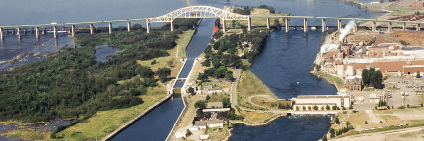
The Sault Ste. Marie Canal was constructed between 1889 and 1895 to bypass the turbulent rapids of the St. Marys River and to provide the last link in Canada's Great Lakes St. Lawrence shipping route.
With the retreat of the Wisconsin Glacier some 12,000 years ago, the St. Marys River ultimately carried Lake Superior waters east to Lake Huron. The St. Marys rapids result from a six-metre difference between the two lakes.
Indigenous use of the St. Mary's River rapids
Called Baawaating (place of the rapids) in Anishinaabemowin, the St. Marys River rapids and its plentiful resources attracted Indigenous peoples from around the Great Lakes and beyond. These rich waters have been an important part of the Anishinaabe way of life for millennia. The Anishinabek chose to live in this area for several strategic reasons, one of them being the abundance of fish all year long. It was once said that you could walk across the river on the backs of whitefish.
Learn more about Indigenous Culture.
The fur traders' canal
As they began to explore the rich fur lands of the Lake Superior area in the 17th century, European traders were hampered by the fierce rapids at Sault Ste. Marie. In 1797, the North West Company established a trading post on the north side of the rapids and in 1798 built a small lock. It was intended for the passage of bateaux and it facilitated the transfer of goods between the company's schooners on Lake Huron and Lake Superior. Destroyed in 1814, when the Americans attacked the company's nearby trading post, the canal was not rebuilt. The lock has been reconstructed on the original site, next to the St. Marys Paper administration building.
Canada hesitates

In the 1840s, when the great mineral potential of the Lake Superior area began to be developed, the Sault Ste. Marie Canal was reborn. Several proposals envisaged a canal large enough for lake vessels but Canadian enthusiasm dies in 1855 when the Americans completed a shipping canal on their side of the river. For the next four decades, all traffic between Lake Huron and Lake Superior passed through the American canal.
Canada's dependence on the American canal was not without conflict. In 1870, the Americans refused passage to Chicora, a vessel that had served as a blockade-runner in support of the South during the American Civil War. The Chicora was bound for the west with military supplies for the Red River Expedition. After weeks of diplomatic negotiating, the vessel was finally allowed passage on the condition that her military cargo be unloaded on the northern shore before passing through the American lock.
The "Chicora incident" raised concerns about the country's dependence on the Americans for access to Lake Superior. But the Canadian canal would not be built until it was clear that the flow of wheat and minerals from west of Lake Superior justified the cost.
Cast iron and cut stone
Construction began in 1889 and was completed in 1895, in very challenging conditions. The canal was cut through the bedrock of St. Marys Island. Red sandstone excavated from the cut was used for the construction of buildings on the site. When the lock opened in 1895, its chamber, 274 m long and 18 m wide, was the world's largest.
Stonecutters laboured for four years, using sandstone for the approach walls and limestone from the Windsor area and Manitoulin Island for the lock chamber. Foundries in Owen Sound, Welland, Toronto, and Montréal poured the cast-iron valves and lock gate machinery parts, and the four-year old Canadian General Electric Company supplied the generators, switches, wiring, and panels to power the machinery and illuminate the canal. On September 7, 1895, the lock was officially opened with the locking through of the Majestic, a new Canadian passenger steamer. Canada finally had an all-Canadian waterway from the Atlantic Ocean to the head of the Great Lakes.
The Sault Ste. Marie Canal joins Parks Canada
In 1979, the Sault Ste. Marie Canal was retired from the St. Lawrence Seaway management system and moved under the management of Parks Canada. The canal operated as a large shipping lock until 1987, when a significant crack in the south wall of the lock forced its indefinite closure. That same year, the canal was designated as a National Historic Site of Canada. For eleven years it remained nonoperational. In 1995, federal, provincial, and municipal governments agreed to each contribute resources in order to restore the lock. The restoration used a combination of modern and historic machinery to operate the lock gates and valves. In 1998, the canal reopened with a recreational lock, reduced in size from 274 metres to 77 metres long and operational for 5 months of the year.
Today, “locking through” in a recreational vessel, whether motor- or paddle-powered, is still a popular way to see the Sault Ste. Marie Canal. Visitors can also enjoy and explore the national historic site from dry land. North St. Mary’s Island retains its 20th-century park-like atmosphere with heritage flower gardens and historic trees planted during the early days of the canal. South St. Mary’s Island is returning to a more natural state, with local plants and wildlife thriving. A stroll along the Attikamek Trail will bring you face-to-face with nature during any season of the year.
Stop by the Visitor Centre, located in the historic Blacksmith’s Shop, to learn more about the site’s history.Related links
- Date modified :