Kejimkujik National Historic Site of Canada
Kejimkujik National Park of Canada, Nova Scotia
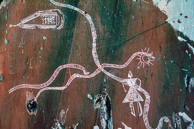
Detail view
© Parks Canada Agency / Agence Parcs Canada.
Address :
Kejimkujik National Park of Canada, Nova Scotia
Recognition Statute:
Historic Sites and Monuments Act (R.S.C., 1985, c. H-4)
Designation Date:
1994-11-24
Event, Person, Organization:
-
John Jeremy
(Person)
-
Mi'kmaq First Nation
(Builder)
Other Name(s):
-
Kejimkujik
(Designation Name)
-
Mi'kmaq Cultural Landscape at Kegimkujik / Le paysage culturel Mi'kmaq à Kejimkujik
(Plaque name)
Research Report Number:
1993-A01, 1994-036
DFRP Number:
02538 00
Plaque(s)
Existing plaque: Kejimkujik National Park of Canada, Nova Scotia
The cultural landscape at Kejimkujik attests to a Mi'kmaq presence in the area since time immemorial. The relationship between Mi'kmaq and their environment is evidenced in seasonal camps, burial grounds, fish weirs, hunting territories, portages and trails. In the 19th and 20th centuries, Mi'kmaq cleared homesteads around Kejimkujik Lake, worked in forestry and excelled as fishing and hunting guides. Petroglyphs, engraved on rock outcrops along the lakeshores, portray many aspects of Mi'kmaq life and spirituality, reflecting the strong bond between land and people.
Description of Historic Place
Kejimkujik National Historic Site of Canada is a protected area in the centre of the broader Mi’kmaq cultural landscape of Kespukwitk, one of the seven traditional districts of the Mi’kmaq. It encompasses 404 square kilometres of land and water in central south-western Nova Scotia’s Kejimkujik National Park of Canada. It is a cultural landscape associated with the Mi’kmaq people, and incorporates 38 aboriginal sites, four petroglyph sites, three villages and a cemetery. The designation refers to the site within the boundaries of the Kejimkujik National Park of Canada.
Heritage Value
Kejimkujik was designated a national historic site of Canada because: its cultural landscape attests to Mi’kmaq occupancy of this area since time immemorial, and includes petroglyph sites, habitation sites, fishing sites, hunting territories, travel routes and burials.
The heritage value of Kejimkujik lies in its broad range of cultural features, which serve as a testament to, and record of, the long-term relationship between the Mi’kmaq and the natural environment of their land.
Sources: Historic Sites and Monuments Board of Canada, Minutes, 1994; Commemorative Integrity Statement, 2000.
Character-Defining Elements
Key elements that contribute to the heritage character of the site include: the accessible location of Kejimkujik at the hub of a network of rivers between the Atlantic and Fundy coasts of southwestern Nova Scotia; the range of cultural features, including petroglyph sites, habitation sites, fishing sites, hunting territories, travel routes and burial sites, dating over millennia; the pre-contact habitation sites including three village sites - Merrymakedge, Eel Weir VI and Eel Weir X, nine sites associated with the two Eel Weir villages, eleven smaller sites, and seven isolated surface finds; the diversity of pre-contact site types, from villages to small resource camps; post-contact deposits on the above sites; physical evidence of early post-contact use on other sites, in particular, the evidence found on the trade axe site; surface and sub-surface remains on sites of twelve 19th-century Mi’kmaq reserves and in particular the homestead of John Jeremy; three petroglyph sites on the east shore of Kejimkujik Lake and one on the southern shore of George Lake; the over 450 Mi’kmaq images that have been recorded on these four sites including animals, canoes, people, sailing ships, churches, names and dates; the 1847 grave marker at the spiritual site of Merrymakedge Cemetery and all subsurface remains that are reminiscent of the 19th-century reserve communities and possibly earlier settlements on the lake; the portages around rough waters and trails connecting river systems; areas where plant species, game and/or fish are harvested within Kejimkujik, particularly those where evidence of the tribe still exists, such as the traces of three eel weirs in the lower Mersey river; the artefact collection, valuable due to the range of materials spanning an estimated 4000 years of occupation.