Claybank Brick Plant National Historic Site of Canada
Claybank, Saskatchewan
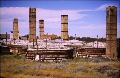
General view
© © Permission Guy Masson
Address :
Highway 339 / Claybank Brick Plant Road, Claybank, Saskatchewan
Recognition Statute:
Historic Sites and Monuments Act (R.S.C., 1985, c. H-4)
Designation Date:
1994-06-05
Dates:
-
1912 to 1937
(Construction)
-
1912 to 1937
(Significant)
Event, Person, Organization:
-
Dominion Fire Brick & Clay Products Limited
(Organization)
-
Richardson-Lovejoy Engineering Company (engineer)
(Architect)
Other Name(s):
-
Claybank Brick Plant
(Designation Name)
-
A. P. Green Refractories (Canada) Ltd.
(Other Name)
-
Saskatchewan Clay Products
(Other Name)
Research Report Number:
1994-016, 1994-AM-03
Plaque(s)
Existing plaque: Highway 339 / Claybank Brick Plant Road, Claybank, Saskatchewan
The Claybank brick plant is a remarkably intact example of an early 20th-century brickmaking complex. All the key structures erected during the site's development from 1912 to 1937 and much of the original brickmaking equipment survive. Using clay mined on site for most of its products, the plant became a major manufacturer of domestic clay firebrick and other refractory products for the railway, oil refining, power and metallurgical industries. The distinctive buff-coloured face brick that it also produced can be found on buildings across the Prairies and as far east as Québec.
Description of Historic Place
Claybank Brick Plant National Historic Site of Canada is a former industrial complex used for the manufacture of clay bricks from 1914 to 1989. It is located in a predominantly rural area of south-central Saskatchewan, along the Dirt Hills of the Missouri Coteau, near the communities of Claybank and Avonlea. The core of the 132-hectare site is a 37-hectare plant area containing buildings dating from the 1912-1937 period: a factory building, 10 kilns, a laboratory, an office building, a boiler room, stock sheds, a carpentry shop, residences, outhouses, and a bunkhouse. The site as a whole extends over a broad area encompassing internal road and path networks, the main approach to the plant, vestiges of industrial processes, the narrow-gauge rail line and a spur line that were used as part of an internal and external transportation system, and the clay pits in the Dirt Hills, from which clay was extracted for brick construction.
Heritage Value
The Claybank Brick Plant was designated a national historic site of Canada because: it is an extraordinarily intact example of an early 20th-century brick-making complex which retains all of the key structures and brick-making equipment of the 1912-1937 era; the plant was one of Canada's major producers of domestic clay refractory products used by the railways and the oil-refining, power and metallurgical industries using clay which was mined on-site; and because of the production of the distinctive face brick which was shipped for use in the construction of buildings across the prairies and beyond.
The heritage value of the Claybank Brick Plant lies in the relatively intact state of the physical resources from the late 1930s, including all of the key structures, equipment and industrial landscape elements from the 1912-1937 era. As such, it is representative of the way in which functional requirements and efficiency were primary drivers in the design and construction of industrial facilities. The plant, designed by Richardson-Lovejoy Engineering Company, was one of Canada's major producers of domestic clay refractory products, supplying fire-proof, heat-resistant, non-corrosive bricks for construction across the country, but especially in Western Canada. The complex is also an intact example of a self-contained manufacturing enterprise that used materials extracted on site.
Sources: Historic Sites and Monuments Board of Canada, Minutes, June 1994; Commemorative Integrity Statement, October 1998.
Character-Defining Elements
The key elements that relate to the heritage value of this site include: its siting and orientation in relation to the adjacent Dirt Hills; the plant area as evolved to the 1930s with its compact grouping of low-rise buildings with gable and flat roofs, 10 circular brick kilns and its functional layout with the kilns and stacks arranged in two rows between the factory buildings and the stock sheds; the main factory complex in its surviving massing, plan, and materials as a series of attached utilitarian buildings, including a clay storage shed, an engine room, tunnel dryers, hand mould shop, a factory and internal rail/transfer system in their found massing, layout and materials; the survival of buildings in their found massing, plan and materials which illustrate significant milestones in the plant's production history, including the laboratory, garage, office building, and the carpentry shop and oil room; the office building in its functional design as a one-storey block with a flat roof, simple symmetrically organized, rectangular openings, brick construction, the word ''OFFICE'' inscribed in brick above the main entrance; residences and outbuildings for managers and staff which survive in their found massing, plan and materials and include the southwest cottage, five outhouses, the Goodman cottage, Brick Cottage, and Oakley House; the bunkhouse in its simple, utilitarian design, brick construction, and location close to the plant area; the 10 kilns in their circular, domed massing, brick construction, large scale (to accommodate a capacity of 75,000 bricks), the interweaving of 5 stacks, with surviving machinery and equipment within and around the kilns; structures surviving in their found massing, plan and materials that were erected for the finishing and warehousing of materials prior to shipment, including the west stock shed, the east stock shed and the grinding room; in-situ equipment dating from the 1912-1937 period, including the clay grinder, conveyors and elevators, dry pans, a brick press, dryer and kiln equipment, portable narrow gauge rail line and associated rolling stock, core sample machines, mule wagon, gasoline sleigh, line shafts and belt drive system, tools, and engines; remains of industrial processes, including coal piles, the drainage ditch, the narrow-gauge rail line and its associated earthen works, the east and west ponds, and the northwest and southeast clay pits; transportation remains, including the trail leading from the Dirt Hills to Moose Jaw that passes through the site, the old road from the site to Claybank adjacent to the rail spur line to the plant, brick paths and paving within the plant area that pre-date 1937, and the road and culvert for the west residence in their routes, extent and found materials, internal rail lines in their routes, extent and surviving materials, including a narrow-gauge rail line and a spur line used to transport raw clay and finished bricks on site; evidence of gardens and landscaping from the 1930s and earlier; in-situ archaeological features associated with site use and occupancy, and the brick-making and clay-extraction processes in the 1912-37 period, including the barn north of the west pond, various outhouses, the dynamite shed, the northwest ad mid-west cottages, the original office south of the east pond, the south light tower, and sand house and house east of the east stock shed, as well as an extensive underground drainage system throughout the plant complex.