Obadjiwan–Fort Témiscamingue National Historic Site of Canada
Duhamel-Ouest, Quebec
Obadjiwan—Fort Témiscamingue
© Parks Canada | Parcs Canada
Address :
834 Chemin du Vieux Fort, Duhamel-Ouest, Quebec
Recognition Statute:
Historic Sites and Monuments Act (R.S.C., 1985, c. H-4)
Designation Date:
1931-05-28
Dates:
-
1685 to 1685
(Construction)
Event, Person, Organization:
-
Aeneas Cameron
(Person)
-
North West Company
(Organization)
Other Name(s):
-
Obadjiwan–Fort Témiscamingue
(Designation Name)
-
Fort-Témiscamingue
(Other Name)
-
Fort Temiscamingue
(Other Name)
-
Fort Témiscamingue
(Other Name)
-
Fort-Témiscamingue (Obadjiwan)
(Other Name)
Research Report Number:
1966-057, 1967-002; 1963-014; 2018-25
DFRP Number:
56458 00
Plaque(s)
Existing plaque: 840 Old Fort Road, Ville-Marie, Quebec
The first fort on this lake was built by the government of New France about 1685 to compete with the English on Hudson Bay. Closed in the 1690s Fort Temiscamingue was re-established in 1720 and leased to merchants until the fall of New France. After the Conquest various free traders settled on the lake, but the North West Company had a virtual monopoly by the 1790s, thanks to the astute management of Aeneas Cameron. Control of the fort remained with the Cameron family for many years after the union of the Hudson's Bay and North West Companies in 1821.
*Note: This designation has been identified for review. A review can be triggered for one of the following reasons - outdated language or terminology, absence of a significant layer of history, factual errors, controversial beliefs and behaviour, or significant new knowledge.
Description of Historic Place
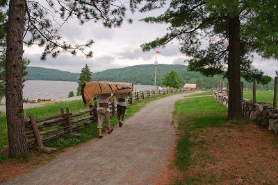
Obadjiwan—Fort Témiscamingue National Historic Site of Canada is situated on the east shore of Lake Timiskaming near Ville Marie, south western Quebec. Long used by First Nations peoples, the area saw European settlement after a French fur trading post was established. Only vestiges remain from the cluster of buildings that served the Ottawa River fur trade route from 1685-1902. The site, overlooking the lake, features modern interpretive buildings, archaeological resources and reconstructed components. Grass, paths and trees slope down to the shoreline. Official recognition refers to the area encompassed by the original site of Fort Témiscamingue (containing the remains of the trading post and associated activities).
Heritage Value
Obadjiwan—Fort Témiscamingue was designated a National Historic Site of Canada in 1931. It is recognized because:
by at least 6,500 years ago in the Archaic period, and throughout the following Woodland periods (3,000 years ago to 1600 Common Era), this place was settled by a succession of peoples whose way of life was seasonally mobile and reliant on the resources of the northern boreal forest. Their campsites are found throughout the surrounding region. Archaeological artifacts such as tools made of non-local stone, early ceramics, copper, and even corn kernels reflect the vast exchange networks that connected them at different times to other Indigenous cultures ranging from west of Lake Superior, James Bay, Lac St. Jean, southern Ontario, and beyond. These networks were integral to the success of mobile societies by connecting families, and maintaining the flow of information and material objects; the first trade post on this lake was built by the government of New France about 1685 at the mouth of the Montreal River to compete with the English on Hudson Bay. Closed in the 1690s, the post was re-established here in 1720 and leased to merchants until the fall of New France. Thereafter, various free traders settled on Lake Timiskaming, but by the 1790s a monopoly was held by North West Company, and after 1821 by Hudson’s Bay Company; it is representative of northern boreal trade posts whose operations relied on the skills and support of Algonquin trappers, matriarchs, and their families; as early as the 1830s, the Timiskaming First Nation supported a succession of missionaries at the post and the establishment in 1863 of the Saint-Claude Oblate mission on the west side of the narrows. Prompted by the mission, the following year Timiskaming First Nation members began farming on lands around the post and along the shores of the lake; in the 19th century, it was where the Timiskaming First Nation held the traditional elections of Chiefs.
Obadjiwan—Fort Témiscamingue National Historic Site of Canada retains evidence of use by First Nations hunter-gatherer-fisher peoples over thousands of years, and was important to fur trade commerce between Europeans and Algonquians for nearly two centuries. The site speaks to French-British rivalry over the region`s fur supply during the 17th and 18th centuries and the exploitation of this resource by independent traders and fur trade monopolies. After the French Régime fell, independent merchants established posts around the lake from 1763-1795. Aeneas Cameron managed the fort from 1793, and was retained when the North West Company purchased the post in 1795. The fort and store came under the control of the Hudson's Bay Company (HBC) in 1821 when the two trade companies merged. It was, for almost half a century, the headquarters of the Swan River District of the HBC until its closure in 1902. The shoreline water level changed after construction of a hydroelectric dam on the Ottawa River in 1919. When the fort was sold in 1921 all buildings were removed. The site is jointly managed by Parks Canada and the Timiskaming First Nation.
Sources: Historic Sites and Monuments Board of Canada, Minutes, 1931, June 1967, 2018.
Character-Defining Elements
Key elements contributing to the heritage value of this site include: the site’s strategic location on Lake Timiskaming on a point of land at the narrows; its promontory setting and natural topography comprising three distinct landscape areas: a plateau bordered by forest, a lower plateau that was the trade post site, and the beach (that surrounded the point before construction of the 1919 dam); traces of buildings and pre-1902 structures including foundations, chimneys and fireplaces; the Hudson Bay Co. cemetery; the two respective Mission cemeteries, and any grave markers; artifacts relating to trade activity both discovered, and undiscovered, including those removed and stored in Parks Canada collections, artifacts at the Gare Maritime Champlain Québec, and those used for on-site interpretation; traces of Témiscamingue Anishinabe presence during and pre-dating the historic era, and knowledge associated with First Nations artifacts removed from site; the historic access road, the spatial and visual inter-relationship between site components, the open landscape character, and viewscapes to Lake Timiskaming and across the narrows to the Saint-Claude Mission site.