Fort Lennox National Historic Site of Canada
Saint-Paul-de-l'Île-aux-Noix, Quebec
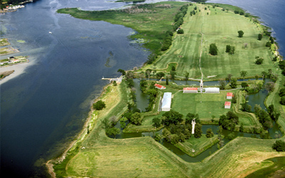
Position as an island in the Richelieu River
© Parks Canada Agency / Agence Parcs Canada.
Address :
1 61st Avenue, Saint-Paul-de-l'Île-aux-Noix, Quebec
Recognition Statute:
Historic Sites and Monuments Act (R.S.C., 1985, c. H-4)
Designation Date:
1920-01-30
Dates:
-
1759 to 1760
(Construction)
-
1775 to 1778
(Significant)
-
1812 to 1814
(Significant)
Event, Person, Organization:
-
War of 1812
(Event)
-
Fenian Raids
(Event)
-
American Revolutionary War
(Event)
Other Name(s):
-
Fort Lennox
(Designation Name)
DFRP Number:
06669 00
Plaque(s)
Original Plaque: Front gates, Fort Lennox, Quebec
A gateway to Canada and advance post against Iroquois and other invaders. Island fortified by the French before 1759, additional works by the Americans in 1775. The whole place rebuilt by the Imperial authorities during the period from 1812 to 1827.
Existing plaque: 1 61st Avenue, Saint-Paul-de-l'Île-aux-Noix, Quebec
Fort Lennox was the third fortification built on Isle-aux-Noix as a barrier to invasion along the Richelieu River from the south. The island was first fortified by the French in 1759 but the British captured it the next year. In 1775 the Americans occupied the island as a base for their attack on Canada. After they retreated the British erected a new fort to deter further American invasion. During the War of 1812 it protected an important naval base. Later this fort was razed and a new masonry work, Fort Lennox, was built (1819-29) to guard the Canadian border. It was garrisoned until 1870.
Description of Historic Place
Fort Lennox National Historic Site of Canada is a highly evocative military fortification and landscape covering the full extent of Île aux Noix in the Richelieu River near the city of Saint-Paul-de-l’Île-aux-Noix, Québec. Over a critical period from the end of the French Regime to the 1870s, French, American and British forces exploited the strategic value of the site. The fortifications themselves are framed by a water-filled moat that surrounds the ramparts. Inside is a collection of handsome, classically designed buildings beautifully executed in stone. The designation refers to the entire historic place and the cultural resources it contains.
Heritage Value
Fort Lennox was designated a national historic site of Canada in 1920 because: in preventing invasions via the Richelieu River, one of the gateways to Canada, it was repeatedly fortified from 1759 onwards and was occupied by a garrison until 1870.
Fort Lennox played an important role in the military history of Canada due to its strategic location along the Hudson-Champlain-Richelieu navigation route. The island’s geography, with narrow channels and an elevated southern point, provided a natural defence system that was supplemented by military defensive works. The French first fortified the island in 1759 as a barrier to British invasion along the Richelieu River. In 1760, the British captured the island, just prior to the fall of New France. In 1775, American revolutionary forces used the island as a base for an attack on Canada. After their retreat in 1776, the British began fortifying the island to guard against further invasions. During the War of 1812 the fort was used to secure the border with the United States and to protect the Royal Navy base at Saint-Jean. The present Fort Lennox, the third set of fortifications on the island, was built from 1819 to 1828. It replaced the earlier fort and was garrisoned until 1870. Île aux Noix was also used, but not modified, by British forces during the uprising of the Patriots, the Fenian Raids, and the American Civil War. After the departure of the British garrison in 1870, the Canadian militia used the site for summer training until 1921. From 1940 to 1943 a refugee camp for European Jews was located on the island.
The historic place includes archaeological and built resources associated with each of the following periods of military occupation: the French fortifications (1759-1760); the period of American occupation (1775-1776); the first British occupation and installations (before 1778); the first British fortifications (1778-1812); the redevelopment of the British fortifications (1812-1819); the naval establishment (1812-1834); and the establishment and operation of Fort Lennox (1819 to present times).
Sources: Historic Sites and Monuments Board of Canada, Minutes, 1920; Commemorative Integrity Statement, August 2002.
Character-Defining Elements
Key elements that contribute to the heritage value of this site include: its position as an island in the Richelieu River, the main point of entry between Canada and the American colonies in the 18th century; its natural geography, consisting of a long narrow island with deep channels on either side; those elements which speak to the site as a fortification; the built features consisting of the fort itself, its walls, ramparts, entrance ports and gates; the buildings, their stone construction, their volume, mass, roof type, window and door placements, openings, surviving interior fittings in their surviving original locations, massing and materials; those landscape features which speak to a military purpose, namely the open central parade ground, the placement of the buildings and built features within the interior of the fort; the surrounding moat and glacis, the trenches, roads, the open, free fire zone, the related cemeteries, the uninterrupted views towards the river, and the field to the north in their surviving original morphology and materials; objects and archaeological sites related to the site’s military history in their found locations, extent and materials.