Battle of the Châteauguay National Historic Site of Canada
Très-Saint-Sacrement, Quebec
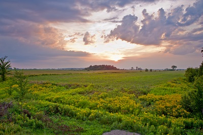
Front line of the battlefield
© Parks Canada | Parcs Canada
Address :
2371 chemin de la rivière Châteauguay, Très-Saint-Sacrement, Quebec
Recognition Statute:
Historic Sites and Monuments Act (R.S.C., 1985, c. H-4)
Designation Date:
1920-01-30
Dates:
-
1813 to 1813
(Significant)
Other Name(s):
-
Battle of the Châteauguay
(Designation Name)
Research Report Number:
1965-004, 1963-015, 1962-037, 1998-035
DFRP Number:
07319 00
Plaque(s)
Existing plaque: 2371 chemin de la rivière Châteauguay, Très-Saint-Sacrement, Quebec
Here, on 26 October 1813 a Canadian force of about 300 consisting of Voltigeurs, Canadian Fencibles, Sedentary and Select Embodied Militia and Indians, commanded by Lieutenant Colonel Charles Michel de Salaberry, halted 5,700 American troops led by Major General Wade Hampton. In turning back the American advance on Montréal de Salaberry and his militiamen thwarted the most ambitious enemy invasion of the War of 1812 and saved the province.
*Note: This designation has been identified for review. A review can be triggered for one of the following reasons - outdated language or terminology, absence of a significant layer of history, factual errors, controversial beliefs and behaviour, or significant new knowledge.
Description of Historic Place
Battle of the Châteauguay National Historic Site of Canada is a small fragment of a War of 1812 battlefield located on the banks of the Châteauguay River at Allan's Corners in the municipality of Howick, near Ormstown, some 50 kilometres south-west of Montréal.
Heritage Value
Battle of the Châteauguay was declared a national historic site because it was the site of a Canadian victory on 26 October 1813, and because of the role French Canadian troops played in the defence of Canada against American invasion during the War of 1812.
The heritage value of Battle of the Châteauguay National Historic Site resides in its identity as a memorial remnant in the midst of the legible, relatively undisturbed cultural landscape of the battlefield which extends from the fork of the Châteauguay and Outardes Rivers to that of the Châteauguay and English, covering an area of about 500 acres. The centre of the battlefield was located between Morrison Ford and Round Point.
Source: HSMBC Minute, 1977 and 1997; Commemorative Integrity Statement
Character-Defining Elements
Aspects of this site which contribute to its heritage values include: the landscape as tangible link with the historic battlefield, the viewscapes between the battlefield and the river, the numerous small streams flowing into the Chateauguay River used by de Salaberry as defensive positions, the trace of the wagon trail used by the American soldiers, archaeological remains related to the battle (the blinds, the blockhouse, the trenches, ford defences, and logistical installations), the commemorative monument and plaque erected by the Canadian government in 1895.