Battle of Stoney Creek National Historic Site of Canada
Stoney Creek, Ontario
General view
(© Parks Canada Agency / Agence Parcs Canada)
Address :
77 King Street West, Stoney Creek, Ontario
Recognition Statute:
Historic Sites and Monuments Act (R.S.C., 1985, c. H-4)
Designation Date:
1960-05-30
Dates:
-
1813 to 1813
(Significant)
Event, Person, Organization:
-
Battle of Stoney Creek
(Event)
-
General John Chandler
(Person)
-
General Windler
(Person)
-
Lieutenant Colonel John Harvey
(Person)
-
Major Plenderleath
(Person)
-
8th Regiment of the British Army
(Organization)
-
49th Regiment of the British Army
(Organization)
-
Women's Wentworth County Historical Society
(Organization)
-
County of Wentworth Veteran's Association
(Organization)
-
Niagara Parks Commission
(Organization)
-
Dunnington and Grubb
(Architect)
Other Name(s):
-
Battle of Stoney Creek
(Designation Name)
Research Report Number:
1960-021, 1992-OB-07 Nov, 2010-SDC-CED-035
Plaque(s)
Existing plaque: 77 King Street West, Stoney Creek, Ontario
During 1813 the Americans planned to invade Upper Canada from Detroit and the Niagara Peninsula. In late May, an American force crossed the Niagara River, seized Fort George, and with about 3500 troops moved inland in pursuit of the British who retreated to Burlington Heights. At Stoney Creek, a surprise night attack by about 700 regulars of the 8th and 49th Regiments of Foot under Lt.-Col. John Harvey halted the American advance and allowed the British to re-establish their position on the Niagara frontier. The Americans retreated to Forty Mile Creek and subsequently to Fort George.
Description of Historic Place
Battle of Stoney Creek National Historic Site of Canada is a memorial park built on the site of a battlefield from the War of 1812. It is located at the edge of the Niagara escarpment on the east side of the town of Stoney Creek, Ontario. The site includes the Gage House, the Stoney Creek, Smith’s Knoll and the Stoney Creek Cemetery Monument, the Dunnington-Grubb and Stoney Creek Cemetery landscape; archaeological resources; and objects held in repositories and on the site. Official recognition refers to the Battlefield Park and Smiths Knoll cemetery which encompasses the Stoney Creek Memorial, the cemetery and Gage House.
Heritage Value
The Battle of Stoney Creek was designated a national historic site of Canada in 1960, because of: the undoubted national importance of the military engagement that took place there.
The heritage value of this site resides in its role as a critical battle in Canadian history as illustrated by the memorial park, its battle memorials and associated cemetery. The Battle of Stoney Creek, which occurred on 6 June 1813, was a critical turning point in the War of 1812. During this battle, American forces under Generals Windler and John Chandler were driven back by the British 8th and 49th Regiments led by Lieutenant Colonel John Harvey and Major Plenderleath. This battlefield marks the most advanced position achieved by American forces on the Niagara frontier.
The importance of Stoney Creek Battlefield was first acknowledged when the Women’s Wentworth County Historical Society opened a commemorative park on the battlefield site in 1899, and shortly thereafter acquired the adjacent Gage property, which was also associated with the battle. Between 1909 and 1913, the County of Wentworth Veteran’s Association erected a monument and in the 1920s, the firm of Dunnington and Grubb formally landscaped the park’s grounds. Management of the park was taken over by the Niagara Parks Commission in 1963 and today is run by the City of Hamilton.
Sources: Historic Sites and Monuments Board of Canada, Minutes, 1960; Commemorative Integrity Statement, August 2002.
Character-Defining Elements
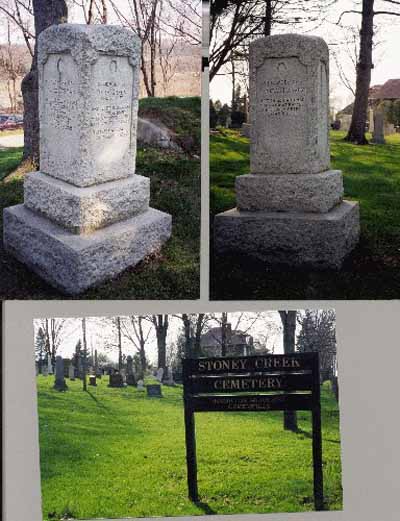
Key elements that contribute to the heritage value of this site include: its locations associated with the battle of Stoney Creek, including the battlefield, the Stoney Creek Cemetery, the Gage House, and Smith’s Knoll; the geographic features relevant to the battle, including the ridge at Smith’s Knoll, Battlefield Creek, and the open area in front of the Gage House; the developed memorial landscape with its rolling lawns, creek, knoll, three monuments, and the Gage; the Gage House in its location and two-storey rectangular massing, its log and timber construction on a stone foundation, its wood cladding, its symmetrical 5-bay façade, its classically inspired detailing including the central, side-lit doorway, front verandah, and surviving evidence of interior layout and materials dating from 1813; the Stoney Creek Monument in its symbolic design based on the Nelson monument in Edinburgh , consisting of a square base topped by a tapering octagonal tower with Tudor Gothic Revival style detailing (crenellation, coping, corbels, shield motifs, heavy oak doorway, turrets, buttresses), its symbolic construction of all-Canadian materials using Georgetown, Hamilton and Queenstown limestone and a reinforced concrete core, its interior spiral staircase staged with broad landings; its designed setting with tree-lined paths, flower beds and a flight of steps leading from the Gage House to the monument; its siting high on a terrace with views across the battlefield from the tower windows; the Smith’s Knoll Monument with its 4 meter-high truncated pyramid constructed of fieldstone, capped with a limestone slab which supports a carved sandstone lion, the plaques affixed to the base, and the crypt; its setting on the knoll within a fieldstone wall; its location on a site critical to the battle; the Stoney Creek Cemetery Monument with its two meter-high square granite pillar composed of three square stones of diminishing size, its inscriptions, and the location of the monument in a pre-existing cemetery on the site of initial battle contact; the Dunnington-Grubb landscape with its linear avenue between Gage House and the Stoney Creek Monument flanked by Scots pines and set in a ring of lawns surrounded by a hedge and circular avenue, particularly as reflected in surviving original plantings, materials, and layout;
- the Stoney Creek Cemetery with its footprint, location, and land forms as witness to the battle, and its monument to the fallen British officer Harvey; the integrity of any surviving or as yet not identified archaeological remnants which may be found within the site in their original placement and extent, including remnants of the Battle of Stoney Creek vestiges of life at the time of the battle, and vestiges associated with the commemoration of the Battle of Stoney Creek; the movable resources held on site, including the original Dunnington-Grubb landscape plan, remnants of the original iron gate at Smith’s Knoll, the trowel used in the placement of the cornerstone of the Stoney Creek Monument, military equipment used at the battle, the cannons at the Stoney Creek Monument and at Smith’s Knoll; viewscapes between Gage House and Battlefield Monument, between the battle sites and the commemorative sites, along the Niagara Escarpment, and along the path of King St. from the battlefield property.