Whitefish Island National Historic Site of Canada
Sault Ste. Marie, Ontario
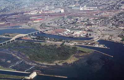
Aerial view
© Agence Parcs Canada / Parks Canada Agency, G. Vandervlugt, 2001.
Address :
Sault Ste. Marie, Ontario
Recognition Statute:
Historic Sites and Monuments Act (R.S.C., 1985, c. H-4)
Designation Date:
1981-11-13
Event, Person, Organization:
Other Name(s):
-
Whitefish Island
(Designation Name)
Research Report Number:
1981-SUB
Plaque(s)
Existing plaque: Whitefish Island, Sault Ste. Marie, Ontario
Whitefish Island has been the site of native encampments since it was formed over 2000 years ago by geological processes. From the time that pottery was first used by native groups around 300 B.C., eight successive cultures have occupied the site, culminating in the development of the Ojibway nation in the Sault Ste Marie area. The island's unique location between Lakes Huron and Superior, and the rich fisheries of the St. Mary's Rapids, made it a focal point of prehistoric and historic trade and settlement until early in the 20th century.
Description of Historic Place
Whitefish Island National Historic Site of Canada is located on the Canadian side of St. Mary’s River in Sault Ste. Marie, Ontario. Formed more than 2000 years ago, Whitefish Island was an Aboriginal settlement, trading post and fishing base. The island is a low-lying, tear-shaped boulder field 1 kilometre long, and up to 500 metres wide that has accumulated up to 50 centimetres of soil, primarily from centuries of human occupation. The high organic content of the soil supports dense brush that covers most of the landscape. The island is positioned on the southern edge of the Sault Ste. Marie Canal National Historic Site of Canada and is undeveloped and intact both as an archaeological site and as a geographic feature. Official recognition refers to the island with its traces of Aboriginal and European activity.
Heritage Value
Whitefish Island was designated a national historic site of Canada because: of its pre-contact remains; since its formation, the island was the site of Aboriginal encampments; its unique location made it a focal point of pre-contact trade and settlement. (SOCI)
Whitefish Island has been the site of native encampments since it was formed over 2000 years ago by geological processes. From the time that pottery was first used by native peoples around 300 B.C., eight successive cultures have occupied the site, culminating in the development of the Ojibwa nation in the Sault Ste. Marie area. The island’s unique location between Lakes Huron and Superior, and the rich fisheries of the turbulent St. Mary’s rapids, made it a focal point of prehistoric and historic trade and settlement until early in the 20th century. The island represents not only the evolution of Ojibwa culture centred on the fishery, but also the influences of other Great Lake cultures through trade and visits. Even though it was surrounded by industrial and urban development, Whitefish Island remained undisturbed.
Source: Historic Sites and Monuments Board of Canada, Minutes, November 1981.
Character-Defining Elements
Key elements that contribute to the heritage value of this site include: its location on the southern edge of the north bank of the St. Mary’s River, beside the St. Mary’s Rapids; the island’s composition, consisting of a low-lying, tear shaped boulder field 1 kilometre long and 500 metres wide; the open nature of the island’s landscape and its cover of dense brush; the integrity of any surviving or as yet unidentified archaeological remains dating from approximately 2000 years ago until the late 19th century, which may be found within the site in their original placement and extent; the relationship of Whitefish Island to the surrounding historic setting that includes the Sault Ste. Marie Canal, the St. Mary’s Rapids, the road and rail bridges, the American locks complex, the Power Canal and Generating River below the lock, the buildings, the engineering works and associated landscape; viewscapes from the island to the river rapids.