Fort Wellington National Historic Site of Canada
Prescott, Ontario
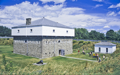
General view
© Parks Canada Agency / Agence Parcs Canada, Brian Morin, 2006.
Address :
King Street, Prescott, Ontario
Recognition Statute:
Historic Sites and Monuments Act (R.S.C., 1985, c. H-4)
Designation Date:
1920-01-30
Dates:
-
1813 to 1814
(Construction)
-
1813 to 1813
(Significant)
-
1838 to 1838
(Significant)
Event, Person, Organization:
-
War of 1812
(Event)
-
1838 American border raids
(Event)
-
Lieutenant Colonel Thomas Pearson
(Person)
-
Lieutenant Colonel George R.J. Macdonnell
(Person)
Other Name(s):
-
Fort Wellington
(Designation Name)
Research Report Number:
1997-034
DFRP Number:
56476 00
Plaque(s)
Original Plaque: inside the Blockhouse - third floor King Street East, Prescott, Ontario
CONSTRUCTED IN 1812 AND 1813 UNDER DIRECTION OF LIEUTENANT COLONELS THOMAS PEARSON AND GEORGE R.J. MACDONELL AS THE MAIN POST FOR THE DEFENCE OF THE COMMUNICATION BETWEEN KINGSTON AND MONTREAL, AND NAMED FORT WELLINGTON, IN HONOR OF THE VICTORY GAINED AT SALAMANCA, 22ND JULY, 1812.
HERE LIEUTENANT COLONEL G.R.J. MACDONELL ASSEMBLED THE FORCE THAT TOOK OGDENSBURG, 22ND FEBRUARY, 1813.
HERE ALSO LIEUTENANT COLONEL PLOMER YOUNG ASSEMBLED THE TROOPS ENGAGED IN REPELLING THE INVASION AT THE WINDMILL, 11TH-13TH NOVEMBER 1856.
Existing plaque: at the entrance to old blockhouse King Street East Highway 2, Prescott, Ontario
The first Fort Wellington was erected on this site during the War of 1812 to shelter British regular troops and Canadian militia defending the vital St. Lawrence River transportation route. In February 1813 those soldiers crossed the ice to capture Ogdensburg, N. Y. When rebellion threatened Upper Canada in 1838 the fort was in ruins. Construction had scarcely begun on the present fort in November 1838 when a band of Canadian rebels and American sympathizers attached, they were defeated nearby at the Battle of the Windmill by troops assembled at this fort.
Description of Historic Place
Fort Wellington National Historic Site of Canada is one of the best preserved nineteenth-century fortifications in Canada. The current structure dates from 1838 and is built on the site of an earlier fort on the banks of the St. Lawrence River at Prescott, Ontario. Set on a rise, a blockhouse and officers’ quarters overlook the river.
Heritage Value
Fort Wellington was designated a national historic site because of its association with the protection of a vital transshipment point along the St. Lawrence River transportation route beginning in the War of 1812, the attack and capture of Ogdensburg, N.Y. by the troops based at Prescott in February 1813, the successful counter attack of loyalist forces against the “Hunters” at Windmill Point in November 1838.
The heritage value of Fort Wellington National Historic Site of Canada lies in the legibility of its found cultural landscape as an early 19th-century fortress, and in the integrity of surviving 1813-1838 remnants of that landscape as illustrations of its historic role.
Lieutenant Colonels Thomas Pearson and George R.J. Macdonnell built Fort Wellington in 1813-1814. This was an important fort during the War of 1812, and it was subsequently improved to play a more limited role in later American raids, most notably those following the 1837 Rebellion. Used up to the late 19th century as a militia base, it became a national historic site in 1925 and has since been restored for visitation. Extensive sections of the military lands associated with the fort have been alienated for development. In the 1980s Parks Canada acquired lands between the fort and the shore that had been extensively redeveloped for railway use (1855-1980).
Sources: Historic Sites and Monuments Board of Canada, Minutes, 1926, 1981; Commemorative Integrity Statement, 1998.
Character-Defining Elements
Key features contributing to the heritage value of this site include: the legibility of the cultural landscape of Fort Wellington as a defence work as reflected in its location, siting, the profile and footprint of its built features, its open ground, the spatial, functional and material inter-relationships of the buildings to one another and to surviving archaeological remains, fortifications and natural landscape features, location facing the American shore, on an elevated site on the river front, the open ground that surrounds it, unobstructed viewplanes across the St. Lawrence River, and to the town of Prescott,
Fortifications design of footprint and profile with the fortification on elevated ground surrounded by a sloping glacis, ditch and escarp, palisade, fraising, and gateway entrance, the trace of the earthen redoubt, remnants of the casemate on its inner face, evolved elements including the traverses and the caponniere, the spatial relationships of components of the fortifications including buildings, archaeological remnants and natural landscape features,
The blockhouse its square tower-like massing, design as three sections including a squat lower storey, an overhanging upper storey, and a pyramidal roof, its symmetrical organization with a central door and regular window openings, articulation as a defensive structure with few door and window openings and regularly spaced gun slits, surviving original fireproof materials including rubblestone foundation, masonry walls, brick magazine, its original wooden sub-structure, original surviving interior components including finishing and fitting details, window openings, doors with their frames, and hinges, original functional interior design into special purpose areas including well, armoury, guard room, barracks, siting as a fort within a fort oriented towards the river,
The officers’ quarters its rectangular massing under low hipped roof, its surviving 19th-century footprint, regular placement of original apertures, original surviving clapboard and shingles,
The latrine rectangular single-storey massing with hipped roof, its surviving 19th-century footprint and fabric including clapboarding and shingles,
Remains footprints and materials of archaeological remnants from the 1812-1814 period, 1828-1842 period, their spatial, functional and material inter-relationships to each other and to surviving built and landscape features.