Kingston Navy Yard National Historic Site of Canada
Kingston, Ontario
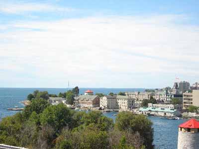
Showing Navy Bay and the 3-storey stone frigate
(© Parks Canada Agency / Agence Parcs Canada, 2008.)
Address :
Royal Military College of Canada / Collège militaire royal du Canada, Kingston, Ontario
Recognition Statute:
Historic Sites and Monuments Act (R.S.C., 1985, c. H-4)
Designation Date:
1928-05-16
Dates:
-
1789 to 1853
(Construction)
-
1813 to 1814
(Significant)
-
1819 to 1819
(Significant)
-
1838 to 1838
(Significant)
Event, Person, Organization:
-
War of 1812
(Event)
-
Archibald Fraser
(Person)
-
Provincial Marine
(Organization)
-
Royal Navy
(Organization)
-
Royal Engineers
(Architect)
Other Name(s):
-
Kingston Navy Yard
(Designation Name)
-
Royal Military College of Canada
(Other Name)
Research Report Number:
2005-SDC/CED-042
Plaque(s)
Existing plaque: On a stand in front of Old Stone Frigate building on grounds of Royal Military College Royal Military College, Kingston, Ontario
The Navy Yard established in 1789 as a trans-shipment point for the Great Lakes and as the Provincial Marine's Lake Ontario base was administered by the Admiralty after 1813. During the War of 1812 Commodore James Yeo, R. N., commanded a considerable squadron built in these yards, including the 112-gun St. LAWRENCE. This base posed a constant threat to the Americans, who never felt strong enough to risk a direct attack. The Rush-Bagot agreement of 1817, which limited armaments on the lakes, brought about a decline in activity, and by mid-centruy the yards were closed.
Description of Historic Place
The Kingston Navy Yard National Historic Site of Canada is located on Point Frederick, Kingston, in Ontario. It is a 37-hectare point of land at the confluence of the Cataraqui and St. Lawrence Rivers. The Navy Yard, a former dockyard and naval station occupied most of the peninsula that now contains the buildings of the Royal Military College of Canada complex. Official recognition refers to the surviving structures associated with the Navy Yard including the former naval surgeon’s quarters and dispensary now known as the Commandant’s House (1813-14), the stone wall that forms the western entrance to the inner enclosure or core of the RMC campus dates from the immediate post-war period (1816-19), and the three-storey Stone Frigate (1819). The former Guard House and the larger Porter’s Lodge (Gatehouse) were constructed circa 1838. A large open space, formerly used as a construction yard, is now an open exercise area and parade square. In Navy Bay there are underwater remains of the yard’s wharves and launching slips as well as associated shipwrecks and artefact concentrations.
Heritage Value
The Kingston Navy Yard National Historic Site of Canada was designated a national historic site of Canada in 1928 because: it was a naval station, first for the Provincial Marine on Lake Ontario from 1789 until 1813, and then administered by the Admiralty until its closure in 1853; and, during the War of 1812, ships built at the navy yard enabled the army to retain control of Upper Canada.
An active military site from the 1790s to 1853, the Navy Yard was established in 1789 as a trans-shipment point on the Great Lakes, and as the Provincial Marine’s Lake Ontario base. The Kingston Navy Yard served as the main naval station in Upper Canada during the War of 1812. The Rush-Bagot Treaty of 1817, which limited the number of British and American warships on the Great Lakes, brought about a decline in activity, and by mid-century the yard was closed. By 1876, the site was being used by the Royal Military College of Canada. The earliest RMC buildings include some of those erected in the old naval dockyard. These include the present Commandant’s House previously known as the naval surgeon’s quarters, the later large Stone Frigate, built to store naval gear from warships laid up following the War of 1812 and has been continuously used as a dormitory since the RMC was opened in 1876, and the small Guard House and larger Porter’s Lodge now used as an office. The Kingston Navy Yard was originally protected by Fort Frederick, which is also a component of Kingston Fortifications National Historic Site of Canada, and later by Fort Henry atop Point Henry on the opposite shore of Navy Bay.
Sources: Historic Sites and Monuments Board of Canada, Minutes, March 2006; Commemorative Integrity Statement.
Character-Defining Elements
The key elements that contribute to the heritage character of this site include: the location on Point Frederick, Kingston, Ontario on a peninsula between two natural harbours and in proximity to the mouth of the Rideau Canal; the varied massing, heights, materials, high quality craftsmanship, sizes and distinctive profiles of the site’s individual 19th century structures constructed in the British Classical tradition typical of the British military, including: the two-storey, limestone Commandant’s House, (originally the naval surgeon’s quarters) its massing, proportions and profile, craftsmanship, the integrity of its setting, symmetry of elevation and plan, and surviving materials such as mouldings, doors, newel posts, fitting and mantels; the large, three-storey Stone Frigate with its functional design as a warehouse, materials, fenestration, roof, and surviving functional interior; the single storey Guardhouse, its hip roof, front portico, classically inspired scale and proportion, its site and setting especially in proximity to the Porter’s Lodge, its massing, footprint and location, and exterior architectural features; the Gatehouse and its associated wall, its hipped roof, regular fenestration, smooth-dressed stone exterior; the Commandant’s Guesthouse (former naval surgeon’s kitchen), its simple design, and sturdy craftsmanship; the stone wall and gateway, their original fabric, alignment and form; the evidence of interior layouts and finishes associated with the Navy Yard functions; the surviving circulation patterns and access corridors; the portion of Navy Bay that is part of the designated place, for its relationship to the shore, the presence of original wharves, launching slips, at least two shipwrecks and other artefacts; the open space now used as a sports field and parade square; the spatial relationship of the Navy Yard buildings to the associated defensive structures including Fort Henry, Fort Frederick, and Cathcart, Murney and Shoal Martello Towers; the surviving dockyard facilities, including the remnants of slipways and wharves; the integrity of the extensive surviving archaeological remains from the 1790 to 1853 period, including the offshore underwater remains; the archival collection and objects collection associated with the Kingston Navy Yard; the many memorial resources on the site, including the location of memorial trees, memorial cairns and markers, the Memorial Arch, their locations, materials and designs; any aboriginal archaeological resources that may exist; the viewscapes to Fort Henry and to the Martello towers of Kingston harbour; the viewscapes from the water towards the Kingston Navy Yard.