Fort Henry National Historic Site of Canada
Kingston, Ontario
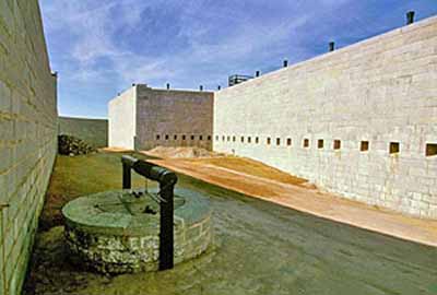
General view
© Parks Canada Agency/Agence Parcs Canada, J. Butterill, 1994.
Address :
Kingston, Ontario
Recognition Statute:
Historic Sites and Monuments Act (R.S.C., 1985, c. H-4)
Designation Date:
1923-05-25
Dates:
-
1832 to 1840
(Construction)
-
1832 to 1870
(Significant)
Event, Person, Organization:
-
Canadian Army
(Organization)
-
British Army
(Organization)
Other Name(s):
-
Fort Henry
(Designation Name)
Plaque(s)
Existing plaque: Mounted on the outside wall to right of main entrance Kingston, Ontario
An earlier fort was built here on Point Henry during the War of 1812 primarily to defend the nearby naval dockyard. When the Rideau Canal was built as part of a military route connecting Kingston and Montréal, the strategic importance of this site increased. The old fort was therefore replaced by the present structure of stronger and more advanced design which was completed in 1836 at a cost of over £70,000. Garrisoned by units of the British and then Canadian army until 1890, the fort never saw action, although it was used as a prison for rebels captured during the Rebellions of 1837-38.
Description of Historic Place
Fort Henry National Historic Site of Canada is a 19th-century British military fortress situated on Point Henry between the mouth of Kingston harbour and a second natural harbour at the mouth of the Cataraqui River. It sits high on a natural cliff facing the confluence of the eastern end of Lake Ontario with the beginning of the St. Lawrence River. The designation refers to the fort, its redoubt, advanced battery, the former ''dead zone'' to the north and east, and the associated cultural resources found thereon.
Heritage Value
Fort Henry has been commemorated as a national historic site of Canada because: of the fortification built on Point Henry beginning in 1832 for the defence of the Rideau Canal and the Naval Dockyard, and this site was the key fortification among a series of military works designed to defend Kingston and its harbour.
Construction of Fort Henry by the British military began in 1832, with the addition of ditch towers and commissariat casemates in 1840 to create its present configuration. The fort was garrisoned by units of the British Army until 1870, and then by Canadian forces. Although Fort Henry has never seen military action, it was used as a prison for combatants captured during the 1837-38 Rebellions and again during the first and Second World Wars. During the 20th century it was restored and interpreted for public visitation. Originally designated a national historic site of Canada in 1923, the fort also was designated part of the broader Kingston Fortifications National Historic Site of Canada in 1989.
The heritage value of this site is most critically represented by the surviving massing, form and fabric of the fort including the advanced battery, the redoubt and the glacis, as well as by its sense of scale and purpose.
Sources: Historic Sites and Monuments Board of Canada, Minutes, 1981; Commemorative Integrity Statement, Fort Henry, 1996; Commemorative Integrity Statement, Kingston Fortifications, 1999.
Character-Defining Elements
Elements key to the heritage value of this site include:
its elevated site at the confluence of major 19th-century shipping channels (Lake Ontario and the St. Lawrence River, Lake Ontario and the Rideau Canal); its strategic position between two harbours critical to securing the Kingston area (the Kingston harbour and the natural harbour at the mouth of the Cataraqui River); its symmetrical footprint which conveys a sense of enclosure; its generous scale and substantial stone construction materials; surviving elements of the original fortification, including the design, form and materials of the built and landscaped components; surviving elements of its evolved design including the ditch towers and commissariat stores; the skilled workmanship evident in its masonry work and assembly; surviving original interior layouts, fittings and finishings (including door hardware, flooring); surviving infrastructure details (such as cisterns, drains, masonry gutters); the integrity of associated buildings not connected to its walls (including two gun sheds, a barracks' store, the hospital guardhouse) in the surviving original design, forms, materials, and in
their locations and functional orientation in relation to each other and the fortification proper; archaeological evidence of other facilities within the fortification compound (such as the ordnance and engineer's yard, the former hospital, the magazine and officer's quarters dating from 1812, the wharf cribs on the shoreline south of the west branch tower) in their found location, footprints, remnant materials, and their strategic and functional location in relation to the Fort's buildings and fortifications, in particular the physical and associative relationship of the guardhouse to the former hospital building; the fort's strategic, functional, design and material relationships with other parts of the Kingston fortifications (i.e. Fort Frederick and the Martello Towers); viewscapes which reinforce the concept of inter-connecting fields of fire - east across Deadman's Bay to Cartwright Point, west to Navy Bay, Fort Frederick and the site of the former dockyard then across the mouth of the Cataraqui to Kingston's harbour and the Shoal Tower, south from the advanced battery to the north channel and the entrance to the harbour, north from the redoubt to the heights of land as far as Barriefield; cleared/open ground surrounding the site; the inter-relationship of the glacis with natural features surrounding the site (its profile and the need for a retaining wall on the north and along the shore of Deadman's Bay); the integrity of the boundary shorelines of Deadman's Bay and Navy Bay; historic routes and pathways (the access route to the west gate, the pathway to the swale) in their locations and extent; unobstructed viewplanes looking south from the entrance road up to the compound and the fortification; associated objects from the 1832-1870 period (including ordnance, gun carriages, gun platforms, munitions, ordnance implements, archaeological artifacts, personal items and furnishings, military manuals, books, diaries, plans, watercolours and sketches).