Athabasca Pass National Historic Site of Canada
Jasper National Park of Canada, Alberta
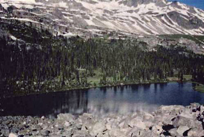
General view
© Jack Porter, Parks Canada Agency / Agence Parcs Canada, 1998.
Address :
Jasper, Jasper National Park of Canada, Alberta
Recognition Statute:
Historic Sites and Monuments Act (R.S.C., 1985, c. H-4)
Designation Date:
1971-05-27
Dates:
-
1811 to 1855
(Significant)
Event, Person, Organization:
Other Name(s):
-
Athabasca Pass
(Designation Name)
-
The Discoverer of Athabaska Pass
(Plaque name)
Research Report Number:
1971-006; 1960-044, 2004-023, 2005-SDC/CED-043
DFRP Number:
15412 00
Plaque(s)
Existing plaque: Near "the Committee's Punch Bowl" Alberta
In January 1811, David Thompson, guided by Thomas the Iroquois, was the first white man to cross the Rockies through this pass. Thence he led his party down the Wood River to the place on the Columbia River later called Boat Encampment. Governor George Simpson subsequently named the small lake at the top of the pass Athe Committee's Punch Bowl; - a reference to the London Committee of the Hudson's Bay Company. For almost half a century, the Athabasca Pass was Part of the main fur trade route between Canada and the Oregon country.
Original Plaque: Alberta
In midwinter, 1810-11, David Thompson, of the North West Company, with ten companions discovered and travelled through this pass to the Columbia River. It immediately became the regular route across the mountains and so continued until the advent of railway communication.
To David Thompson, Canada owes the first accurately prepared map of the Great West, embodying the results of his surveys and explorations from 1789 to 1812.
Description of Historic Place
Athabaska Pass National Historic Site of Canada is a route that crosses the Rocky Mountains, the height of land that forms the Continental Divide in western Canada. The pass forms a linear corridor of access over these mountains in an area of dramatic landscape composed of river, trail, trees, glaciers, lakes and rock formations. A geographic composite of elements whose character alters with the seasons, the pass becomes increasingly rugged as it ascends to meadows surrounding a small glacial lake at the summit. Rivers to the west drain into the Pacific while the eastern half drains into Hudson Bay. These mountains form the boundary between British Columbia and Alberta and the site is situated in both provinces. The Alberta side of the pass falls entirely within Jasper National Park of Canada and is administered by Parks Canada. The British Columbia side of the site is provincial crown land administered by the British Columbia Ministry of Forests. The headwaters of the Whirlpool River in Jasper National Park of Canada run through the pass and eventually connect into the Columbia River. Official recognition refers to the geographically definable location circumscribed by selected natural features and watercourses.
Heritage Value
Athabaska Pass was designated a national historic site of Canada in 1971 because: the Athabaska Pass was, for almost half a century, part of the main fur trade route between Canada and the Oregon country.
Between 1811 and the mid-1850s, the Athabaska Pass played an important role in the transportation routes of the fur trade of western North America. Its importance derived from its strategic location on the Continental Divide when traders, both British and American, were seeking to extend their commercial activity west of the Rocky Mountains. David Thompson, the noted surveyor and explorer, decided to search out a new route in order to get around the blockade mounted by the Piegan Indians. In January 1811, David Thompson, using traditional Aboriginal knowledge and guided by Thomas the Iroquois, crossed the Rockies through this pass and led his party down the Wood River to the place on the Columbia River later called Boat Encampment. Journeying over the pass in 1824, Hudson’s Bay Company Governor George Simpson named the small lake at the top of the pass “the Committee’s Punch Bowl” – a reference to the London Committee of the company. The Athabaska Pass route ensured continuity of service to the fur trade posts already established by Thompson in the upper and middle Columbia River Valley.
Source: Historic Sites and Monuments Board of Canada, Minutes, July 1971; July 2005; Commemorative Integrity Statement.
Character-Defining Elements
The key elements that contribute to the heritage character of this site include: the location in the dramatic, natural environment of the Rocky Mountains; the composition of geographical elements which constitute the pass including the mountains, river, trail, glaciers, vegetation, lakes and rock formations, evocative of this landscape at the time that it was used as a pass; the remains of the historic trail; the visual character along the corridor of the pass, meaning the unimpeded viewscapes of the surrounding mountains, forest and river; the integrity of any archaeological remains which may be found within the pass, including features and artefacts relating to the fur trade from the period between 1811 to the mid-1850s in their original placement and extent.