Old Wendake Historic District National Historic Site of Canada
Wendake, Quebec
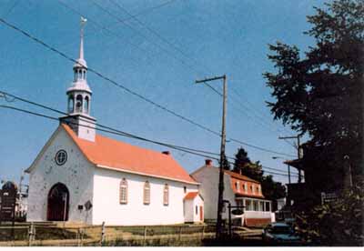
General view
© Olivier Larochelle, Parks Canada Agency / Agence Parcs Canada, 1999.
Address :
Wendake, Quebec
Recognition Statute:
Historic Sites and Monuments Act (R.S.C., 1985, c. H-4)
Designation Date:
2000-11-15
Dates:
-
1697 to 1697
(Significant)
-
1730 to 1730
(Significant)
-
1865 to 1865
(Significant)
Event, Person, Organization:
-
Dispersal of Huron-Wendat from Huronia National Historic Event
(Event)
-
Huronia
(People, group)
-
Huron-Wendat First Nation
(People, group)
Other Name(s):
-
Old Wendake Historic District
(Designation Name)
Research Report Number:
1999-053, 2008-SDC/CED-010
Description of Historic Place
Old Wendake Historic District National Historic Site of Canada is located 12 kilometres north-west of the City of Québec. Situated on the southern bank of the Saint-Charles River, near the Kabir-Kouba Falls, the site consists of mainly south-facing residential and commercial buildings that reflect the plan of a traditional Huron village. Main features of the site include a dense residential district of mainly single- and multi-family houses, the Notre-Dame-de-Lorette Church National Historic Site of Canada, two cemeteries, as well as multiple commercial and administrative buildings. Official recognition refers to the district and its constructed and natural features at the time of designation.
Heritage Value
Old Wendake Historic District was designated a national historic site of Canada in 2000 because: it is a remarkable example of a community which survived the dispersal of the inhabitants of Huronia, an event of national historic significance; the urban layout of Old Wendake recalls the traditional method of land use typical of the proto-historic Huron village, while its architecture reflects European building typology; it is an evolving cultural landscape which evokes the "reinstatement of Huron values."
The heritage value of this site resides in the topography and settlement forms of the district, including land-usage patterns and architecture that speak to the 300 years of settlement in this area. During the first half of the 17th century, the Huron-Wendat, who lived and farmed in Huronia just south of Georgian Bay in Ontario, became major fur trading partners with the French. In 1650, devastated by famine, conflict, and contagious diseases from Europe, the Huron-Wendat dispersed from their lands, establishing themselves permanently at Jeune-Lorette. The district was renamed Old Wendake in 1697.
Old Wendake Historic District presents an excellent example of co-existing cultural influences. Rather than adhering to a geometric plan, the district was constructed around natural elements. For example, the primary entrances of its buildings generally face south-east, regardless of which side of the lot faces the street. This layout is similar to traditional Huron villages, although many of the buildings were constructed in European-inspired styles after 1730. In addition, the street blocks are densely formed to allow for pedestrian traffic between houses, fostering a sense of community and public space while facilitating an economic system structured on the basis of cottage industries. The custom of naming streets after former chiefs of the nation demonstrates the relationship that the Huron-Wendat have with this site today, because it supports their collective memory, livelihood and history.
Sources: Historic Sites and Monuments Board of Canada, Minutes, June 2000, April 2008.
Character-Defining Elements
Key elements that contributes to the heritage character of the site include: its location 12 kilometres north-west of the city of Québec; its setting on the bank of the Saint-Charles River, near the Kabir-Kouba falls, partly on the original 1697 settlement established after the dispersal of Huron-Wendat from Huronia; its spatial configuration and orientation, including south-east facing entrances, implantation on parcels of land, position in relation with the roads leaving a large proportion of public space, and their agglomeration type including the permeable densely built residential sector; the significant physical features of buildings and structures as defined by scale, form, design and detailing, such as the eclectic mix of European-inspired building styles parallelling other local architectural developments, with features such as gable roofs with dormers, low-pitched roofs, mansard roofs, flat roofs; the predominent building materials, construction techniques and craftmanship applied to buildings and structures, including wood-frame structures, log constructions and the use of stone for high vertical structures; its mixed functions and uses that continue to occur in the district, including residential, commercial, institutionnal and administrative buildings; the landmarks of prominent features, including the Notre-Dame-de-Lorette Church National Historic Site of Canada; the cultural and historical associations manifested in the district, including the roads names referring to the Conseil de la Nation Huronne-Wendat Grand Chiefs, the houses of famous Nation members, and the cemeteries and historic memorials; the dominance of natural features along the periphery, including the Kabir-Kouba Falls and the Saint-Charles River.