Ruin of St. Raphael's Roman Catholic Church National Historic Site of Canada
St. Raphaels, Ontario
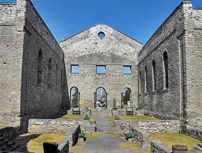
Interior view
© Flickr, guidedbycthulhu, 2009.
Address :
20000 King's Road (County Road 18), St. Raphaels, Ontario
Recognition Statute:
Historic Sites and Monuments Act (R.S.C., 1985, c. H-4)
Designation Date:
1997-09-22
Dates:
-
1815 to 1821
(Construction)
-
1821 to 1970
(Significant)
Event, Person, Organization:
-
Alexander Macdonell, Bishop
(Person)
Other Name(s):
-
Ruin of St. Raphael's Roman Catholic Church
(Designation Name)
-
St. Raphael's Roman Catholic Church
(Other Name)
Research Report Number:
1996-001
Plaque(s)
Existing plaque: 20000 King's Road (County Road 18), St. Raphaels, Ontario
The extraordinary ruins of this church recall the early history of Roman Catholicism in Upper Canada. Begun in 1815, St. Raphael's Church originally served as the centre of the colony's largest and most important parish, and the administrative headquarters for the first Roman Catholic bishop, Alexander Macdonell. Situated in the heart of a historic Highland settlement, the parish was the cradle of Catholicism in Ontario. The ruins left standing after the fire of 1970 serve as a testament to Bishop Macdonell's determined efforts to forward the interests of his faith.
Description of Historic Place
The Ruin of St. Raphael’s Roman Catholic Church National Historic Site of Canada is an evocative stone ruin set within a pastoral ecclesiastical landscape in South Glengarry County, Ontario. In 1970, St. Raphael’s roof, its 1830s tower and all of its 1900 interior decoration were destroyed by fire. The outer walls were spared and thus its plan, impressive scale and fine masonry work were preserved. The masonry shell of the formerly grand church is complemented by an old burial ground, a small modern church, and other ecclesiastical buildings that stand nearby. The designation refers to the church ruin on its footprint.
Heritage Value
The Ruin of St. Raphael’s Roman Catholic Church was designated a national historic site of Canada in 1996 because: it is one of the earliest Roman Catholic monuments in English-speaking Canada; it is a significant testament to the establishment of the Roman Catholic church in Upper Canada.
The heritage value of this site resides in its historical associations as illustrated by the well-preserved ruins of the former St. Raphael’s Roman Catholic Church set in an ecclesiastical precinct. The Ruin of St. Raphael’s Roman Catholic Church is also significant through its association with the first Roman Catholic Bishop of Upper Canada, Alexander Macdonell, who administered his see from this former church during the 1820s. Until the 1840s, St. Raphael’s parish was the largest and most important ecclesiastical district for Anglophone Catholics in Upper Canada. The ruin, set in an ecclesiastical precinct, is part of a rich historic landscape that includes a burial ground, as well as numerous historic and modern ecclesiastical buildings.
Bearing witness to the early history of Roman Catholicism in Upper Canada, the Ruin of St. Raphael’s Roman Catholic Church is evidence of a formerly grand church, whose plan had been inspired by Québec churches designed by Reverend Pierre Conefroy. Begun as early as 1815, St. Raphael’s was situated in the heart of an early Highland Scottish settlement, and for the next half-decade, its parish would be the cradle of Catholicism in Ontario. St. Raphael’s suffered a devastating fire in 1970, leaving the current ruin, which has since been stabilized. Today, this ruin serves as an evocative testament to Bishop Alexander Macdonell’s determined efforts to establish the Roman Catholic Church in Upper Canada.
Sources: Historic Sites and Monuments Board of Canada, Minutes, June 1996; Commemorative Integrity Statement, 1999.
Character-Defining Elements
The key elements that contribute to the heritage character of this site include: its location on what was the old King’s Road in South Glengarry County; its setting as part of an ecclesiastical precinct in a pastoral landscape; the integrity of the ruin, namely the surviving layout, elevations, and interior and exterior detailing of the well-crafted cut stone walls; evidence of its relatively large size and cruciform plan with semi-circular apse as defined by the surviving footprint; evidence of the simple Palladian design in the entry facade with wide triangular pediment and giant Tuscan pilasters framing a three-bay composition, and in the regularly spaced, round-headed window openings on all elevations; the continued spatial relationship between the ruin and the remains of the two bells from the steeple, partially melted in the fire, and the surviving rooster from the steeple’s weather vane, in their respective locations on the surrounding grounds; the location, extent and materials of above and below ground archaeological artifacts and remains relating to the original church; the physical relationship and viewscapes between the ruin and its surrounding historic elements within the ecclesiastical precinct, that include the burial ground, the 1808 Bishop’s Residence, the 1818 Bishop’s garden, the militia parade ground between the burial ground and the old King’s Road, and the 1889 rectory; the physical relationship and viewscapes between the ruin and its surrounding modern elements within the ecclesiastical precinct, including the present church, built in 1973 against the southwest corner of the ruin, the school building, and additions made to the Bishop’s Residence.