Beausoleil Island National Historic Site of Canada
Georgian Bay Islands National Park of Canada, Ontario
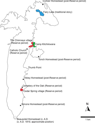
Map of the island
© Parks Canada / Parcs Canada, 2009
Address :
Beausoleil Island, Georgian Bay Islands National Park of Canada, Ontario
Recognition Statute:
Historic Sites and Monuments Act (R.S.C., 1985, c. H-4)
Designation Date:
2011-07-19
Dates:
-
1838 to 1856
(Flourished)
Event, Person, Organization:
-
Anishinaabeg of the southern Georgian Bay region
(People, group)
Other Name(s):
-
Beausoleil Island
(Designation Name)
-
Pamedenagog, Baamidoonegog, Epenmindaagoog
(Other Name)
Research Report Number:
2005-022, 2007-057, 2007-058, 2005-024, 2009-057
Description of Historic Place
Beausoleil Island National Historic Site of Canada is the largest island in Georgian Bay Islands National Park of Canada, located at Severn Sound, southern Ontario. Archaeological finds demonstrate human activity and settlement on the island from the late Paleo-Indian period to the present day. Used by the Anishinaabeg as a traditional stopping place, seasonal campsite and a reserve in the mid-19th century, the island’s cultural landscape features speak to traditional Anishinaabe narratives, to the Reserve period, and to the post-Reserve period. The island is named after Louis Beausoleil, a Métis settler whose 1819 homestead stood at the island’s southern tip. The landscape consists of swamp and Canadian Shield. Official recognition refers to the entirety of the island bounded by the high water mark of Georgian Bay.
Heritage Value
Beausoleil Island was designated a national historic site of Canada in 2009 because:
- it is representative of the cultural landscape of the Anishinaabeg of the southern Georgian Bay region, demonstrating the land's role as a place of memory, illustrating their people's relationship with the land, and recalling the Anishinaabe presence in Southern Ontario and their subsequent displacement;
- it is the setting for traditional narratives that record the island's creation and meaning. Many of the traditions associated with the island relate to women, including their use of Beausoleil for gathering berries and other plants, and for traditional ceremonies such as girlhood to womanhood transformation rituals; and,
- witness to a long history of settlement, the evolving landscape of the island includes evidence of ancient camps and of its brief period as a reserve in the mid 19th century when the Anishinaabeg struggled to find a new way to live that was compatible with their traditions and with the rapidly growing Euro-Canadian settlement surrounding them.
As a cultural landscape Beausoleil Island represents aspects of the relationship that evolved over the centuries between the Anishinaabeg of the southern Georgian Bay area and their ancestral territories. It is the setting of many Anishinaabe oral traditions and serves as a physical link to the resources, routines and ceremonies that reflect their traditional way of life and anchor their collective memory and culture.
Known to the Anishinaabeg as a “rocky place floating about the mouth of a river”, Beausoleil Island (1089 hectares) has been inhabited by humans on an irregular basis since the late Paleo-Indian period ca. 10400-9500 BP. Representative of the Anishinaabe presence in southern Ontario it is among the earliest sites of human occupation in the province. The island was well-known to Aboriginal peoples as a bad weather refuge and stopping place and supported two villages during the Reserve period (1838-1856). Chief John Assance led his people to Beausoleil Island after having ceded their lands at Coldwater. Assance’s band settled on the island`s leeward side at Cedar Spring. By 1844, there were 14 houses, a barn, one hundred cultivated acres and a cemetery. Assance had a small Roman Catholic Church constructed, and a schoolhouse was completed in 1847. YMCA Camp Kitchewa, the second Reserve period village to the north, comprised at least fifteen dwellings and perhaps a church. Poor soil and a relatively large population made long term settlement and attempts at agriculture in the European manner unsuccessful. Some moved to settle nearby Christian Island as early as 1844. By 1852 most of Assance’s band had followed. The Anishinaabeg who remained on Beausoleil Island established homesteads, mainly on the southeast of the island, and lived traditionally by fishing, hunting and gathering.
Source: Historic Sites and Monuments Board of Canada, Minutes, July 2009
Character-Defining Elements
Key features contributing to the heritage value of this site include:
- the location in the south-eastern arm of Georgian Bay in southern Ontario;
- the visual character, unspoilt geography, composition and landscape of the 1089 hectare island evocative of the Reserve Period, including the landscape at its southeastern end where farm fields and building depressions can still be discerned;
- the in situ remains of the 19th century Anishinaabe settlements, including building depressions and the integrity of identified, and as yet unidentified, archaeological remains in their original placement and extent;
- the retention of knowledge associated with all artefacts associated with the site including those relating to the Late Palaeo-Indian Period (ca.10400-9500 BP), the Late Woodland Period, and numerous 19th century artifacts
including Reserve period clay pipes, the 1833 bank token, and the metal kettle;
- the integrity of the undisturbed unmarked burial areas and the continued integrity of the recognized Cemetery of the Oak;
- the unimpeded viewscapes to and from the island.