Model City of Mount Royal National Historic Site of Canada
Mont-Royal, Quebec
General view
© Parks Canada Agency / Agence Parcs Canada, 2007.
Address :
Centennial Square (corner Laird Boulevard and Moyle Road), Mont-Royal, Quebec
Recognition Statute:
Historic Sites and Monuments Act (R.S.C., 1985, c. H-4)
Designation Date:
2008-04-11
Dates:
-
1915 to 1975
(Construction)
-
1915 to 1939
(Significant)
-
1939 to 1960
(Significant)
-
1960 to 1975
(Significant)
-
1912 to 1912
(Significant)
-
1914 to 1914
(Significant)
-
1917 to 1918
(Significant)
Event, Person, Organization:
-
Frederick Gage Todd
(Architect)
-
Thomas Darling
(Architect)
Other Name(s):
-
Model City of Mount Royal
(Designation Name)
Research Report Number:
2007-046
Plaque(s)
Existing plaque: Centennial Square (corner of Laird Boulevard and Moyle Road), Mont-Royal, Quebec
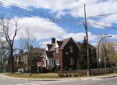
Located in the centre of the Island of Montréal, the “model city” of Mount Royal is an outstanding example of a planned community in Canada. In 1910, the Canadian Northern Railway envisioned, as a speculative venture, construction of a quiet suburb linked by rail to the downtown core. Incorporated in 1912, and designed by Frederick Gage Todd, the town completed over the next six decades reflects the influence of landscape architecture and urban planning following principles of the Garden City and City Beautiful movements. A railway station and a public square where two main boulevards and the railway converge anchor the town’s radial plan. An orthogonal grid, designed to maximize sunlight for homes, was superimposed on the plan. Winding streets enhanced by green spaces and varied plantings complete the presentation. The combination of low residential density and lush vegetation give the suburb the feel of an urban park. A finely executed design with exceptional integrity, Mount Royal is a remarkable synthesis of the creative urban planning movements of the early 20th century.
Description of Historic Place
The Model City of Mount Royal National Historic Site of Canada is a large residential suburb located north-west of Mount Royal on in the heart of Montreal Island, Quebec. The current site reflects the original concept of the district plan designed prior to 1914 and built gradually until the 1970s. It consists mainly of residential buildings, ranging from small single-family houses to multi-dwelling complexes, while businesses, schools and churches are situated along strategic arterials. The historic district is equally characterized by its main streets and parkways, its urban fabric and its numerous green spaces, both public and private. Official recognition refers to most of the limits of the original plan as drawn in 1914, which can still be seen today, but not to those areas which have undergone significant changes.
Heritage Value
The Model City of Mount Royal was designated a National Historic Site of Canada in 2008 because: from a design perspective, its remarkable synthesis of urban renewal movements of the early 20th century, reflecting the influence of the City Beautiful, Garden City and Garden Suburb movements, the quality of its construction, and its high level of integrity make it an outstanding example of a planned community in Canada; the breadth of its realization illustrates the role of the speculative and real estate activities of the railway companies; its organization and construction over decades reflect changes occurring in urban planning in the early 20th century, as well as the impact of landscape architects on urban planning with their insistence on a long-term perspective.
The Model City of Mount Royal was planned as a whole by landscape architect Frederick Gage Todd in 1914, and built in three successive phases, each lasting about 20 years, until the mid 1970s. The three phases of construction are defined on the basis of geographic factors, the construction of infrastructures and the number and type of erected structures. The historic community is nonetheless remarkably homogeneous, thanks to the long-term plan on which this independent urban project was based, starting with the original plan and progressing through the stages of execution and supervision by the city.
The Model City of Mount Royal was created as a response to industrialization and big-city problems that plagued large metropolitan centres during the late 19th and early 20th centuries, as part of the urban renewal movement carried on in large Canadian cities by landscape architects. The Model City of Mount Royal is the result of the convergence, in a single project, of the different concepts of the Urban Park, City Beautiful and Garden City movements reaching its point of maturity, as expressed through the presence of a railway, main arterials, winding parkways, and its zoning and layout.
The creation of the Model City is also associated with the speculative and real estate activities carried out by railway companies. By hiring Todd to draw the plans, the railway speculators aimed to turn a profit from the railway and the tunnel under Mount Royal by the Canadian Northern Railway. By creating an attractive suburb, they were making sure they could sell their lots. This close link between the railroad company, the speculators and the creation of the model city still represents an important symbol of the city, as evidenced by the simple grid-like street layout and the prime location of the train station and tracks.
Sources: Historic Sites and Monuments Board of Canada, Minutes, 2007, SDC Report, 2007 - 46.
Character-Defining Elements
Key elements that contribute to the heritage character of the site include: its location north-west of Mount Royal at the heart of Montreal Island, Quebec; its clearly defined boundaries: the Trans-Canada Highway and its opaque wall to the north; de l’Acadie Boulevard, the chain-link Frost fence and landscape features to the east; and the urban and landscaped environment to the west and south; the major elements of the subsisting original urban layout, including the grid street pattern, the large diagonal boulevards and their right-angle intersections with the streets, the large lots oriented to maximize sun exposure, as well as the wide, meandering parkway and many green spaces; the almost exclusively residential building type which has been preserved since the original plan and which promotes homogeneity in long-term planning; the public, institutional, religious and educational buildings located along the major boulevards; the road, rail and municipal infrastructures built during the three phases of development; the residential units dating from the first phase of construction, including mostly two-storey duplexes and single-family units designed to models proposed by the developer with influences of the English vernacular, garages at the back of the lots, and lots measuring 10 to 12 metres; the residential units dating from the second phase of construction including the single, two-storey homes inspired by the English manor, New England houses and Canadian houses, garages attached to homes, and lots measuring 15 to 22 metres; the residential units dating from the third phase of construction, including multi-dwelling buildings, two-storey cottages, bungalows and split-levels homes, built-in garages, and lots measuring 20 to 25 metres; the relatively diverse building materials, with wood, brick and stone in the early stages, followed later by artificial stone, plaster and their variations in accordance with municipal bylaws; the landscaping, including the trees of various sizes, ages and species, such as Norway maples, which form a vaulted canopy over narrow streets and line the boulevards; and the grassy areas that serve as a buffer between public and private property; the characteristics of the City Beautiful movement, including the cohesive organization of the original plan, the curving and straight-lined plots, and the broad boulevards lined with institutions and apartment buildings leading to the central public square; the characteristics of the Garden City principle, including the integration of the railway, the separation of the functional zones within the city (industries around the edges and institutions in the centre), and the distinction between residential streets and the main arterials; the characteristics of the suburban city principle derived from the Garden City movement, including the adaptation of the growing suburb and the separation of functions in city planning; the close link between the railway, the speculators and the creation of the Model City as evidenced by the criss-cross street pattern; the prime location of the railway track and station in the central square; and by the streets named to preserve the link with the railway or in honour of the investors; the viewscapes within the site which give a complex labyrinth-like impression, filled with trees and meandering lines, creating a powerful residential intimacy.