Tilting National Historic Site of Canada
Tilting, Newfoundland and Labrador
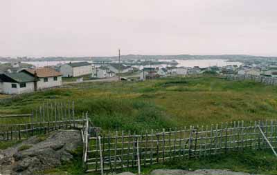
General view
(© Parks Canada Agency / Agence Parcs Canada, Rhona Goodspeed, 2001.)
Address :
Tilting, Newfoundland and Labrador
Recognition Statute:
Historic Sites and Monuments Act (R.S.C., 1985, c. H-4)
Designation Date:
2003-06-30
Dates:
-
1730 to 1992
(Construction)
Other Name(s):
-
Tilting
(Designation Name)
-
Tilting Cultural Landscape
(Other Name)
Research Report Number:
2002-041
Plaque(s)
Existing plaque: Tilting, Newfoundland and Labrador
Irish settlers began to shape this landscape from about the 1730s, building houses and fishing rooms around the harbour to support the inshore fishery. Influenced by the inheritance customs of their homeland, Tilting's residents subdivided the original land lots, developing clusters of extended family neighbourhoods. They also adapted the Irish tradition of keeping gardens, with those near the home more intensively cultivated and those farther away used mainly for hay or crops for winter storage. Like other Newfoundlanders, they enclosed their fields with wooden fences and pastured livestock on the open commons. Many of Tilting's landscape components, including the harbour, the extensive gardens near Sandy Cove and Oliver's Cove, and the summer and winter paths, are used in much the same way today as in the past. While continuing to evolve, this community retains an unusually complete range of vernacular building types, and the arrangements and interrelationships of traditional buildings and spaces have largely been maintained. Still inhabited by descendants of its early families, Tilting survives as a rare example of a once common Irish- Newfoundland cultural landscape.
Description of Historic Place
Tilting National Historic Site of Canada is an outport landscape created by a coastal fishing community on the east coast of Fogo Island in Notre Dame Bay on Newfoundland’s northeast coast. The site includes small wooden vernacular dwellings and outbuildings as well as more modern structures scattered on the rocky island landscape, surrounded by gardens, pathways, the shoreline and the harbour. It is a continuing cultural landscape that encompasses natural, built and living places that together depict traditional outport life. The designation refers to the cultural landscape with its buildings and structures, including Pigeon Island and Tilting Harbour.
Heritage Value
Tilting was designated a national historic site of Canada in 2002 because: it possesses a landscape illustrating adaptations of Irish settlement patterns, both in its family neighbourhood clusters around the harbour and its remarkable fenced gardens; it is a rare surviving example of a Newfoundland outport where the use of its landscape components has been very largely maintained from at least the mid-18th century, when its Irish settlers first began to shape them; it is a rare example of an outport that retains both a virtually complete range of traditional buildings and spaces associated with Newfoundland’s inshore fishery, and their traditional interrelationships.
An outport community that began to take shape in the 1730s, Tilting is a small community whose residents have long been dependent upon animal husbandry, farming and fishing. The designated site comprises landscape, shoreline, harbour, ponds, small island, one summer trail and portions of two others, portions of slide paths, three cemeteries, gardens, fences, buildings including a church, parish hall, former school, post office, two stores, houses, and a range of outbuildings including fishing buildings, stables, barns, one milk shed, haysheds and root cellars.
The heritage value of Tilting resides in the ability of the cultural landscape to illustrate the outport way of life. Value lies in the nature, diversity and range of the individual resources within its cultural landscape, their complex interrelationships, and the clarity with which their composition, forms and settings reflect the community’s Irish roots and on-going evolution.
Source: Historic Sites and Monuments Board of Canada, Minutes, December 2002.
Character-Defining Elements
Key features contributing to the heritage value of this site include: the natural setting with its uneven, undulating coast line, terrain that slopes upward from the harbour to a 50-metre height, a harbour shielded by Pigeon Island and flanked on either side by coves, one with a separate natural pond; the found cultural landscape with its component parts; the land-use patterns derived from the Irish tradition; the settlement clusters of family neighbourhoods grouped around Tilting Harbour; the spatial inter-relationships of associated site elements; evidence of the on-going evolution of the site since the 1730s; the vernacular architectural traditions (folk and modern), with one- and two- to two-and-a-half-storey wooden buildings representing a broad range of functional building types (houses, outbuildings, stores and public buildings); the contrasting presence of modern buildings with their distinctly different architectural forms, massing, materials and North American-off island roots; the similar interior layouts of the houses, finishing features, and siting patterns; evidence of longstanding patterns of farming in infield and outfield gardens, defined by siting, planting, harvesting and enclosure practices including the fencing of gardens; evidence of longstanding patterns of open-field grazing; evidence of coastal fishing practices illustrated by the settings and material remnants of the fishing berths; evidence of longstanding circulation and land-use patterns representing domestic routines such as obtaining fresh water, washing clothes and hauling wood; evidence of the use of traditional, locally available building materials, notably wood, in buildings, working objects (boats, fish traps, berth rings), and landscape features (fences); integrity of the three on-site cemetery landscapes; the road encircling the harbour; the presence of pathways joining buildings, spaces, clusters as well as walking trails and winter paths to neighbouring areas; the practice of naming landscape features to indicate their function or meaning to the community.