Fort Laprairie National Historic Site of Canada
La Prairie, Quebec
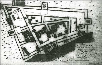
A map of the fort
(© Library and Archives Canada | Bibliothèque et Archives Canada / RG 84, series A-2-a, volume 1240, file HS7-4, reel T-14012)
Address :
Émile-Gamelin Street, La Prairie, Quebec
Recognition Statute:
Historic Sites and Monuments Act (R.S.C., 1985, c. H-4)
Designation Date:
1921-05-21
Dates:
-
1687 to 1689
(Construction)
-
1705 to 1705
(Significant)
Event, Person, Organization:
-
First Battle of Laprairie
(Event)
-
Robert de Villeneuve
(Architect)
-
Gédéon de Catalogne
(Builder)
Other Name(s):
-
Fort Laprairie
(Designation Name)
-
First Battle of Laprairie
(Plaque name)
Research Report Number:
2010-CED-SDC-001
Plaque(s)
Original plaque dismantled / removed / replaced: Laprairie, Quebec
Built between 1687 and 1689, Fort Laprairie was used as a refuge and a defensive outpost for Montréal during a time of European conflict that increased existing tensions between the Haudenosaunee Confederacy and French settlers. In 1691, a force of French, Huron-Wendat, Anishinabeg, Kanien’kehá:ka (Mohawks) of Kahnawake and Kanesatake, and other First Nations defeated an attack by a group composed of Kanien’kehá:ka, Mohicans, and New York militia at Laprairie. The fort fell out of use following the 1713 Treaty of Utrecht. Few traces remain, yet the fort’s shape can be seen in the layout of surrounding lots and streets.
Description of Historic Place
Fort Laprairie National Historic Site of Canada is located on the western bank of the St. Lawrence River in La Prairie, Quebec. The site consists of a 17th-century French Regime fort, of which there are no visible remains. Constructed in 1687, Fort Laprairie and its palisade, which enclosed some of the village buildings, served as a defensive outpost and as a refuge for settlers until 1713. The trapezoid shape of the fort influenced the formation and layout of lots and roads in what is now a residential area. Official recognition refers to the footprint of the fort at the time of designation.
Heritage Value
Fort Laprairie was designated a national historic site of Canada in 1920. It is designated because: from 1687 to 1713, Fort Laprairie served as a refuge for settlers and a defensive outpost for Montréal.
Fort Laprairie was designed in 1687 by Robert de Villeneuve and built the same year by Gédéon de Catalogne, both official engineers of the French colonial troops. The fort served as a defensive outpost for Montréal during the War of the Grand Alliance and the War of the Spanish Succession. From 1687 until the Peace of Utrecht in 1713, the fort was continuously garrisoned settlers took refuge inside the palisade on several occasions. For example, in August 1691, during the First Battle of Laprairie, the French defended the fort from an attack by New England Militia troops. The fort is reputed to have saved the lives of its occupants during this encounter. After withstanding numerous attacks by the English militia and the Iroquois, Fort Laprairie was largely destroyed when the Americans retreated following the Invasion of Canada in 1775.
Source: Historic Sites and Monuments Board of Canada, Minutes, February 2010; Plaque Text, June 1980.
Character-Defining Elements
Key elements that contribute to the heritage character of the site include: its location in La Prairie, near Montreal; its strategic siting on the western bank of the St. Lawrence River; its trapezoid shape, which influenced the formation and layout of lots and roads in the area; any archaeological remains related to the palisade; the integrity of any surviving or as yet unidentified archaeological remains, which may be found within the site in their original placement and extent relating to the site’s use as a fort during the period from 1687 to 1775; viewscapes overlooking the St. Lawrence River.