
Two different sectors in the park
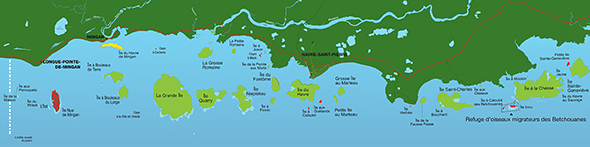
The first sector includes most of the islands found in the Western region of the archipelago (the park's most frequented and well-used area). This portion contains the majority of the park's limestone islands and monoliths. It is situated between Île aux Perroquets, facing Longue-Pointe-de-Mingan, and Île Sainte-Genevieve.
Map of the Western sector of the Archipelago
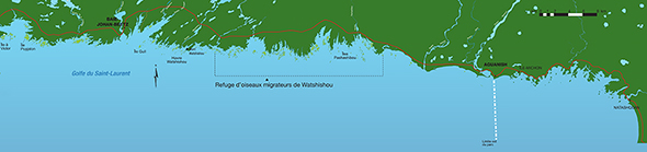
The second sector, the Eastern region of the park, comprises most of the granite islands, islets and keys-nearly 1000 in total-found east of Île Saint-Genevieve and extending to the mouth of the river Aganus, near Aguanish.
Map of the Eastern Sector of the Archipelago
Detailed Maps in PDF format
Campgrounds
Grande Île
- Barachois à Montpetit (PDF, 708 Kb)
- Havre à Petit-Henri (PDF, 2.6 Mb)
Île à la Chasse
- Havre à Landry (PDF, 645 Kb)
Île du Havre
- Anse des Noyés (PDF, 562 Kb)
- Havre au Sauvage (PDF, 1.05 Mb)
Île Niapiskau
- Anse du Noroit (PDF, 535 Kb)
Île Nue de Mingan
- Île Nue de Mingan (PDF, 526 Kb)
Île Quarry
- Baie Quarry Est (PDF, 2.5 Mb)
- Baie Quarry Ouest (PDF, 813 Kb)
Hiking Trails
- Île du Havre (PDF, 2.5 Mb)
- Île Quarry (PDF, 2.6 Mb)
- Grande Île (PDF, 2.9 Mb)
- Île Nue de Mingan (PDF, 3.3 Mb)
- Île Niapiskau (PDF, 2.1 Mb)
- Île du Fantôme (PDF, 1.7 Mb)
- Grosse Île au Marteau (PDF, 2.7 Mb)
- Petite Île au Marteau (PDF, 2.6 Mb)
- Île aux Perroquets (PDF, 2.3 Mb)
More information on the Islands
- Date modified :