
© Paul Zizka Photography
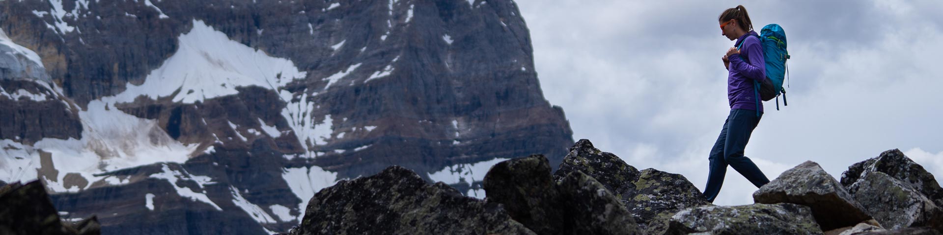
Day hikes
Yoho National Park
With ample waterfalls and glaciers, Yoho National Park is a hikers paradise. Trails range from easy to difficult allowing something for everyone. Plan your trip using our trail descriptions, packing lists and safety information. For maps and detailed routes, call or visit the Yoho Visitor Centre.
For maps, detailed route finding and trail descriptions, visit the Yoho Visitor Centre or purchase a hiking guide book and topographical map. Note: There is limited cell service in Yoho National Park.
Safety
Safety is your responsibility. There are always hazards associated with outdoor recreation. Even short trips can have serious consequences. Minimize your risk by planning ahead.
- Check the weather forecast, current trail conditions, warnings and closures or visit a Parks Canada visitor centre.
- Be prepared for emergencies and changes in weather. Mountain weather changes quickly and it can snow any month of the year. Dress in layers, bring extra food and warm clothing.
- Study descriptions and maps before heading out. Always choose a trail suitable for the least experienced member in your group.
- Bring your own water. Surface water may be contaminated and unsafe for drinking.
- Carry a first aid kit and bear spray.
- Tell a reliable person where you are going, when you will be back, and who to call if you do not return: Parks Canada Dispatch – 403-762-1470.
- Ticks carrying Lyme disease may be present in the park. It is important to check yourself and your pet after hiking.
- Avoid wearing earbuds or headphones. Be alert at all times.
- In case of EMERGENCY, call 911 or satellite phone: 403-762-4506. Cell phone coverage is not reliable throughout the national park.
Snowy trails
Snow can remain on some trails well into the summer. When trails are snow covered, route finding can be difficult and travel through deep snow or on hard snow and ice can be unsafe. Be prepared and check trail conditions before heading out.
Seasonal avalanche risk

Trails above tree line (2,000 m) may be exposed to avalanche hazard at any time of the year and especially from November through June. Steep slopes that are snow covered have the potential to avalanche. For more information on the avalanche hazard, visit a Parks Canada visitor centre or check the Mountain Safety section.
Recommended Packing List
- Trail guide and map
- Full water bottle or thermos
- High energy food
- Bear spray
- Sunscreen and sunglasses
- First aid kit
- Headlamp or flashlight with spare batteries
- Hat and gloves
- Hiking poles
- Rain/wind jacket
- Extra warm clothing in case of an emergency
- Cell phone or satellite emergency communication device.
Trail Etiquette
Show courtesy to fellow trail users!
- Leave what you find —it is the law. Natural and cultural resources such as rocks, fossils, artifacts, horns, antlers, wildflowers and nests are protected by law and must be left undisturbed for others to discover and enjoy.
- Dispose of human waste at least 100 m from any water source. Bury solid human waste in a hole 15 cm deep. Pack out your toilet paper.
- To prevent damage to vegetation, stay on designated trails at all times.
- Trails are used by a variety of outdoor enthusiasts. Be sure to yield to others.
- Leave no trace. Pack out everything you pack in.
Wildlife and people

Yoho National Park is home to wildlife including elk, wolves, cougars, grizzly bears and black bears. To successfully raise their young and sustain a healthy population, wildlife need access to as much quality habitat with as few human surprises as possible.
Be aware of possible encounters with wildlife in all areas of the park, including paved trails and roads.
Tips
- Always carry bear spray, ensure it is accessible, and know how to use it before heading out.
- Make noise. Being quiet puts you at risk for sudden wildlife encounters. Be alert through shrubby areas and when approaching blind corners. Travel in tight groups and always be aware of your surroundings.
- Report bear, cougar, wolf and coyote sightings and encounters to Parks Canada Dispatch when it is safe to do so: 403-762-1470.
- Keep dogs on leash and under control at all times.
More information
Trail Ratings
|
Easy |
|
|
Moderate |
|
|
|
|
| Estimated time to complete these trails ranges depending on trail distances, fitness levels, weather and trail conditions. | |
Map: Yoho National Park trail map
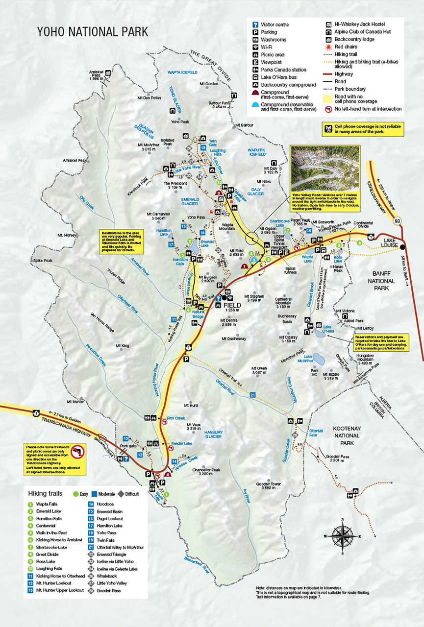 </figureclass="image">
| Trail |
Distance (return) | Time (return) | Elevation gain |
|---|---|---|---|
 Sherbrooke Lake Sherbrooke Lake |
6.2 km | 3 hours | 165 m |
| Laughing Falls |
7.8 km | 3.5 hours | 125 m |
 Kicking Horse to Otterhead Kicking Horse to Otterhead |
12.6 km | 4.5 hours | 40 m |
| Mt. Hunter Lower Lookout |
7.2 km | 3 hours | 410 m |
| Mt. Hunter Upper Lookout |
12 km | 5.5 hours | 885 m |
| Hoodoos |
5.2 km | 2.5 hours | 325 m |
| Emerald Basin |
9.2 km | 3.5 hours | 225 m |
| Paget Lookout |
7 km | 3 hours | 520 m |
| Hamilton Lake |
11 km | 5 hours | 850 m |
| Yoho Pass |
12.8 km | 5 hours | 530 m |
| Twin Falls |
16.4 km | 6 hours | 300 m |
| Ottertail Valley to McArthur Creek |
32.4 km | 9 hours | 285 m |
 Emerald Triangle Emerald Triangle |
19.7 km | 8 hours | 880 m |
| Iceline via Little Yoho |
20.8 km | 8 hours | 710 m |
| Iceline via Celeste Lake |
17.5 km | 7 hours | 695 m |
| Whaleback |
21.3 km | 7.5 hours | 700 m |
| Little Yoho Valley |
18.6 km | 7 hours | 520 m |
Thanks to an ongoing collaboration between Parks Canada and Google, you can now explore some Yoho National Park highlights using Street View for Google Maps.
Trail Descriptions
 Easy Trails
Sherbrooke Lake
Length: 6.2 km
Hiking time: 2.5 hours
Elevation: 165 m
Trailhead: Parking lot on the north side of the Trans-Canada Highway, 11 km east of Field, B.C. across from Wapta Lake. Note: The trailhead is not marked for eastbound traffic as the highway is divided. Continue east for another 2 km to the Lake O’Hara Road, turn around and come back on Highway 1 west. (map)
Habitat: Typical Rocky Mountain forest with avalanche debris at the lake. Part of an important wildlife corridor.
Description: A moderate, forested hike to a glacial lake rimmed with thick vegetation and avalanche debris.
Laughing Falls
Length: 8.8 km
Hiking time: 3 hours
Elevation: 125 m
Trailhead: Takakkaw Falls parking lot, 17 km northeast of Field via the Trans-Canada Highway and Yoho Valley Road. Note: Yoho Valley Road is open mid-June through mid-October. Vehicles over 7 m (23 ft) in length must reverse in order to navigate around the tight switchbacks. Trailers are not permitted. (map)
Habitat: Typical Yoho forest with moist groundcover. Watch for the very large fallen tree en route.
Description: A forested trail to a waterfall at the confluence of the Yoho and Little Yoho Rivers.
Backpacking: This trail leads to the Laughing Falls backcountry campround and is an access point for popular multiday backpacking routes.
 Moderate Trails
Kicking Horse to Otterhead
Length: 12.6 km
Hiking time: 4.5 hours
Elevation: 40 m
Trailhead: Natural Bridge parking lot, 4 km west of Field, B.C. via the Trans-Canada Highway and Emerald Lake Road. (map)
Habitat: At the confluence of three important valleys. Watch for wolf tracks.
Description: Walk or cycle an old fire road along the Kicking Horse River to the Otterhead River.
Mt. Hunter Lookout
Length: 7.2 km
Hiking time: 3 hours
Elevation: 410 m
Trailhead: Across from Wapta Falls Road, 25 km west of Field, B.C. on the north side of the Trans-Canada Highway. Note: The trailhead is not marked for westbound traffic as there is no left turn lane here. Continue west for another 5.5 km to the park west boundary, turn right at the Beaverfoot exit and come back on highway 1 east. (map)
Habitat: Forest leading to a fire lookout. Watch for artifacts from earlier eras.
Description: A steep trail through an open forest to a historic fire lookout tower.
Mt. Hunter Upper Lookout
Length: 12 km
Hiking time: 5.5 hours
Elevation: 835 m
Trailhead: Across from Wapta Falls Road, 25 km west of Field, B.C. on the north side of the Trans-Canada Highway. Note: The trailhead is not marked for westbound traffic as there is no left turn lane here. Continue west for another 5.5 km to the park west boundary, turn right at the Beaverfoot exit and come back on highway 1 east. (map)
Habitat: A drier, more exposed forest leading to a fire lookout and rocky ridge beyond.
Description: A steep trail to a historic fire lookout tower and beyond to views of the Kicking Horse and Beaverfoot Valleys.
Hoodoos
Length: 5.2 km
Hiking time: 2.5 hours
Elevation: 325 m
Trailhead: Hoodoo Creek Campground, 23 km west of Field, B.C. on the Trans-Canada Highway. (map)
Habitat: Watch for goat licks in the dry, light coloured soil here under the roots of trees.
Description: A steep, dry, exposed trail leading to hoodoos or capped pillars of glacial debris.
Emerald Basin
Length: 9.2 km
Hiking time: 3.5 hours
Elevation: 225 m
Trailhead: Emerald Lake parking lot, 10 km west of Field via the Trans-Canada Highway and Emerald Lake Road. (map)
Habitat: Lush forest, at times dense, climbing a lateral moraine to a hydrological basin and avalanche paths. Watch for bears.
Description: Start along the shore of Emerald Lake then travel through ancient stands of hemlock and cedar to a natural amphitheatre.
Paget Lookout
Length: 7 km
Hiking time: 3 hours
Elevation: 520 m
Trailhead: Parking lot on the north side of the Trans-Canada Highway, 11 km east of Field, B.C. across from Wapta Lake. Note: The trailhead is not marked for eastbound traffic as the highway is divided. Continue east for another 2 km to the Lake O’Hara Road, turn around and come back on Highway 1 west. (map)
Habitat: Lush forest rising into the subalpine. Watch for mountain goats on Mt. Bosworth.
Description: A steep, rocky trail to views of the Bow, Cataract Book and Kicking Horse Valleys.
Hamilton Lake
Length: 11 km
Hiking time: 5 hours
Elevation: 850 m
Trailhead: Emerald Lake parking lot, 10 km west of Field, B.C. via the Trans-Canada Highway and Emerald Lake Road. (map)
Habitat: Lush forest rising steeply into subalpine and rocky alpine habitats. Watch for spruce grouse.
Description: A steep and steady climb to a classic, cliff-encircled alpine tarn.
Yoho Pass
Length: 12.8 km
Hiking time: 5 hours
Elevation: 530 m
Trailhead: Emerald Lake parking lot, 10 km west of Field, B.C. via the Trans-Canada Highway and Emerald Lake Road -OR- Takakkaw Falls parking lot, 17 km east of Field, B.C. via the Trans-Canada Highway and Yoho Valley Road. Note: Yoho Valley Road is open mid-June through mid-October. Vehicles over 7 m (23 ft) in length must reverse in order to navigate around the tight switchbacks. Trailers are not permitted. (map)
Habitat: Lush Columbian forest. Watch for goats on the Burgess Highline.
Description: A lakeshore stroll to an alluvial fan, followed by switchbacks and waterfalls. Shuttle recommended. This trail joins with others in the Takakkaw Falls area.
Backpacking: There is a backcountry campround at Yoho Pass. This trail links the Emerald Lake and Takakkaw Falls areas.
Twin Falls
Length: 16.4 km
Hiking time: 6 hours
Elevation: 300 m
Trailhead: Takakkaw Falls parking lot, 17 km northeast of Field via the Trans-Canada Highway and Yoho Valley Road. Note: Yoho Valley Road is open mid-June through mid-October. Vehicles over 7 m (23 ft) in length must reverse in order to navigate around the tight switchbacks. Trailers are not permitted. (map)
Habitat: Drier, Rocky Mountain forest. Watch for goats above the falls.
Description: This forested trail passes Laughing Falls and carries on along the Yoho River to a spectacular double cascade and Twin Falls Tea House National Historic Site.
Backpacking: This trail leads to the Laughing Falls and Twin Falls backcountry camprounds.
Ottertail Valley to McArthur Creek
Length: 32.4 km
Hiking time: 9 hours
Elevation: 285 m
Trailhead: Ottertail Parking lot, 8.3 km west of Field, B.C. on the south side of the Trans-Canada Highway. (map)
Habitat: Sensitive and important wildlife habitat. Watch for bears, wolves, and goats.
Description: Walk or cycle up the Ottertail River to its confluence with McArthur Creek.
Backpacking: This trail leads to the McArthur Creek backcountry campround.
 Difficult Trails
Emerald Triangle
Length: 19.7 km
Hiking time: 8 hours
Elevation: 880 m
Trailhead: Emerald Lake parking lot, 10 km west of Field, B.C. via Trans-Canada Highway and Emerald Lake Road. (map)
Habitat: Columbian forest and alpine habitats. Watch for mountain goats.
Description: Steady climbs and descents to both Yoho and Burgess Passes with the Wapta Highline in between. Grand views of the Emerald Valley.
Iceline via Little Yoho
Length: 20.8 km
Hiking time: 8 hours
Elevation: 710 m
Trailhead: Takakkaw Falls parking lot, 17 km east of Field, B.C. via the Trans-Canada Highway and Yoho Valley Road. Note: Yoho Valley Road is open mid-June through mid-October. Vehicles over 7 m (23 ft) in length must reverse in order to navigate around the tight switchbacks. Trailers are not permitted. (map)
Habitat: Glacial moraines in the high alpine. Watch for small mammals in subalpine rockpiles.
Description: A signature circuit climbing to a high bench with spectacular glacier views, descending to meadows in the Little Yoho Valley and returning past Laughing Falls in the Yoho Valley.
Backpacking: This trail passes the Little Yoho and Laughing Falls backcountry camprounds.
Iceline via Celeste Lake
Length: 17.5 km
Hiking time: 7 hours
Elevation: 710 m
Trailhead: Takakkaw Falls parking lot, 17 km northeast of Field via the Trans-Canada Highway and Yoho Valley Road. Note: Yoho Valley Road is open mid-June through mid-October. Vehicles over 7 m (23 ft) in length must reverse in order to navigate around the tight switchbacks. Trailers are not permitted. (map)
Habitat: Typical Rocky Mountain forest climbing to a subalpine lake. Watch for birds and small mammals.
Description: A slightly shorter descent from the classic Iceline circuit, bypassing the Little Yoho Valley but taking in Celeste Lake, alpine meadows and sub-alpine forest.
Backpacking: This trail passes the Laughing Falls backcountry campround.
Whaleback
Length: 21.3 km
Hiking time: 7 hours
Elevation: 520 m
Trailhead: Takakkaw Falls parking lot, 17 km northeast of Field via the Trans-Canada Highway and Yoho Valley Road. Note: Yoho Valley Road is open mid-June through mid-October. Vehicles over 7 m (23 ft) in length must reverse in order to navigate around the tight switchbacks. Trailers are not permitted. (map)
Habitat: Sensitive alpine vegetation and good goat habitat. Watch for goat hair on the trees in the spring.
Description: A classic circuit taking in the Yoho Valley and Twin Falls from both above and below. Seasonal suspension bridge – check the trail report to ensure it is in.
Backpacking: This trail leads to Twin Falls backcountry campround.
Little Yoho Valley
Length: 18.6 km
Hiking time: 7 hours
Elevation: 520 m
Trailhead: Takakkaw Falls parking lot, 17 km northeast of Field via the Trans-Canada Highway and Yoho Valley Road. Note: Yoho Valley Road is open mid-June through mid-October. Vehicles over 7 m (23 ft) in length must reverse in order to navigate around the tight switchbacks. Trailers are not permitted. (map)
Habitat: Subalpine hanging valley. Good place to watch small mammals.
Description: A moderate to steep forested hike into a scenic hanging valley on the doorstep of many alpine climbs.
Backpacking: This trail includes the Laughing Falls and Little Yoho backcountry camprounds, as well as Stanley Mitchell Hut. Reservations for the hut are required and can be made in advance through the Alpine Club of Canada.
Related links
- Date modified :