
ʔapsčiik t̓ašii (pronounced ups-cheek ta-shee): The new multi-use pathway
Pacific Rim National Park Reserve
ʔapsčiik t̓ašii lies in the ḥaḥuułi—the traditional territories and homelands—of the Tla-o-qui-aht First Nation and YuułuɁiłɁatḥ. The name ʔapsčiik t̓ašii means “Going the right direction on the path.” Working together with local First Nations and communities is a priority in building the ʔapsčiik t̓ašii.
Map | Project updates | About the Name | Quick Facts | Information sessions | Questions and Answers | Contact us
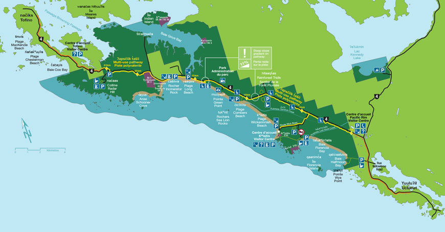
ʔapsčiik t̓ašii is a 25 km multi-use pathway through the Long Beach Unit of Pacific Rim National Park Reserve.
Map of Pathway Route
About the name
Parks Canada is honoured to have Elders from Yuułuʔiłʔatḥ and Tla-o-qui-aht First Nation give the new multi-use path its official name.
ʔapsčiik t̓ašii (pronounced ups-cheek ta-shee) translates to “going in the right direction on the path.” The name has many layers of meaning depending on how the phrase is used.
Individually, it can refer to our personal journeys in life: going in the right direction. To remember we are on the tašii (trail), and going in the right direction refers to being mindful of the environment and all living things.
Collectively, the Elders say “the land we walk on is made from the dust of our ancestors – in our life journey, we walk it carefully, respectfully, with humility and dignity.”
Wayii (meaning hill) is the name the Elders Working Group chose for the escarpment overlooking Long Beach.
Once constructed, the path will also have other Nuu-chah-nulth place names to ensure the cultural significance of the area where the path traverses is acknowledged and appreciated.
Quick facts
- Approximately 25 km long, the path will enhance the regional path network.
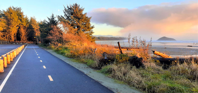
- The path is 3.2 m wide with 1 m wide shoulders, providing room for cyclists and pedestrians to pass safely.
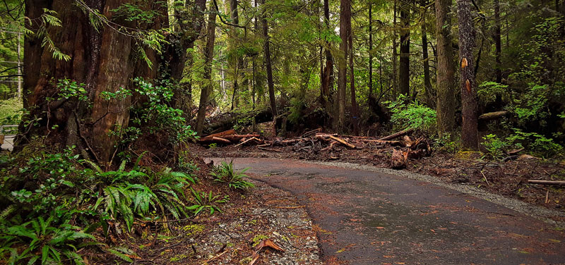
- For the majority of the pathway, this forest experience provides a buffer between people and the road.
- The pathway provides access to new and existing viewpoints and facilities.
- The terrain mainly avoids steep grades (except at the Wayii and the S-curve on Wick Road) and minimizes highway crossings (except two crossings on Wick Road and one on Highway #4 near Radar Hill).
- Parks Canada is using best practices and innovative strategies to minimize environmental and cultural impacts.
- Signage helps visitors discover the wildlife, environment, and Indigenous heritage of the area.
- This project is proceeding in consultation and partnership with the Tla-o-qui-aht First Nations and Yuułuʔiłʔatḥ.
Information sessions
Public information sessions were held in the communities of Tofino, Ucluelet, Yuułuʔiłʔatḥ and Tla-o-qui-aht First Nation in November 2016, June 2017 and March 2019. Click on the links below for more information on what was shared at these sessions:
June 2017
- A delicate balance: inputs, considerations and limitations (PDF, 583 KB)
- Project principles (PDF, 915 KB)
- Path basics: construction, clearing, bridges (PDF, 1.13 MB)
- Project team (PDF, 1.02 MB)
- Path alignment (PDF, 1.95 MB)
- Public feedback (PDF, 503 KB)
- What’s new (PDF, 697 KB)
- What’s next (PDF, 1.12 MB)
March 2019
- Executive Summary
- News Release – Parks Canada makes additional investment in ʔapsčiik t̓ašii multi-use trail in Pacific Rim National Park Reserve to protect the environment and cultural heritage – November 2018
- Backgrounder – Pacific Rim National Park Reserve: ʔapsčiik t̓ašii Multi-use Trail Project – November 2018
- Timeline – Summer 2017 to 2022
- Additional resources
Questions and answers
About ʔapsčiik t̓ašii
Why is Parks Canada building ʔapsčiik t̓ašii?
A pathway through Pacific Rim National Park Reserve has been a long-time request from the local communities and visitors to the area, and will provide Canadians of all ages and abilities a safe, sustainable, and accessible way to experience the national park reserve. This project will also bring short- and long-term financial benefits to the region, and provide a long-term legacy for future generations of Canadians.
What will ʔapsčiik t̓ašii offer visitors and locals?
We all know that getting out of the car and travelling by foot or bike enhances people’s experience of nature immeasurably. Being able to smell the forest, taste the salty air, see rare species, and hear the roar of the ocean is an experience beyond compare. When visitors and locals alike learn about and experience Pacific Rim National Park Reserve using ʔapsčiik t̓ašii, they will also discover reasons to support the long-term protection of Canada’s flora, fauna, and wild spaces inside and outside Canada’s national park system.
When will ʔapsčiik t̓ašii open?
We anticipate ʔapsčiik t̓ašii to be open to the public in 2022. We will have a better sense of when the pathway could be open as the building progresses. As stewards of the land, we are responsible for ensuring the building does not outpace our legal, environmental and social obligations.
The completion date of 2022 allows us to better accommodate for the unique conditions and requirements of building in this location, in a national park reserve. This includes respecting the nesting period for migratory birds, minimizing disruptions to visitors where possible, and working with the challenges presented by wet conditions common in this coastal region.
Additionally, this will allow Parks Canada more time to work with local First Nations within the national park reserve to identify potential short- and long-term economic benefits, and ensure that we are respectful of Treaty rights and asserted Indigenous rights within the national park reserve.
Ensuring the safety of visitors is a priority for Parks Canada. The area will be closed during building, and access will be restricted to contractors and Parks Canada staff.
The region and the national park reserve are already busy in the summer. Does the area need another attraction?
ʔapsčiik t̓ašii will be a year-round attraction, allowing visitors to experience the national park reserve in all seasons. It also promotes a more environmentally friendly, healthy and safe way for people to visit and travel through the national park reserve.
Who is involved in the project?
We are consulting and working in partnership with the Tla-o-qui-aht First Nation and Yuułuʔiłʔatḥ (Ucluelet First Nation) on the planning, development and building of ʔapsčiik t̓ašii. Their support and involvement is integral to the success of this project, and their contributions will ensure the pathway presents a full cultural experience for all national park reserve visitors for years to come.
We have also been speaking with the municipalities of Ucluelet and Tofino, the Alberni Clayoquot Regional District, as well as the local communities, stakeholders and visitors.
Will I have to pay to use ʔapsčiik t̓ašii?
Regular park entry fees apply to all visitors to Pacific Rim National Park Reserve, with no additional fees to use the new pathway.
Fees are charged at most national parks and national historic sites, where revenues are kept to support visitor services and facilities. This means that every time you visit a park or site you are investing in the future of these important places — and in a legacy for future generations.
Will there be an impact on visitors during construction?
We will do our best to minimize any disruptions to visitors and residents, but we do expect there will be some disruptions to visitors and people travelling through the national park reserve while ʔapsčiik t̓ašii is being built. Regular updates on any work that might impact visitors will be posted on Facebook and Twitter.
Building ʔapsčiik t̓ašii
Where will ʔapsčiik t̓ašii go?
ʔapsčiik t̓ašii will be approximately 25 kilometres long and will extend from the southern to the northern boundary of the Long Beach Unit of the national park reserve between Ucluelet and Tofino, with a short loop connecting the Kwisitis Visitor Centre to the highway.
Most of ʔapsčiik t̓aši will be located near the highway, with a forested buffer between pathway users and vehicles to ensure visitor safety, provide a natural feel, take advantage of new and existing facilities, avoid steep climbs or descents, and minimize the number of times the pathway crosses the highway.
How was the route decided upon?
Before the pathway route was planned and designed, a number of studies were conducted, including a Detailed Impact Analysis. In addition, the advice of experts, local First Nations, and Parks Canada staff was sought. Based on this information, we selected a route that has minimal environmental impact, ensures the safety of visitors, and provides an enjoyable experience for users.
The Detailed Impact Analysis has been updated to reflect the latest information, so this document can continue to be a valuable tool as the pathway is built. The Detailed Impact Analysis Addendum is available for the public to view at the Parks Canada Administration building in Pacific Rim National Park Reserve, as well as the districts of Ucluelet and Tofino. An electronic copy can also be requested via email at pc.pacrim.info.pc@canada.ca.
All of this additional information has contributed to design, route decisions, and pathway-building techniques that will balance the goals of minimizing environmental and cultural heritage impacts, ensuring the safety of visitors, and providing visitors with exceptional and meaningful experiences.
What work has been done so far? (Fall 2020)
As of September 2020, the trail bed is now mainly finished. Key projects have been completed during the environmental windows, including the installation of three amphibian highway crossings three clear span bridges, and 63 amphibian pathway crossings.
After environmental, archaeological and geotechnical studies, and a rigorous planning process, the pathway moved from planning to reality in 2017.
Work to clear the pathway began at the north end of the national park reserve, and included the creation of a new parking lot at Radar Hill Road. Between 2017 and 2018, the route from Incinerator Rock at Long Beach to the southern boundary of the national park reserve was cleared, and the felled trees and shrubs were removed.
Parks Canada also worked with engineers, and environmental, archaeological, amphibian, and wetlands specialists. By being flexible and adaptable throughout the pathway-building process, we refined the pathway route and design to help reduce the risk of detrimental impacts to the national park reserve.
All work was and continues to be scheduled around the migratory bird nesting period, and to avoid times when fish are in the streams, and to minimize the impact of the building on our visitors.
What work happens next? (Fall 2020)
In Fall 2020, paving will take place on most of the pathway, however there is more work to be done before ʔapsčiik t̓ašii is open to the public.
The last major section of the pathway we need to build, the Long Beach escarpment, will be built in 2021. Parks Canada is contracting the Tla-o-qui-aht First Nation to clear the small section of forest needed to complete the ʔapsčiik t̓ašii. Work will occur on the west side of Highway 4, north of Green Point Campground. Impacts to visitors are expected to be minimal.
We are working on many final aspects of ʔapsčiik t̓ašii that will ensure a safe and positive visitor experience such as safety signage, line painting, rest stops, crosswalks, and other minor construction projects.
What happened to the trees that were removed from ʔapsčiik t̓ašii?
Parks Canada is guided by the direction, “what is taken from the clearing of ʔapsčiik t̓ašii goes back into ʔapsčiik t̓ašii,” provided by the Elders Working Group. Following this guidance, Parks Canada will use the Cedar trees to build wooden elements on the pathway, and will provide the remainder of the removed trees, and those removed in the future, to the Tla-o-qui-aht First Nation and Yuułuʔiłʔatḥ for use in their communities.
Will ʔapsčiik t̓ašii be paved?
ʔapsčiik t̓ašii is being built with long-term sustainability in mind. Paving the pathway will provide for increase its lifespan, while significantly reducing costs for ongoing maintenance and repairs. A paved pathway will also create opportunities to address the needs and interests of a broader range of park reserve users, including cyclists, people with strollers, and visitors who have limited mobility.
As local municipalities anticipate extending their paths to connect to the multi-use pathway in the national park reserve, paving the portion of the pathway that runs through the park reserve’s boundaries will ensure a seamless connection with those of the local municipalities.
Why is a pedestrian-controlled crosswalk being built at Radar Hill, instead of a pedestrian overpass?
Visitor safety is a priority for Parks Canada. We investigated several options to help visitors cross Highway 4 safely at Radar Hill and determined that an accessible pedestrian overpass is very costly to build and requires ongoing, long-term maintenance.
A pedestrian-controlled crosswalk is a cost-effective style of crossing that is accessible to pedestrians of all abilities, and is built at a point on a busy road that is otherwise unsafe to cross without assistance due to vehicle speed or vehicle numbers.
The new infrastructure is being installed at Radar Hill to enhance pedestrian and motorist safety by providing motorists advanced warning to slow down and stop to allow pedestrians to safely cross the highway.
How can I stay up to date on the building of ʔapsčiik t̓ašii?
We are posting regular updates on Facebook and Twitter as we build ʔapsčiik t̓ašii, as well as this website as needed.
Protecting the environment
How is Parks Canada protecting the environment while the pathway is being built?
Before the pathway was designed and building started, a Detailed Impact Analysis was undertaken to ensure that Parks Canada has a clear understanding of the potential impacts of the project, and to provide a roadmap to address any risks or adverse consequences. The Detailed Impact Analysis comprises a number of environmental, archaeological and visitor safety assessments, and is the baseline document informing this project. As work on the pathway progresses, we are increasing our knowledge about the ecology of the national park reserve, and areas where we need to apply mitigations. We are continually reviewing and revising the information in the Detailed Impact Analysis, in the form of addendums, so that these documents continue to be valuable tools as the pathway is constructed.
What will be done to prevent human-wildlife conflicts on the pathway?
Parks Canada is committed to protecting the wolves, bears, cougars, deer and other wildlife that live in Pacific Rim National Park Reserve, and also to providing visitors with a safe and enjoyable experience.
The design of ʔapsčiik t̓ašii takes into account current best practices to minimize and respond effectively to wildlife encounters on the pathway, including:
- ensuring the route isn’t close to dens or high-use wildlife areas;
- providing clear lines of sight in places where animals might be on the new pathway in order • to give visitors and animals time to react if there is an encounter;
- installing swing gates at entry points to allow immediate safety closures; and
- sharing with visitors safety and prevention practices around wildlife.
In addition, our wildlife specialists are currently studying the pathway to better understand the area as they plan for long-term human-wildlife conflict prevention. As well, they are seeking advice from the Elders Working Group, who are concurrently serving on another working group about managing human-wildlife conflict throughout region.
What is being done to find and protect culturally sensitive areas?
The west coast of Vancouver Island has a long history of human habitation, dating back many thousands of years. We are working with archeologists and the local First Nations communities to conduct studies to test for cultural, resources, both Indigenous and historical. Where a cultural resource is encountered, we will continue to work with the First Nations to assess best steps moving forward, including rerouting of the pathway if required.
How will restoration of the area surrounding ʔapsčiik t̓ašii be managed?
To ensure the long-term sustainability of ʔapsčiik t̓ašii, Parks Canada will investigate options for restoration in greater detail closer to the time when the pathway is completed. As a first step, the successful contractor will be required to restore the disturbed areas along the pathway as work concludes in 2022 and to manage invasive species for two years following the pathway’s completion.
How will garbage be managed on ʔapsčiik t̓ašii?
In the coming months, Parks Canada will work closely with the Tla-o-qui-aht First Nation and Yuułuʔiłʔatḥ, as well as the communities of Ucluelet and Tofino, to develop a Visitor Experience Plan for ʔapsčiik t̓ašii. This plan will include approaches for waste management as well as signage to ensure all aspects of a high-quality visitor experience are considered.
How will visitors be kept from wandering off ʔapsčiik t̓ašii?
To ensure every visitor has a safe and enjoyable visit, Parks Canada will install signage along ʔapsčiik t̓ašii and fencing at Green Point Campground and Esowista. We will also implement a robust restoration plan to help keep visitors on the pathway.
Contact us
Do you have questions, comments or suggestions? Parks Canada invites you to contact us at pc.pacrim.info.pc@canada.ca. We would be pleased to talk to you and provide more information about this project.- Date modified :