
Bulletins
Jasper National Park
Area Closure: Access prohibited - Wildlife corridors
Issued: December 28, 2023
Ends: December 31, 2024
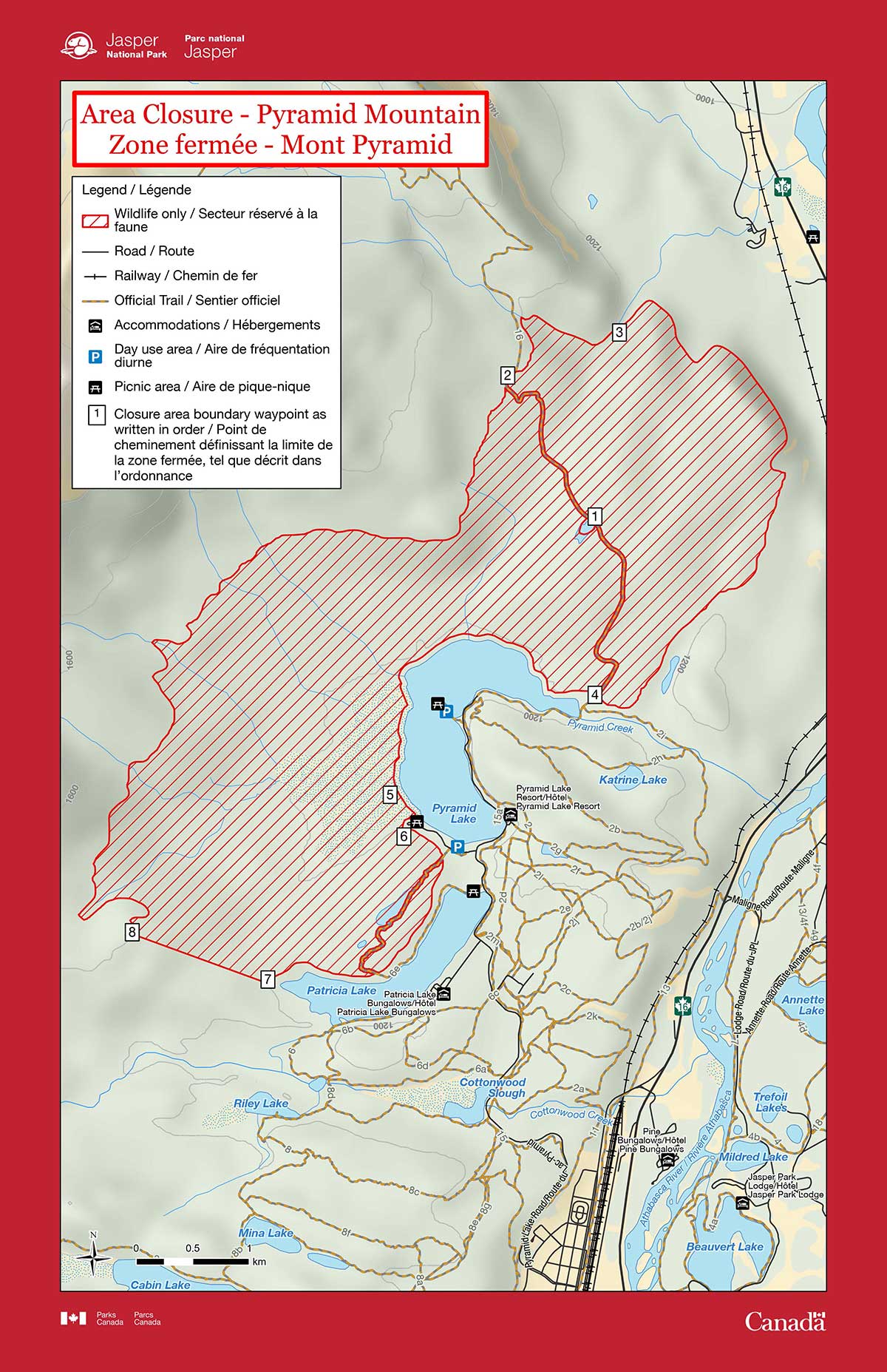
Pyramid Mountain
Effective date
January 1 to December 31What
Pursuant to section 7(1) of the National Parks General Regulations, the following area is prohibited to public use and travel by order of the Superintendent, Jasper National Park.Where
The area between 1200m to 1400m on the slopes of Pyramid Mountain, as delineated in the attached map.
Note: Fifteen metres to either side of the midpoint of trail 16 (Pyramid fire road) and trail 6e, as well as the winter ski trail turn-around meadow, centred at easting 427471 northing 5866102 (#1 on map), are exempt from this area closure.
- Commencing on the slopes of Pyramid Mountain at the unnamed creek at 1400 m elevation band at easting 426883 northing 5867942 (#2 on map) following the creek bed centerline to the 1200 m elevation band at easting 427704 and northing 5867826 (#3 on map).
- Thence continuing southwesterly along the 1200 m elevation band to the northeast corner of Pyramid Lake near the outflow stream and bridge (#4 on map).
- Thence continuing parallel to the North shore of Pyramid Lake at a distance of 50 m from Pyramid Lake's high water line to within 50 m of the day use picnic area at the Southwest corner of Pyramid Lake (#5 on map).
- Thence continuing 50 m from the outside west perimeter of the picnic area and the access road and connecting at the shortest straight line distance to the 1200 m contour at easting 425839 northing 5863415 (#6 on map).
- Thence continuing east and south to the west and north side of Patricia Lake along the 1200 m contour above the north shore of Patricia Lake to the west end of Patricia Lake at easting 424619 northing 5862064 (#7 on map).
- Thence continuing at a bearing of 290 degrees from true north azimuth to the 1400 m contour interval at easting 423461 northing 5862064 (#8 on map).
- Thence following the 1400 m contour interval north-easterly back to the commencement point at easting 426883 northing 5867942 (#2 on map).
Why
To ensure that wildlife are not displaced from an essential travel corridor.
Penalty
Violators may be charged under the Canada National Parks Act: maximum penalty $25 000.
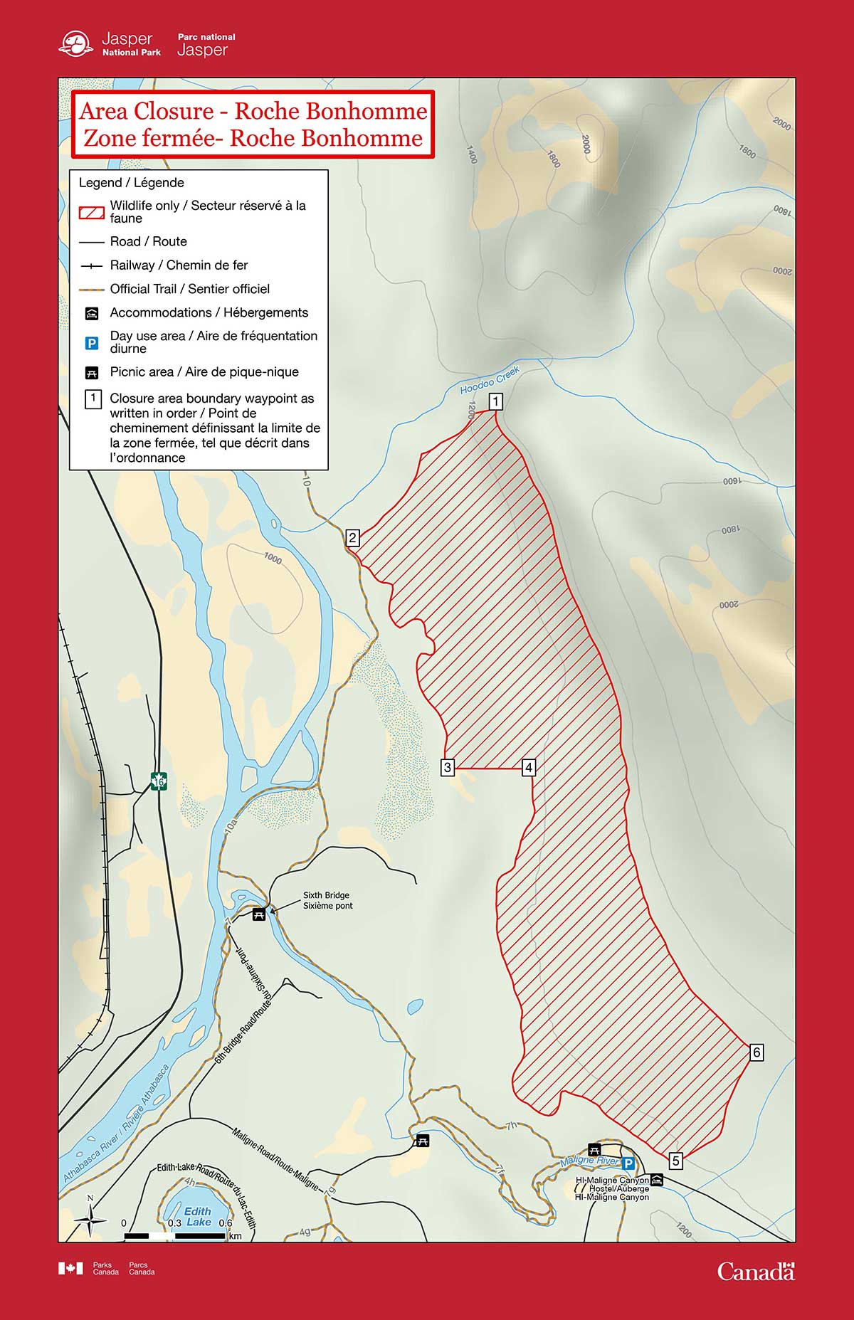
Roche Bonhomme
Effective date
What
Where
The area between 1025 m to 1350 m on the slopes of Roche Bonhomme (Old Man) Mountain, as delineated in the attached map.
Fifteen meters to either side of the midpoint of trail 10 (Overlander trail), 50m around the periphery of the Rock Garden and Boulder Garden climbing areas, and the Old Man Mountain scrambling route access trail starting 375m south of the Maligne Canyon Teahouse are deemed exempt from this area closure.
- Commencing on the slopes of Roche Bonhomme at 1350m elevation 200m south of an unnamed creek at easting 432134 northing 5868307 and proceeding westward paralleling that same creek 200 m to the south downslope to 10 m elevation at easting 431246 northing 5867479 (#1 on map).
- Thence following the 1025m elevation band south to just north of the Parks Canada horse pasture at easting 431833 northing 5866190 (#2 on map).
- Thence at 90 degree from true north bearing up to 1175 m elevation at easting 432324 northing 5866190 (#3 on map).
- Thence south and eastward along the 1175m contour to near the northwest corner of the Maligne Canyon public parking lot, 200m from the unnamed creek that seasonally flows from Roche Bonhomme at easting 433175 northing 5863865 (#4 on map).
- Thence paralleling the unnamed creek on Roche Bonhomme 200m to the northwest upslope to 1350m elevation at easting 433657 northing 5864522 (#5 on map).
- Thence returning along the 1350m elevation band to the commencement point (#6 on map).
Why
To ensure that wildlife are not displaced from an essential travel corridor.
Penalty
Violators may be charged under the Canada National Parks Act: maximum penalty $25 000.
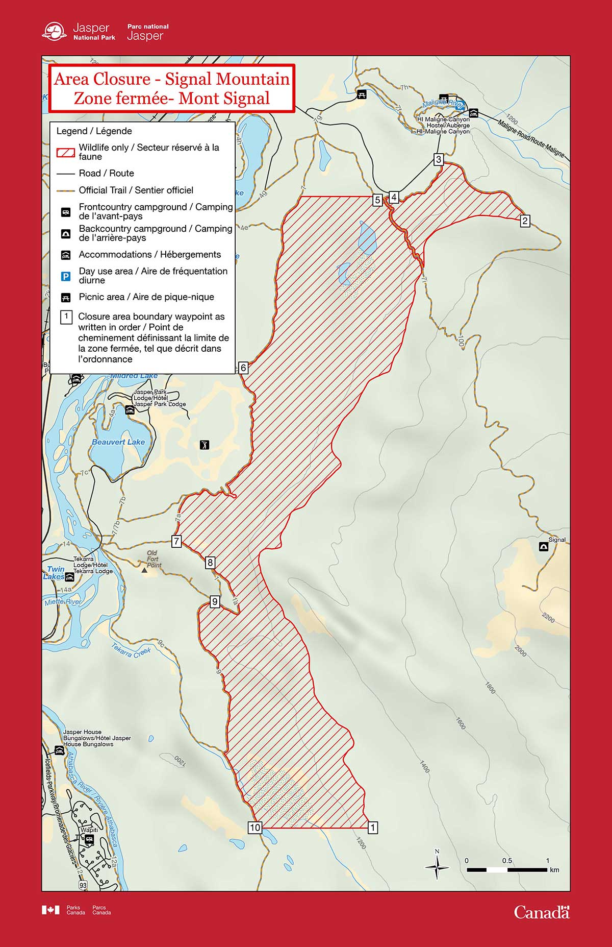
Signal Mountain
Effective date
January 1 to December 31What
Pursuant to section 7(1) of the National Parks General Regulations, the following area is prohibited to public use and travel by order of the Superintendent, Jasper National Park.Where
The lower slopes of Signal Mountain above Lake Edith, the Fairmont Jasper Park Lodge, and Old Fort Point up to an elevation of 1250 m, as delineated in the attached map.
Parks Canada signed and designated trails and 15m to either side of the midline of designated trails are exempt from this travel restriction.
The unsigned access trail and the water reservoir for the Fairmont Jasper Park Lodge above trail 7 with a 15 meter buffer of the trail midline and the water reservoir structure are also exempt from this travel restriction.
- Commencing on the slopes of Signal Mountain at 1250m elevation at easting 431846 northing 5854968 (#1 on map) following the elevation band at 1250m north then east to within 15m of the midpoint of the Signal Mountain fire road on the 1250m elevation line.
- Thence continuing parallel and 15m from the midpoint of the fire road on the left side (#2 on map) (left when descending) of the fire road to the junction with trail 7 (#3 on map).
- Thence continuing 15m from the midpoint of trail 7 on the upslope Signal Mountain side of trail 7 parallel to trail 7 to easting 431903 northing 5862743 (#4 on map).
- Thence a 270 degree from true north bearing to 15m from the midpoint of trail 7 east of Lake Edith at easting 431903 northing 5862743 (#5 on map).
- Thence continuing 15m from the midpoint of trail 7 and paralleling trail 7 to the east and upslope on Signal Mountain as it passes east of the Fairmont Jasper Park Lodge golf course to the junction of trail 7 and 7a (#6 on map).
- Thence continuing parallel and 15m from the midpoint of trail 7a on the east side after trail 7 and 7a junction to the junction of 7a and trail 1(#7 on map).
- Thence continuing 15m from the midpoint of trail 1 paralleling the east side of trail 1 to the junction of trail 1 and trail 1a (#8 on map).
- Thence continuing 15m from the midpoint of trail 1a paralleling trail 1a on the east then south side of trail 1a to the junction of trail 1a and trail 9 (#9 on map).
- Thence continuing 15m from the midpoint of trail 9 south paralleling trail 9 to the east side of trail 9 until just south of Tekarra marsh at easting 430415 northing 5854968 (#10 on map).
Why
To ensure that wildlife are not displaced from an essential travel corridor.
Penalty
Violators may be charged under the Canada National Parks Act: maximum penalty $25 000.
- Date modified :