
Backcountry Ski Huts
Gros Morne National Park
The Gros Morne Cooperating Association, in cooperation with Parks Canada, has established two secluded backcountry ski huts for your winter adventure pleasure. Users of the backcountry huts should be experienced winter wilderness travelers or be guided by experienced wilderness leaders. There are no marked trails or routes that take you right to these huts.
The huts are located in the backcountry far from highways, telephone communication, or medical facilities. It is essential to be properly equipped and prepared for emergencies. Do not underestimate the seriousness of a winter overnight trip. The most common error is leaving the trailhead late in the day.
Use the suggested clothing and equipment list for backcountry skiing to ensure you have all the necessities before you leave.
Disclaimer
There are inherent risks with winter wilderness travel. The areas described herein will at times be unsafe due to weather, snow, ice, and avalanche conditions. Gros Morne National Park has done its best to provide accurate information and to describe the conditions typical of each general area. However, it is up to the users of this information to learn the necessary skills for safe winter travel, access additional trip planning materials, and to exercise caution while travelling in the national park. Users of this information do so entirely at their own risk, and the Parks Canada Agency disclaims any liability for injury, death or damage to anyone undertaking winter travel in any of the regions described. This information is no substitute for experience or good judgement.
Huts and FAQ
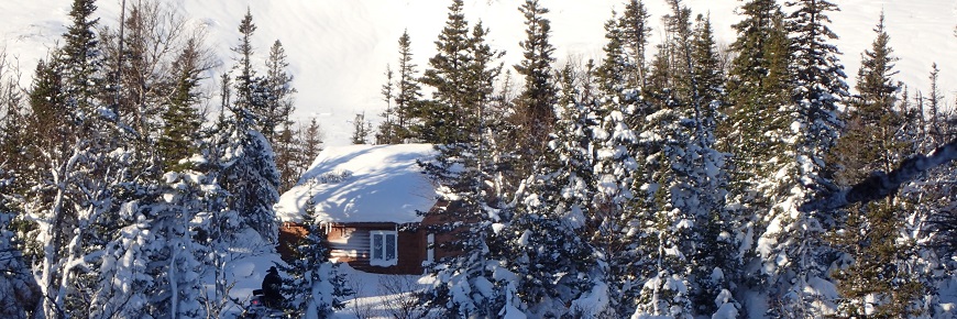
Bakers Brook Hut
Nestled on the wooded shoreline of Bakers Brook Pond Fjord
Located in a sheltered spruce and fir forest beside Bakers Brook Pond, this hut's backdrop is the spectacular mountain scenery of the Long Range. This is an excellent base-camp for further exploration of the gentle terrain of the coastal lowlands and is a recommended backcountry option for the aspiring backcountry skier. For the more experienced and adventurous skiers and snowshoers with appropriate equipment, it is an excellent staging area for exploration of the fjord and the mountains.
The route to the cabin is unmarked but most visitors start on route 430, 5 km north of Rocky Harbour at the access road to the Berry Hill Campground. From there, visitors can follow a combination of unplowed park roads, the Bakers Brook Falls hiking trail, and old pathways to the cabin. The kitchen shelter in the Berry Hill group camping area provides a warm up shelter 2 km in from the highway.
Difficulty: novice - intermediate
Distance: 8.5 km (parking area to hut)
Time: 3-4 hours (one way)
Elevation: 90 m
Hazards specific to this area: Bakers Brook Pond ice, whiteouts, avalanches (in mountainous areas )
Map & Coordinates: Gros Morne 12 H/12, coordonnées UTM E 0437800 N 5499900
Southwest Gulch Hut
A remote backcountry experience and thrilling ski terrain!
Southwest Gulch is located in the Tablelands region, where the terrain ranges from the steep snow-filled bowls to the woods of Crow Mountain in the east. This mountainous region within Gros Morne National Park offers challenging ski terrain, best suited to the skilled, experienced skier and wilderness traveller.
The hut is tucked into the hillside surrounded by tall spruce and fir trees, offering protection from winter winds and a magnificent view of the Tablelands. The suggested routes to and from the hut are steep in sections and require the ability to control speed. If you choose to ski to the top of the Tablelands or to other high points in the area the views of fjords and Bonne Bay are breathtaking and the ski terrain is endless!
There are two suggested routes to this hut. The Tablelands route is a gradual climb over open terrain however it is exposed and should only be attempted in good visibility. The Birchy Head route is more sheltered, however it is a snowmobile route and the trail is narrow and steep in sections.
The ability to identify hazards (including avalanche terrain) and selecting routes best suited to the abilities within your group are essential to completing this trail to the backcountry ski hut.
Difficulty: advanced
Distance: 7- 8 km (depending on route)
Time: 3 - 5 hours (one way)
Elevation: 360 m
Hazards specific to this area: Exposed ski terrain, prone to high winds and whiteout conditions. Avalanche potential.
Map & Coordinates: Lomond 12 H/5, UTM coordinates E 0432300 N 5474600
Frequently Asked Questions
How do I book? Call the Gros Morne Co-op at (709) 458-3605/3610 or email darlene@gmist.ca. A credit card is required to make a booking. If your plans change, cancelling at least one week prior to your trip departure date will ensure a 100% refund.
- The season for backcountry skiing is from January to April, depending on snow conditions.
- Huts accommodate a minimum booking of 2 people and a maximum of 10 people. (This is enforced due to insurance regulations, exceeding 10 people will be subject to $500.00 fine)
What does it cost? $30 per person, per night or $180 for exclusive use, regardless of the number.
What are the huts facilities and services? Each hut is two storey, approximately 90 square metres with a sleeping loft upstairs. Lighting and stoves are provided and use propane which is supplied. There is 1 propane stove with 4 burners and an oven.
What is provided within the kitchen? Sink with drain, tables, benches, cutlery, dishes and pots to accommodate 10 people.
Heat source? Wood stove with axe and wood supplied
Water source? There is snow nearby and/or brook in walking distance (must boil for drinking).
Toilet facilities? Baker’s Brook – indoor flush toilet with septic field - Southwest Gulch – indoor flush toilet with septic field
Related links
- Date modified :