
Upper Brewers Lockstation
| < Jones Falls Lockstation | Lower Brewers Lockstation > |
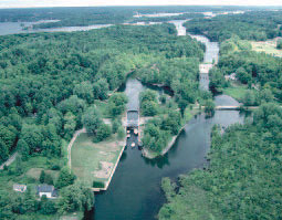 Upper Brewers Mills Lockstation is set in an excavated channel with the river passing to the right. A powerhouse (upper right) occupies the site of the original mills. © Parks Canada |
176,3 km – 176,7 km
This lockstation is located along a 400-m excavated channel and a man-made basin. Earth embankment dams hold back the water in the excavated channel from the river that passes nearby. The locks are at the southern end of the excavated channel. A weir crosses the river at the entrance to the excavated channel, creating a slackwater section extending north to Jones Falls.
Two locks – Two manually operated locks in flight with a combined lift of 5,3 m, 1830. CRM1.
Earth embankment dams – A dam on the east side of lock, 122 m long and 3 m high, 1830. CRM1. A shorter dam is on the west side of the lock, 1830. CRM1.
Defensible lockmaster’s house – A one-storey stone building, 1840. CRM1.
Canalman’s house – A frame one-and-a-half-storey house, 1897. CRM2
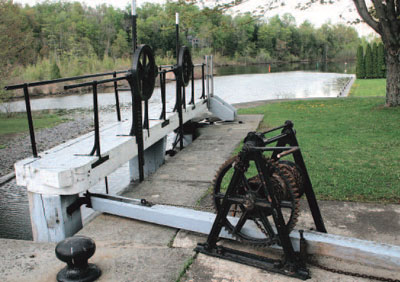 Winch and push bar mechanism, the most common operating system, is used for controlling the lower gates. © Parks Canada |
Upper Brewers Lockstation to Lower Brewers Lockstation
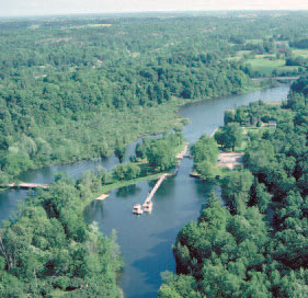 After Upper Brewers, the navigation channel follows the course of the Cataraqui River (top), enlarged by the dam a Lower Brewers Mills. © Parks Canada |
176,7 km – 179,3 km
A 2,6-km slackwater enlargement of the original course of the Cataraqui River, created by the construction of the earthen dam at Lower Brewers Lockstation.
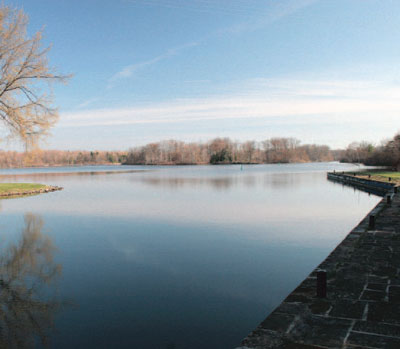 View from the upper wharf at Lower Brewers looking across the small slackwater lake. © Parks Canada |
| < Jones Falls Lockstation | Lower Brewers Lockstation > |
Related links
- Ottawa Lockstation
- Hartwells Lockstation
- Hogs Back Lockstation
- Black Rapids Lockstation
- Long Island Lockstation
- Burritts Rapids Lockstation
- Nicholsons Lockstation
- Clowes Lockstation
- Merrickville Lockstation
- Kilmarnock Lockstation
- Edmonds Lockstation
- Old Slys Lockstation
- Smiths Falls Combined Lockstation
- Smiths Falls Detached Lockstation
- Poonamalie Lockstation
- Beveridges Lockstation, Tay Canal
- Perth, Tay Canal
- The Narrows Lockstation
- Newboro Lockstation
- Chaffeys Lockstation
- Davis Lockstation
- Jones Falls Lockstation
- Lower Brewers Lockstation
- Kingston Mills Lockstation
- Date modified :