
Chapter 1 - Identification of the Property
![]() PDF Version (33,183 KB)
PDF Version (33,183 KB)
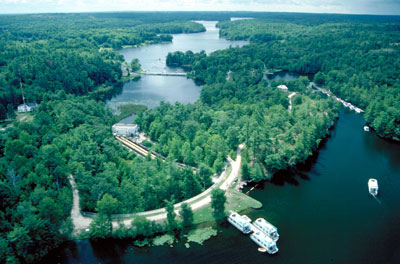 Rideau Canal. © Parks Canada |
- Country/State Party
- State, Province, or Region
- Name of property
- Geographical coordinates to the nearest second
- Maps and plans, showing the boundaries of the nominated property and buffer zone
- Area of the nominated property (ha) and proposed buffer zone (ha)
A. Country/State Party
Canada
B. State, Province, or Region
Province of Ontario
C. Name of property
The Rideau Canal
The nominated property consists of the engineering works, associated fortifications, buildings, lockstation grounds and their archaeological resources, and the watercourse of the slackwater canal system.
D. Geographical Coordinates to the nearest second
The northern entrance to the canal at Ottawa, on the Ottawa River, is located at 75° 42' west longitude and 45° 26' north latitude. The southern entrance at Kingston, at Lake Ontario, is located at 76° 28' west longitude, and 44° 14' north latitude. The coordinates for the six elements of the property are listed on the Serial Nomination Table.
E. Maps and plans, showing the boundaries of the nominated property and buffer zone
Map 1 shows the entire nominated property at the scale of 1:657 296.
Map 2 shows the location of the Rideau Canal within the State Party at the scale of 1:27 718 254.
Map Series 3.0 to 3.57, located in the Map Annex, shows the nominated property and buffer zone at a scale of 1:20 000.
Map Series 4.0 to 4.24, located in the Map Annex, shows the lockstations at a scale of 1:4 800.
Map 5, located in the Map Annex, shows the fortifications at a scale of 1:12 600.
F. Area of nominated property and proposed buffer zone
Area of nominated property: 21 454.81 ha
Buffer Zone: 2 363.20 ha
Total: 23 818.01 ha
Serial Nomination Table
| Element NO | Name of Element | Area (ha) | Buffer (ha) | Geographic Coordinates | Map Number | |
|---|---|---|---|---|---|---|
| 01 | Rideau Canal | 21427.07 | 2334.78 | From N45 20 21.31 (Ottawa Lockstation) to N44 15 52 49 (Lake Ontario) | W75 42 6.11 | 1 2 3.1-3.57 4.1-4.24 |
| 02 | Fort Henry, Kingston | 23.90 | 11.88 | N44 13 51.41 | W76 28 00.46 | 5 |
| 03 | Fort Frederick, Kingston | 3.10 | 3.00 | N44 13 40.64 | W76 27 35.70 | 5 |
| 04 | Cathcart Tower, Cedar Island | 0.25 | 9.15 | N44 13 30.04 | W76 27 27.93 | 5 |
| 05 | Shoal Tower, Kingston | 0.32 | 1.68 | N44 13 45.88 | W76 28 44.90 | 5 |
| 06 | Murney Tower, Kingston | 0.17 | 2.71 | N44 13 19. 71 | W76 29 25 22 | 5 |
| TOTAL | 21454.81 | 2363.20 | ||||
Map 1 – Rideau Canal - Nominated Property
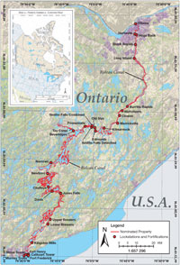 Rideau Canal - Nominated Property Click here to view a larger version of this map (127 Kb). © Parks Canada |
Map 2 – North America - Context Map
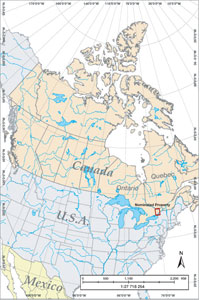 North America - Context Map Click here to view a larger version of this map (130 Kb). © Parks Canada |
Related links
- Rideau Canal: World Heritage nomination
- Chapter 2 - Description
- Chapter 3 - Justification for Inscription
- Chapter 4 - State of Conservation and Factors Affecting the...
- Chapter 5 - Protection and Management of the Property
- Chapter 6: Monitoring
- Chapter 8 - Contact Information of Responsible Authorities
- Chapter 9 - Signature on Behalf of the State Party
- PDF version
- Table of contents
- Date modified :