Dawson Historical Complex National Historic Site of Canada
Dawson, Yukon Territory
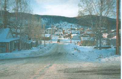
General view of the place
© Agence Parcs Canada / Parks Canada Agency, Gordon Fulton, 1999.
Address :
Third Avenue, Dawson, Yukon Territory
Recognition Statute:
Historic Sites and Monuments Act (R.S.C., 1985, c. H-4)
Designation Date:
1959-05-25
Dates:
-
1896 to 1910
(Construction)
Event, Person, Organization:
-
Klondike Gold Rush
(Event)
Other Name(s):
-
Dawson Historical Complex
(Designation Name)
Research Report Number:
1987-A05; 1967-17; 1967-16; 1963-04
Plaque(s)
Existing plaque: Entrance to the Palace Grand Theatre Third Avenue, Dawson, Yukon Territory
While others sped to the gold laden creeks, Joe Ladue put his faith in real estate and claimed this flat. In 1897 William Ogilvie, D.L.S., surveyed Joe's Townsite and his claim was recognized. By late 1898 Dawson was seething with 30,000 optimists who had come to seek the substance of their dreams in the surrounding hills and creeks. Within three years, though a handful had won fortunes from the muck, large mining companies held most of the rich ground, and at least 20,000 stampeders had departed in quest of other Eldorados. Until 1953 Dawson was the capital of the Yukon Territory.
Description of Historic Place
The Dawson Historical complex comprises the core of Dawson City, Yukon, a town established during the Klondike Gold Rush on a flat of land at the confluence of the Yukon and Klondike Rivers in a vast, rugged, northern landscape. Most buildings reflect pioneer, boom-town architecture in their small scale, simple massing and wood construction. The designation refers specifically to the 18 individually identified buildings and their sites and settings within the townsite.
Heritage Value
Dawson Historical Complex was designated a national historic site of Canada for its association with the full extent (1896-1910) and impact of the Klondike Gold Rush.
The heritage value of Dawson Historic Complex National Historic Site of Canada is embodied in its evocation of the time and place of the Klondike Gold Rush, which is conveyed by the surviving natural and built landscape features. Of particular value are the outlines of the original townsite survey, and the wide range and occasional concentration of frontier structures, which confirm the town’s early nature, diversity, northern isolation, and links to mining activity during the 1896-1910 period. Since the 1960s, Parks Canada has conserved and presented many of the buildings in the town, laying the foundation for its re-incarnation as a tourism venue.
Sources: Historic Sites and Monuments Board of Canada, Minutes, November 1959;
Commemorative Integrity Statement, September 1997.
Character-Defining Elements
Key elements which contribute to the heritage value of this site include: the setting on a flat of land bounded by the Klondike and Yukon rivers and bordered by hills; the grid street layout of the 1897-98 survey plot; townscape features of the 1896-1910 era including the orientation of lot lines and buildings, and the spatial relationship of built groupings of similar form, age and /or function within the townsite; the prevalence of boomtown facades, rough-and-ready (log, wood, metal and brick) finishing materials, and vernacular construction techniques, ad hoc additions, eclectic mix of Victorian and Edwardian components on buildings; early government buildings identified by the HSMBC, their distinctive forms, wood finishing materials, platform frame construction, and siting both as a government complex and distributed among other structures on the townsite (the Commissioner’s Residence, Old Post Office, Former Territorial Court House, Northwest Mounted Police Married Quarters, Old Territorial Administration Building); existing frontier buildings identified by the HSMBC in their original form, massing and materials (Daily News Building, Robert Service Cabin, Ruby’s Place, Caley’s Store, Klondike Thawing Machine Company, Billy Biggs’ Blacksmith Shop, Carnegie Library/Masonic Temple, Bank of British North America, Canadian Bank of Commerce, St. Paul’s Anglican Church, Yukon Hotel); landscape vestiges of the 1896-1910 era such as open public spaces, side and back yards, unpaved streets and boardwalks, railways; evidence of permafrost and the northern climate in shaping the town’s landscape; viewplanes from the flat of land that comprises the townsite to its defining natural features: the Klondike and Yukon Rivers, the Midnight Dome and surrounding hills, the Moosehide Slide.