Chambly Canal National Historic Site of Canada
Chambly, Quebec
original HSMBC 1927 plaque
(© Parks Canada Agency / Agence Parcs Canada, 2002.)
Address :
Corner of Bourgogne and Maurice, Chambly, Quebec
Recognition Statute:
Historic Sites and Monuments Act (R.S.C., 1985, c. H-4)
Designation Date:
1929-05-17
Dates:
-
1831 to 1843
(Construction)
-
1848 to 1860
(Significant)
-
1868 to 1880
(Significant)
-
1880 to 1895
(Significant)
-
1977 to 1980
(Significant)
-
1990 to 1990
(Significant)
Event, Person, Organization:
-
William R. Hopkins
(Architect)
Other Name(s):
-
Chambly Canal
(Designation Name)
Research Report Number:
1988-SUA; 1987-A03-4
DFRP Number:
06688 00
Plaque(s)
Approved Inscription: Corner of Bourgogne and Maurice Chambly, Quebec
The Chambly Canal, built between 1835 and 1843, was initially promoted to capture the trade of Vermont for the St. Lawrence River. Its 12-mile waterway from Saint-Jean to Chambly, along with the Saint-Ours Canal, made the Richelieu River navigable from Lake Champlain to the St. Lawrence. By 1850 it was moving Ottawa Valley lumber to the New York market and Pennsylvania coal to Montréal. Shipping on the canal reached its peak between 1909 and 1912, and thereafter slowly declined. By the early 1970s trade had given way entirely to leisure boating.
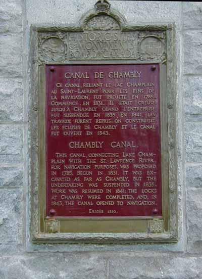
Existing plaque: Corner of Bourgogne and Maurice Corner of Bourgogne and Maurice, Chambly, Quebec
The Canal, connecting Lake Champlain with the St. Lawrence River, for navigation purposes, was proposed in 1785. Begun in 1831, it was excavated as far as Chambly, but the undertaking was suspended in 1835. Work was resumed in 1841; the locks at Chambly were completed, and, in 1843, the canal opened to navigation.
Description of Historic Place
Chambly Canal National Historic Site of Canada is located on the west bank of the Richelieu River, south-east of Montréal, Quebec. Twenty kilometres long, the Chambly Canal is a section of a waterway constructed in the 19th century between Chambly and Saint-Jean-sur-Richelieu on Québec’s Richelieu River. The canal constitutes part of an inland water transportation route joining Montréal and New York City. The site includes the waterway itself, nine locks, five weirs, two piers, dams, dikes and bridges, and several other elements and buildings associated with the operation of the canal. Official recognition refers to the legal property of Parks Canada Agency.
Heritage Value
Chambly Canal was designated a national historic site of Canada in 1929 because: it is part of Canada's National Canal System.
The heritage value of Chambly Canal lies in the longstanding interrelationship between the composite parts of the canal’s cultural landscape, namely the Richelieu River, the canal route, the dam on Fryer Island, and the buildings. The Chambly Canal was originally constructed to bypass the Chambly Rapids on the Richelieu River. Designed by engineer William R. Hopkins, it constituted eleven kilometres of canal built against one river bank with a berm or embankment to maintain the raised water, and an eight-kilometre cut parallel to the river. Built in 1831-1843 as a commercial route, it was altered in 1848-60, 1869-1880, and 1880-1895, and restored by Parks Canada for recreational use in 1977-1980 and 1990.
Source: Historic Sites and Monuments Board of Canada, Minutes, November 1988, June 1994.
Character-Defining Elements
Key elements that contribute to the heritage character of the site include: its location on the west bank of the Richelieu River, south-east of Montréal, Quebec; the forms and features of the canal itself which govern the cultural landscape, including its route, its footprint, its width or breadth, its banks, its jetties and its wharfs; and viewscapes to 19th and early 20th century economic development along the banks of the canal associated with the time when this was a commercial transportation route.
Key components of the present canal that testify to the material and engineering technologies that have created and maintained it over time, including: the new locks that mark the canal route between Chambly and Saint-Jean-sur-Richelieu; the steep lower entry to the canal at Chambly; the lock chamber spaces that punctuate the canal route; the dam that connects the waterway to the river at Fryer Island; and the movable bridges that link the two waterways of the canal.
Key components of the cultural landscape of the present canal that provide tangible evidence of the historical use and evolution of the canal site over time, including: the freight road running alongside the canal on the east bank; the service road running alongside the canal on the west bank; and the many buildings associated with the operation of the canal, and in particular the old lockmaster’s house adjacent to three lock levels on the lower entry to the canal at Chambly.