Fort Frontenac National Historic Site of Canada
Kingston, Ontario
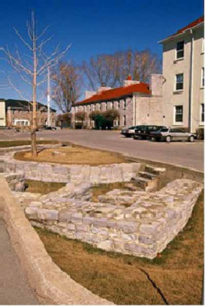
General view
(© Parks Canada Agency / Agence Parcs Canada, J. Butterill, 1995.)
Address :
1 Ontario Street, Kingston, Ontario
Recognition Statute:
Historic Sites and Monuments Act (R.S.C., 1985, c. H-4)
Designation Date:
1923-05-25
Dates:
-
1673 to 1673
(Construction)
-
1675 to 1675
(Significant)
-
1695 to 1695
(Significant)
-
1673 to 1832
(Significant)
-
1937 to 1937
(Significant)
-
1982 to 1982
(Significant)
Event, Person, Organization:
-
Colonel John Bradstreet
(Person)
-
Louis de Buade Comte de Frontenac
(Architect)
-
René-Robert Cavelier de La Salle
(Architect)
Other Name(s):
-
Fort Frontenac
(Designation Name)
-
Fort Cataraqui
(Other Name)
-
Canadian Land Forces Command and Staff College
(Other Name)
Research Report Number:
2008-SDC/CED-005
DFRP Number:
09445 00
Plaque(s)
Existing plaque: 1 Ontario Street, Kingston, Ontario
Here stood Fort Cataraqui or Frontenac built by Count de Frontenac in July, 1673, and rebuilt by La Salle in 1675. For many years the key to the West, the base of La Salle's explorations and a French outpost against the Iroquois and English.
Abandoned 1689, rebuilt 1696, captured by British troops under Colonel John Bradstreet, 27th August, 1758.
Description of Historic Place
Fort Frontenac National Historic Site of Canada is an archaeological site located beneath the intersection of Ontario Street and Place D’Armes in Kingston, Ontario. The site extends under four stone buildings, constructed during the 1820s as part of the former Tête du Pont Barracks on the southern portion of ground previously occupied by the original French fort. While these four buildings are part of a complex currently referred to as Fort Frontenac, only a fragment of the original fort can be seen today. Sections of the west and north limestone curtain walls are exposed on a traffic island at the intersection of Ontario Street and Place D’Armes. Official recognition refers to the footprint of Fort Frontenac.
Heritage Value
Fort Frontenac was designated a national historic site of Canada in 1923. It is recognized because: built in 1673 by the Comte de Frontenac and rebuilt in 1675 and 1695, it was, for many years, the key to the West, the base of LaSalle’s explorations and a French outpost against the Iroquois and English; Indigenous Peoples, their territories, and labour were foundational to the fur trade in North America. Posts were often built near existing Indigenous settlements, trading routes and/or meeting places and became important sites of economic, social and cultural exchange.
Fort Frontenac, located at the confluence of the Cataraqui River and Lake Ontario, was established in 1673 by the Governor of New France, the Comte de Frontenac, in order to control access to the fur laden lands of the Great Lakes Basin and the Canadian Shield. As the fur trade expanded west along the Great Lakes and into the Mississippi and Ohio River valleys, the explorer René-Robert Cavelier de La Salle rebuilt the wooden fort into a stronger masonry building by reinforcing it with limestone walls and square bastions. The fort became a strong French outpost against the British and the Iroquois, as several smaller buildings were built around it and a community of settlers established themselves in the region. During one of La Salle’s extended explorations of the interior in 1682, the fort fell into the hands of creditors who neglected its defences and, after an attack by the Iroquois, the French ordered the fort’s destruction in 1689. However, in 1695, the Comte de Frontenac ordered the fort rebuilt, and it was occupied by a small garrison until 1745. In 1758, the British under Colonel John Bradstreet captured the fort and it remained in British possession until the end of the War of 1812, when it was deemed obsolete and was gradually demolished. Archaeological research in 1982 uncovered several sections of antiquated limestone walls constructed by La Salle, including those sections of the north and west curtain walls that remain visible today.
Sources: Historic Sites and Monuments Board of Canada, Minutes, 1925; 2008; December 2020.
Character-Defining Elements
The key elements that contribute to the heritage character of this site include: its location at the confluence of the Cataraqui River and Lake Ontario, which made it a geographically strategic French outpost for the fur trade and base for La Salle’s explorations; its footprint in relation to the former Tête du Pont Barracks and the surrounding city streets; the visibility of sections of the north curtain wall and the west curtain wall, in a traffic circle at the intersection of Ontario Street and Place D’Armes; the remains of the various phases of the fort, in their location, extent and materials, both discovered and undiscovered; all archaeological remains, both underground, undiscovered and discovered that relate to Fort Frontenac.