Signal Hill National Historic Site of Canada
St. John's, Newfoundland and Labrador
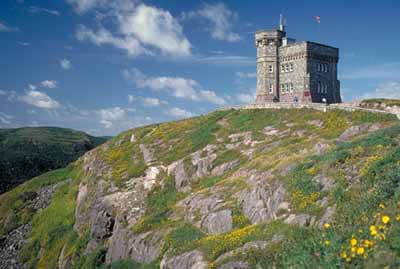
General view
© Parks Canada Agency/Agence Parcs Canada, F. Bergeson, NFPO Collection/011.
Address :
230 Signal Hill Road, St. John's, Newfoundland and Labrador
Recognition Statute:
Historic Sites and Monuments Act (R.S.C., 1985, c. H-4)
Designation Date:
1951-05-30
Dates:
-
1697 to 1697
(Construction)
-
1914 to 1919
(Significant)
-
1939 to 1945
(Significant)
-
1660 to 1697
(Significant)
-
1697 to 1870
(Significant)
-
1762 to 1762
(Significant)
-
1901 to 1901
(Significant)
Event, Person, Organization:
-
Battle of Signal Hill
(Event)
-
Guglielmo Marconi
(Person)
-
Lieutenant Colonel William Amherst
(Person)
-
Canadian Marconi Co.
(Organization)
-
Transport Canada
(Organization)
-
British Army
(Organization)
-
Captain Robert Pringle, R.E
(Builder)
Other Name(s):
-
Signal Hill
(Designation Name)
-
Battle of Signal
(Plaque name)
-
Cabot Tower, Noone Room, South Castle, Frederick Battery, Fort Amherst
(Name of contributing resources)
Research Report Number:
1998-010, 1998-028
DFRP Number:
00394 00
Plaque(s)
Existing plaque: 230 Signal Hill Road, St. John's
With commanding views of the Atlantic, for three centuries Signal Hill was important for defence and communications. Shore batteries built in the 17th century gave way to substantial fortifications on the summit as France and Great Britain battled for control of the continent. Between the departure of the British military in 1870 and the arrival of American and Canadian forces during the Second World War, the Hill remained an active flag signalling and communication post. In 1901, Guglielmo Marconi received the first transatlantic wireless transmission atop Signal Hill, a landmark achievement in global communications history.
Description of Historic Place
Signal Hill National Historic Site of Canada, located at the northeastern end of St. John’s harbour, is composed of two cultural landscapes – Signal Hill itself and the south side of the Narrows. Signal Hill is the steep hill that frames the entrance on the north side of St. John’s Harbour from St. John’s Bay. Identifiable by the castellated profile of Cabot Tower, Signal Hill descends gently in ridges and valleys towards St. John's to the west and Quidi Vidi waterway to the north. Across the Narrows, a ribbon of land at the base of the steep Southside Hills contains several fortification and communication sites including Noone Room, South Castle, Frederick’s Battery and Fort Amherst National Historic Site of Canada. Today the historic place of Noone Room and its mooring area known as Ring Noone are buried beneath an industrial marine boat basin built in the 1980s.
Heritage Value
Signal Hill was designated a national historic site of Canada because it is importantly associated with Canada’s defence and communications history. The heritage value of Signal Hill lies in the historical associations of both sides of the Narrows as illustrated by the physical resources of the two cultural landscapes, including their locations, settings, natural and built resources, particularly evidence of defence and communications activities.
Signal Hill has been a military site since the 17th century, but most importantly during the four periods 1660-1697, 1697-1870, World War I, and World War II. Today it contains a broad range of military and civilian resources, among them works on the south side of the harbour narrows, notably the remains of Fort Amherst, a British fortification completed by Captain Robert Pringle, R.E. in 1777 to guard the entrance to the Narrows. Fort Amherst was also declared a national historic site of Canada in 1951. The hill was also the site of the Battle of Signal Hill (15 September 1762) when Lieutenant Colonel William Amherst led an expeditionary force to recapture St. John’s from the French, itself an event of national significance.
The history of signaling on Signal Hill embodies the fundamentally modern transition from visual signals to wireless ones. Signal Hill is the site of the Cabot Tower, built between 1898 and 1900 to continue the port signaling service which originated in 1704; flag signaling continued from the deck of Cabot Tower until 1958. On 12 December 1901 Guglielmo Marconi received the first transoceanic wireless signal in a former military barracks on Signal Hill. From 1933 to 1949 the Canadian Marconi Co. operated a wireless station on the second floor of Cabot Tower; from 1949 until 1960, the Canadian Department of Transport operated the station.
Sources: Historic Sites and Monuments Board of Canada, Minutes, May 1953, May 1998; Commemorative Integrity Statement, December 2001.
Character-Defining Elements
Key elements that contribute to the heritage character of the site include: the location on either side of the harbour entrance to St. John’s; the north-south alignment along the harbour entrance; the 106-hectare Signal Hill landscape with its steep seaside cliffs and gentler landward descent, valleys, ponds, ridges and peaks; the narrow strip of land at the base of the steep Southside Hills with its remnant fortification and communication sites; the headlands, coves, and rock outcrops in the Narrows and along the coast; pathways and viewsheds between and among the resources of these two cultural landscapes; the Cabot Tower in its location on the peak of signal Hill, with its square two-storey, flat-roofed massing and octagonal three-storey tower, its regular fenestration, Gothic Revival forms such as the tower, crenelation, contrasting stone bands, corner buttresses, and parapet, its masonry construction using large blocks of irregularly coursed red sandstone, evidence of original functional layout as a communications (signals) structure, and its site on the tip of the Signal Hill ridge; the footprint, massing and as-found form of the historic structures including the Imperial Powder Magazine (ca.1798), the Quonset hut (ca.1941), Second World War Magazine (ca.1940-45), portions of Queen’s Battery Barracks (ca.1832) and Queen’s Battery Gun Positions (ca.1796), Chain Rock Battery (ca.1941), Fort Amherst gun and searchlight emplacements (ca.1940-45), and Fort Amherst Lightower (ca.1954); the design, construction technique and materials, layout and orientation of the historic structures as it reflects a specific period (late 18th century, early 19th century, early 20th century, World War II, post war) and type of military and domestic architecture, in particular the excellent craftsmanship of the Imperial Powder Magazine; archaeological evidence of earlier structures on the sites of these buildings, specifically those on the site of the Fort Amherst Lightower; the integrity of archaeological sites situated on both sides of the Narrows, above and below ground, including those not investigated and those investigated, specifically Chain Rock Battery, remnants of military structures on the summit ridge, at Ladies’ Lookout, at Queen’s Battery, in the Artificer’s Yard, remains of the Blockhouse and George’s Barracks, remains at Gibbet Hill, Ross’s Valley, Cuckold Cove and Carronade Hill on Parks Canada property as well as those of Fort Amherst, Frederick’s Battery, South Castle, and unidentified 19th-century military structures on the south side of the Narrows, in their locations, orientations, footprints and profiles, their layout, composition, remnant materials and workmanship; the Fort Amherst light tower in its siting, design, materials, craftsmanship and equipment; the material integrity of historic moveable objects, specifically the 4.7 inch (11.9 cm) quick firing gun found at Chain Rock Battery, a Hotchkiss gun and 9 pounder rifled muzzle-loader cannon administered by Parks Canada, and two 4.7 inch (11.9 cm) quick firing guns located inside the Fort Amherst Second World War Battery outside Parks Canada’s control; viewscapes from the south side to Chain Rock Battery on the north shoreline, from Signal Hill to St. John’s, Quidi Vidi, St. John’s Harbour, St. John’s Bay and along the coastline to Cape Spear.