Cobalt Mining District National Historic Site of Canada
Cobalt, Ontario
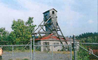
Mining Building
© Andrew Waldron, Agence Parks Canada Agency, 2001.
Address :
Cobalt, Ontario
Recognition Statute:
Historic Sites and Monuments Act (R.S.C., 1985, c. H-4)
Designation Date:
2002-07-18
Dates:
-
1903 to 1920
(Established)
Other Name(s):
-
Cobalt Mining District
(Designation Name)
Research Report Number:
2001-35
Plaque(s)
Existing plaque: Cobalt, Ontario
Cobalt played a decisive role in the evolution of hard-rock mining in Canada. Between 1903 and the 1920s, the district's rich veins triggered a mining boom which attracted international attention and led to Cobalt's emergence as the silver capital of the world. The history of this industry is written in the surrounding landscape. Open-cuts carved from the rock by hand reflect the earliest surface mining operations. Mining shafts, sunk as operations expanded, are marked by the presence of headframes. Concrete foundations, massive rockpiles and remnants of tailings indicate the location of milling facilities for processing ore on site. Cobalt's former prosperity is still visible in the substantial commercial and financial buildings dominating the town centre. Ultimately, the operations at Cobalt established a cadre of mining professionals and a pool of capital, which sparked further mining exploration and proved invaluable in the development of large-scale gold and copper mining in Ontario and Quebec.
Description of Historic Place
The Cobalt Mining District National Historic Site of Canada consists of portions of the Town of Cobalt and a part of the Township of Coleman in the District of Timiskaming, which contain landscape features, mines and buildings associated with early 20th-century silver mining and urban settlement.
Heritage Value
The Cobalt Mining District was designated a national historic site of Canada because: it is a rare cultural landscape consisting of vestiges and buildings associated with the evolution of hard rock mining in Canada; and it reflects an important period of hard rock mining in Canada, between 1903 and the late 1920s, that established a more secure investment environment for mining speculation and created financial capital for large-scale Canadian mining development in the first half of the 20th century.
Source: Historic Sites and Monuments Board of Canada, Minutes November 2001; Commemorative Integrity Statement
Character-Defining Elements
Key elements of the site directly related to the heritage value include: the cultural landscape comprised of two distinct areas, the pre-1930 mine and milling sites and the pre-1930 townsite; the geological setting with its numerous veins of native silver located amid a rolling topography of the glaciated Canadian Shield with its abundant lakes; the principal mine and milling sites from the pre-1930 era, including some nine headframes, capped mine shafts with shaft houses, open cuts, adits, tailings, waste rock piles, roads, trails, vestiges of compressed air pipelines, systematic trenching, deforestation, overburden removal, and footing of aerial tramways, four lake beds partly filled with tailings and the completely filled Cart Lake; the distribution of mining features throughout the landscape related to the location of silver deposits; the large number of small-scale operations resulting from the 20-acre and 40-acre claim limits; the location of former milling and processing plants on hillsides to allow for gravity feed; surviving vestiges, including right-of-way, raised bed, rock cuts, and station related to the former Kerr Lake streetcar line; the vestige of the Ragged Chute Compressed Air Pipeline including exposed pipe sections, concrete anchors, valve shack, visible right-of-way, and surviving booster station; surviving in-situ mining-related machinery in its materials, form and location; the unplanned, frontier character of the pre-1930 townsite of Cobalt with its commercial buildings clustered near the railway station at the intersection of Prospect and Silver streets, its residential area with its mix of housing types ranging along narrow streets and laneways, and its three former mine sites; the relatively dense concentration of buildings in the original commercial core; the location and route of the Timiskaming and Northern Ontario Railway line; the distinctive mining architecture, notably the form and timber-frame ,wood and corrugated sheet-metal materials of the rockhouses, headframes, and support buildings; the pre-1930 commercial and financial buildings in their location, form and materials, notably the poured-in-place concrete three-storey former Royal Exchange Building, the prefabricated form and materials of the former Imperial Bank of Canada building (now Township of Coleman Office), and the T&NO Railway Station; the pre-1930s residences in their location, form and materials, including two mine managers' and four miners' houses in town and houses at mine sites including the O'Brien Mine Manager's House and three houses at Kerr Lake; pre-1930s examples of pre-fabricated housing in their location, form and materials; the location, materials and extent of mining-related archaeological sites; the underground mining works, notably the network of excavations under the district in the distribution, form and materials.