Tr'ochëk National Historic Site of Canada
Dawson, Yukon Territory
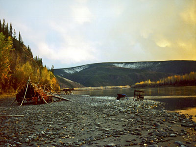
General view
© Parks Canada | Parcs Canada.
Address :
Dawson, Yukon Territory
Recognition Statute:
Historic Sites and Monuments Act (R.S.C., 1985, c. H-4)
Designation Date:
2002-07-18
Event, Person, Organization:
-
Tr’ondëk Hwëch’in First Nation
(Builder)
Other Name(s):
-
Tr'ochëk
(Designation Name)
-
Tr’ondëk Hwëch’in Traditional Territory
(Other Name)
-
Klondike City
(Other Name)
-
Lousetown
(Other Name)
-
Tr’o-ju-wech’in (former name)
(Other Name)
Research Report Number:
2001-026, 2001-OB-12 Nov, 2009-058
Plaque(s)
Existing plaque: Dawson, Yukon Territory
Tr'ochëk, in the middle Chu kon'dëk (Yukon River) valley, lies at the heart of Tr'ondëk Hwëch'in territory. This gathering place is valued for its rich natural resources and its significance to the community in sustaining and transmitting its heritage. Tr'ochëk exemplifies the connection between the land and its people, and speaks to the land as a source of traditional knowledge. The importance of the landscape is expressed in oral histories, language, and place names, and in the continued use of the site. Tr'ochëk is a place where the Tr'ondëk Hwëch'in community reflects upon and shares its culture with others.
Description of Historic Place
Tr’ochëk National Historic Site of Canada lies on an upstream flat at the confluence of the Yukon and Klondike Rivers, just south of Dawson City, Yukon. The Klondike River breaches the high hills along the east bank of the Yukon, just skirting the base of a steep hill that rises to form a high, flat bench. The river flat features a large, open grassy meadow that contains the remains of Hän fish camps, traditional plant harvesting areas and bench lookout points that offer views of traditional Tr’ondëk Hëwch’in First Nation land. Official recognition refers to the alluvial flat on the upriver side of the confluence of the Klondike and Yukon rivers, the hillside backing it to the south and a portion of the Yukon River cliffs just upriver of the confluence.
Heritage Value
Tr’ochëk was designated a national historic site of Canada in 2001 because: it is representative of the Hän cultural landscape of the middle Yukon River valley; the site speaks to the Hän peoples use and understanding of their traditional territories and the land’s role as source and carrier of their traditional knowledge; the value that they place on this landscape is reflected in their oral histories, language, place names and continued use of the site.
Tr’ochëk is representative of the Tr’ondëk Hëwch’in ‘home’ in the middle Yukon River. It contains late prehistoric and protohistoric archaeological resources that attest to the profound influence of the Yukon River on traditional Hän culture, oral histories, language, and place names. For countless generations, the Hän spent the mid-summer to late fall at fishing camps at Tr’ochëk, where they harvested and dried fish, cleaned skins from moose and caribou and prepared other foods for winter storage. The Hän made seasonal use of this site, named Tr’ochëk to signify “the place at the mouth of the river,” until the arrival of thousands of gold seekers during the Klondike Gold Rush of the late 19th century disrupted their traditional patterns.
The Hän people derive practical value from the river, which they use as a transportation route, a source of food, and spiritual value through the associations, stories and symbolic connections that the people have made to it. This cultural landscape also consists of trails and lookout points linked to the oral histories and traditional hunting, fishing and gathering practices of many generations of Hän people.
Source: Historic Sites and Monuments Board of Canada, Minutes, November 2001.
Character-Defining Elements
Key elements contributing to the heritage value of this site include: the location of Tr’ochëk at the confluence of the Klondike and Yukon Rivers; the relationship between the river junction and the open, grassy meadow, the surrounding landscape of hills and mature trees, and the presence of plants traditionally used for subsistence and medicine; the juncture between river and land; the lookout posts along the high bench overlooking the Yukon River, and evidence of mining activity; in-situ evidence of several Hän fish camps, including beads, stone tools, bone and antler implements, fire pits, remains of fish and animal bones and birch bark baskets; the integrity of any surviving or as yet unidentified archaeological remains, which may be found within the site in their original placement; viewscapes from the riverbanks and benches, including the lookouts to the Yukon and Klondike rivers and their valleys.